
Saar (river) facts for kids
Quick facts for kids Saar |
|
|---|---|

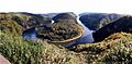
Saar loop at Mettlach
|
|
 |
|
| Countries | France and Germany |
| Physical characteristics | |
| Main source | Sarre Blanche Vosges mountains, Bas-Rhin ±800 m (2,600 ft) 48°31′37″N 7°09′45″E / 48.52694°N 7.16250°E |
| 2nd source | Sarre Rouge Vosges mountains, Moselle ±670 m (2,200 ft) 48°32′05″N 7°10′05″E / 48.53472°N 7.16806°E |
| River mouth | Moselle 49°42′5″N 6°34′11″E / 49.70139°N 6.56972°E |
| Length | 246 km (153 mi) |
| Basin features | |
| Progression | Moselle→ Rhine→ North Sea |
| Basin size | 7,431 km2 (2,869 sq mi) |

The Saar is an important river that flows through parts of France and Germany. It's a "right tributary" of the Moselle river, which means it flows into the Moselle from the right side.
The Saar river starts in the Vosges mountains, which are located on the border between Alsace and Lorraine in France. It then flows north until it joins the Moselle river near the city of Trier in Germany.
The Saar actually begins with two smaller streams: the Sarre Rouge and the Sarre Blanche. These two streams meet near a town called Lorquin in France. Both streams start close to Mont Donon, which is the highest peak in the northern Vosges mountains.
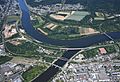
The Saar river is about 246 kilometers (153 miles) long. A part of its journey, about 129 kilometers (80 miles), is in France or along the border between France and Germany. The remaining 117 kilometers (73 miles) are in Germany. Finally, the Saar flows into the Moselle river at a place called Konz, which is in Germany, between Trier and the border with Luxembourg. The area of land that drains into the Saar river is quite large, covering about 7,431 square kilometers (2,869 square miles).

The name "Saar" comes from an old Celtic word, sara, which means "streaming water." The Romans later called the river Saravus.
Contents
Cities and Regions Along the Saar
The Saar river flows through several interesting places in both France and Germany.
In France, it passes through:
- The Moselle region, including towns like Sarrebourg and Sarreguemines.
- The Bas-Rhin region, where you'll find Sarre-Union.
In Germany, the river flows through:
- The Saarland state, with major cities like Saarbrücken and Saarlouis.
- The Rhineland-Palatinate state, where it goes through towns like Saarburg and Konz.
Cool Places and Features

There are some famous spots along the Saar river. One of them is the Völklinger Hütte, which is an old ironworks factory. It's so important that it's been named a UNESCO World Heritage Site. This means it's a special place recognized for its historical or cultural value to the world.
Another amazing sight is the Saar loop near Mettlach. Here, the river makes a dramatic, winding turn, creating a beautiful natural landmark.
The lower part of the Saar river in Germany is also known for growing grapes. This area produces mostly Riesling wine. In the past, much more wine was grown along the river, even as far up as Saarbrücken. Recently, some farmers have started growing grapes again in the Saarland area.
Rivers Joining the Saar
Many smaller rivers and streams flow into the Saar river along its journey. These are called "tributaries." They add more water to the Saar as it flows towards the Moselle.
Some of the main tributaries include:
- Sarre Blanche (joins from the left)
- Sarre Rouge (joins from the right)
- Albe (joins from the left)
- Blies (joins from the right)
- Prims (joins from the right)
- Nied (joins from the left)
River Travel and Transport
The Saar river is important for transporting goods. In 2001, a long section of the river, about 87.2 kilometers (54.2 miles) from Konz up to Saarbrücken, was made better for larger ships. This means that goods can now be transported north, for example, to the big sea port of Rotterdam in the Netherlands.
Historically, the middle part of the Saar was made navigable in 1866. It was used to transport coal upstream (against the current) and iron ore downstream (with the current). A smaller section between Saarbrücken and Sarreguemines can be used by smaller ships.
Also, since 1866, the Canal de la Sarre connects the Saar river to the Marne–Rhine Canal. This canal is about 64 kilometers (40 miles) long and allows smaller ships to travel between these waterways.
Images for kids
-
Saar loop at Mettlach
-
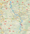
Map of the Saar river
-
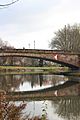
Bridge over the Saar at Saarbrücken
-
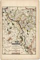
Course of the Saar (1703)
-
Confluence of Saar and Moselle in Konz
See also
 In Spanish: Río Sarre para niños
