
Saarbrücken facts for kids
Quick facts for kids
Saarbrücken
Sabrigge (Rhenish Franconian) Sarrebruck (French)
|
|||
|---|---|---|---|
|
Rathaus St. Johann (city hall)
Berliner Promenade
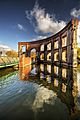
Saarbrücken Castle
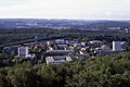
Universität des Saarlandes
Louis' Church
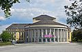
Saarland State Theatre
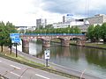
A 620 along the Saar
Saarbahn
|
|||
|
|||
|
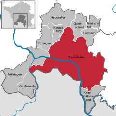
Location of Saarbrücken within Saarbrücken district
 |
|||

Saarbrücken
Location in Germany

Saarbrücken
Location in Saarland
|
|||
| Country | Germany | ||
| State | Saarland | ||
| District | Saarbrücken | ||
| Subdivisions | 20 | ||
| Area | |||
| • City | 167.07 km2 (64.51 sq mi) | ||
| Elevation | 230.1 m (754.9 ft) | ||
| Population
(2022-12-31)
|
|||
| • City | 181,959 | ||
| • Density | 1,089.12/km2 (2,820.80/sq mi) | ||
| • Urban | 329,593 | ||
| • Metro | 700,000 | ||
| Time zone | UTC+01:00 (CET) | ||
| • Summer (DST) | UTC+02:00 (CEST) | ||
| Postal codes |
66001–66133
|
||
| Dialling codes | 0681, 06893, 06897, 06898, 06805 | ||
| Vehicle registration | SB | ||


.jpg)


.jpg)


.png)
Saarbrücken is the capital and largest city in the German state of Saarland. It has about 182,000 people living there. Saarbrücken is the main center for government, business, and culture in Saarland. It is located on the Saar River and is very close to the French border. It is also one of Germany's westernmost state capitals.
The city we know today as Saarbrücken was formed in 1909. Three smaller cities – Saarbrücken (now called Alt-Saarbrücken), St. Johann a. d. Saar, and Malstatt-Burbach – joined together. The area was important for its coal mines and industries like iron and steel.
Some famous old places in the city include a stone bridge over the Saar River from 1546, the old Saarbrücken Castle, and the Sankt Johanner Markt (Market of St. Johann). Saarbrücken has an international airport and is home to the main campus of the University of the Saarland.
In the 20th century, Saarbrücken was separated from Germany twice. First, from 1920 to 1935, it was the capital of the Saar Basin Territory. Then, from 1947 to 1956, it was the capital of the Saar Protectorate.
Contents
- What's in a Name? The Meaning of Saarbrücken
- Saarbrücken Through Time: A Brief History
- Geography and Climate
- People of Saarbrücken: Demographics
- Getting Around and Learning: Infrastructure and Education
- Sports in Saarbrücken
- Global Connections: International Relations
- Famous People from Saarbrücken
- Images for kids
- See also
What's in a Name? The Meaning of Saarbrücken
The name Saarbrücken in German means "Saar bridges." There are many bridges over the Saar River in the city. However, the name is much older than the oldest bridge in the city center.
The name Saar comes from an old Celtic word, sara, which means "streaming water." The Romans later called the river Saravus.
There are two main ideas about where the "brücken" part of the name comes from:
- One idea is that it comes from the Celtic word briga, meaning "hill" or "rock." The old castle of Saarbrücken was built on a large rock overlooking the river.
- Another idea is that it comes from an Old High German word, Brucca, which means "bridge" or a special kind of road used to cross rivers. Near the castle, there was a place where people could cross the Saar River.
Saarbrücken Through Time: A Brief History
Ancient Times: Roman Empire Days
Long ago, before the time of Jesus, a group of people called the Mediomatrici lived in the Saarbrücken area. When the Romans took over Gaul (ancient France) around 100 BC, this area became part of the Roman Empire.
From the 1st to the 5th century AD, there was a Roman settlement called vicus Saravus. It was located near a hill called Halberg. A wooden bridge, later made of stone, connected this settlement to the other side of the Saar River. People also built a special shrine to a god named Mithras in a cave on Halberg hill.
Around the end of the 4th century, a group called the Alemanni destroyed the Roman settlement. For almost 100 years, no one lived permanently in the Saarbrücken area.
Middle Ages to the 1700s
Around the year 500, the Franks took control of the Saar area. In 999, Emperor Otto III gave the Saarbrücken castle to the Bishops of Metz. These bishops then let the Counts of Saargau rule the area. By 1120, the County of Saarbrücken was formed, and a small town grew around the castle.
In 1321 or 1322, Count Johann I gave city rights to Saarbrücken and a nearby fishing village called St. Johann. This meant people living there had more freedom.
From 1381 to 1793, the Counts of Nassau-Saarbrücken ruled the area. In 1549, Emperor Charles V ordered the building of the Alte Brücke (Old Bridge) to connect Saarbrücken and St. Johann. In the early 1600s, Count Ludwig II built a new castle and started the oldest high school in Saarbrücken, the Ludwigsgymnasium.
The Thirty Years' War (1618-1648) greatly reduced the population of Saarbrücken. In 1677, during another war, French troops burned down Saarbrücken, leaving only 8 houses standing. The area became part of France for a short time in the 1680s.
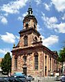
From 1741 to 1768, Prince William Henry ruled. He helped the economy grow by taking control of the coal mines. He also spent a lot of money building new structures. A famous architect named Friedrich Joachim Stengel designed many important buildings that are still in Saarbrücken today. These include the Friedenskirche (Peace Church), the Old City Hall, the St. John's Basilica, and the famous Ludwigskirche, which is a landmark of Saarbrücken.
The 1800s
In 1793, French revolutionary troops took Saarbrücken. After 1815, Saarbrücken became part of Prussia. The region's coal and iron resources were developed. Railways were built, and the Saar River was made easier for boats to use.
At the start of the Franco-Prussian War in 1870, French forces briefly occupied Saarbrücken. There's a story that 14-year-old French Prince Napoléon Eugène Louis Bonaparte fired his first cannon shot here. This event is remembered by the Lulustein memorial.
The 1900s
In 1909, the cities of Saarbrücken, St. Johann, and Malstatt-Burbach officially joined together. This made Saarbrücken a large city with over 100,000 people.
During World War I, factories and railways in Saarbrücken were bombed by British planes.
After World War I, from 1920 to 1935, Saarbrücken became the capital of the Saar territory. This area was controlled by the League of Nations. In 1935, people in the Saar voted to rejoin Germany. More than 90% voted for this.
World War II
Saarbrücken was heavily bombed during World War II. Many homes were destroyed, and a large part of the city was left in ruins. Over 1,200 people died in the bombings. Both British and American planes attacked the city, often targeting industrial areas and railway lines.
On the ground, American troops fought to take Saarbrücken in 1945. After fierce battles, especially around the nearby Spicheren Heights, American forces entered Saarbrücken on March 20, 1945, and fully occupied it the next day.
After World War II
After World War II, Saarbrücken was part of the French Zone of Occupation. In 1947, France created the Saar Protectorate, making it economically linked to France to use its coal. Saarbrücken became its capital.
In 1955, people in the Saar voted again. This time, over two-thirds voted against an independent Saar state. So, on January 1, 1957, the area rejoined West Germany. Saarbrücken became the capital of the new German state of Saarland.
From 1990 to 1993, students and an art professor created an "invisible memorial" to Jewish cemeteries near Saarbrücken Castle.
Geography and Climate
Weather in Saarbrücken
Saarbrücken has a mild climate. This means there aren't huge differences between the highest and lowest temperatures. It also gets enough rain throughout the year. This type of climate is called a "Marine West Coast Climate."
| Climate data for Saarbrücken (1991–2020 normals, extremes since 1935) | |||||||||||||
|---|---|---|---|---|---|---|---|---|---|---|---|---|---|
| Month | Jan | Feb | Mar | Apr | May | Jun | Jul | Aug | Sep | Oct | Nov | Dec | Year |
| Record high °C (°F) | 14.5 (58.1) |
20.5 (68.9) |
24.0 (75.2) |
27.7 (81.9) |
31.2 (88.2) |
35.2 (95.4) |
37.7 (99.9) |
37.1 (98.8) |
32.2 (90.0) |
26.5 (79.7) |
21.2 (70.2) |
17.1 (62.8) |
37.7 (99.9) |
| Mean daily maximum °C (°F) | 4.0 (39.2) |
5.7 (42.3) |
10.3 (50.5) |
14.9 (58.8) |
18.7 (65.7) |
22.1 (71.8) |
24.2 (75.6) |
24.0 (75.2) |
19.5 (67.1) |
14.1 (57.4) |
8.2 (46.8) |
4.7 (40.5) |
14.2 (57.6) |
| Daily mean °C (°F) | 1.5 (34.7) |
2.3 (36.1) |
5.8 (42.4) |
9.7 (49.5) |
13.5 (56.3) |
16.8 (62.2) |
18.7 (65.7) |
18.3 (64.9) |
14.2 (57.6) |
10.0 (50.0) |
5.4 (41.7) |
2.4 (36.3) |
9.9 (49.8) |
| Mean daily minimum °C (°F) | −1.0 (30.2) |
−0.8 (30.6) |
1.8 (35.2) |
4.7 (40.5) |
8.3 (46.9) |
11.5 (52.7) |
13.4 (56.1) |
13.2 (55.8) |
9.6 (49.3) |
6.4 (43.5) |
2.7 (36.9) |
0.0 (32.0) |
5.8 (42.4) |
| Record low °C (°F) | −17.2 (1.0) |
−20.8 (−5.4) |
−14.9 (5.2) |
−6.0 (21.2) |
−2.3 (27.9) |
0.0 (32.0) |
3.7 (38.7) |
3.9 (39.0) |
−0.5 (31.1) |
−6.1 (21.0) |
−11.7 (10.9) |
−18.7 (−1.7) |
−20.8 (−5.4) |
| Average precipitation mm (inches) | 76.2 (3.00) |
65.2 (2.57) |
65.1 (2.56) |
50.0 (1.97) |
73.3 (2.89) |
63.5 (2.50) |
75.3 (2.96) |
71.1 (2.80) |
66.5 (2.62) |
74.1 (2.92) |
80.7 (3.18) |
99.9 (3.93) |
861.0 (33.90) |
| Average precipitation days (≥ 1.0 mm) | 17.3 | 15.7 | 14.6 | 12.6 | 14.2 | 13.1 | 13.9 | 13.5 | 12.6 | 15.6 | 17.8 | 19.1 | 179.9 |
| Average snowy days (≥ 1.0 cm) | 6.8 | 5.0 | 1.7 | 0.1 | 0 | 0 | 0 | 0 | 0 | 0 | 1.6 | 5.0 | 20.2 |
| Average relative humidity (%) | 87.5 | 82.2 | 74.9 | 68.6 | 71.4 | 71.1 | 69.9 | 71.9 | 78.3 | 84.9 | 89.1 | 89.5 | 78.3 |
| Mean monthly sunshine hours | 53.5 | 80.9 | 137.0 | 190.5 | 214.3 | 230.8 | 244.2 | 225.9 | 171.0 | 106.0 | 52.8 | 42.1 | 1,748.9 |
| Source 1: World Meteorological Organization | |||||||||||||
| Source 2: Infoclimat | |||||||||||||
Nearby Cities and Attractions
Saarbrücken is close to several other cities. These include Trier, Luxembourg, Nancy, Metz, Kaiserslautern, Karlsruhe, and Mannheim.
The city's public transport connects to Sarreguemines in France. It also connects to Völklingen, where the old steel works, called the Völklinger Hütte, is a World Heritage Site.
People of Saarbrücken: Demographics
Saarbrücken has a population of about 180,000 people. When it rejoined West Germany in 1957, it had about 125,000 people.
In the 1960s, many guest workers from Italy came to Saarbrücken. Because of this, Italians are the largest group of foreign residents. French people are the second largest group, partly because Saarbrücken is near the French border.
Saarbrücken had its highest population in 1975, with about 205,000 people. Today, with about 180,000 people, it is the second smallest state capital in Germany.
| Largest groups of foreign residents | |
| Country of birth | Population (2022) |
|---|---|
| 4,051 | |
| 2,492 | |
| 2,345 | |
| 2,138 | |
| 1,755 | |
| 1,524 | |
| 1,346 | |
| 1,230 | |
| 1,176 | |
| 1,083 | |
| 1,000 | |
Getting Around and Learning: Infrastructure and Education
Transport Links
Saarbrücken is served by Saarbrücken Airport (SCN). High-speed trains connect Saarbrücken to Paris. The city's tram system, called the Saarbahn, even crosses the border into the French city of Sarreguemines.
Science and Education Centers
Saarbrücken is a hub for learning and research. It is home to the main campus of Saarland University. Many important research centers are located here or nearby.
Some of these research centers include:
- The Max Planck Institute for Informatics, which studies computer science.
- The Max Planck Institute for Software Systems, focusing on software.
- The Helmholtz Institute for Pharmaceutical Research Saarland (HIPS).
- The Fraunhofer Institute for Non-destructive Testing.
- The German Research Centre for Artificial Intelligence.
- The Europa-Institut, which focuses on European studies.
- The Korea Institute of Science and Technology Europe.
- The Leibniz Institute for New Materials (INM).
- The CISPA Helmholtz Centre for Information Security.
Saarland University also has a special center for French and German law. This center offers degree programs in both legal systems.
The Franco-German University is also based in Saarbrücken. It works with many universities in France and Germany to offer special degree programs.
Saarbrücken has several other colleges and universities:
- The University of Applied Sciences Hochschule für Technik und Wirtschaft des Saarlandes.
- The University of Arts Hochschule der Bildenden Künste Saar.
- The University of Music Hochschule für Musik Saar.
The city also has many schools, including the oldest high school in Saarland, the Ludwigsgymnasium, founded in 1604. There is also a special French-German high school, the Deutsch-Französisches Gymnasium. This school works with a French primary school to offer full French-German education from kindergarten through high school.
Sports in Saarbrücken
.JPG)
Saarbrücken is home to several sports teams. The most famous is the football (soccer) team, 1. FC Saarbrücken. They play at the Ludwigsparkstadion. This team used to play in Germany's top league, the Bundesliga, and has a lot of fans from the whole Saarland region.
Another football team in the city is SV Saar 05 Saarbrücken.
The Saarland Hurricanes are one of the best American football teams in Germany. Their junior team won the German Junior Bowl in 2013.
The Saarlandhalle hosts various sports events, including international badminton tournaments.
Global Connections: International Relations

Saarbrücken is part of the QuattroPole union of cities. This group includes Luxembourg, Metz, and Trier. These cities are from Germany, Luxembourg, and France, working together.
Sister Cities
Saarbrücken has special partnerships with other cities around the world. These are called "twin towns" or "sister cities":
 Nantes, France (since 1965)
 Tbilisi, Georgia (since 1975)
 Cottbus, Germany (since 1987)
 Kovel, Ukraine (since 2023)
Some smaller parts of Saarbrücken also have sister city relationships:
- Altenkessel is twinned with Coucy-le-Château-Auffrique, France.
- Dudweiler is twinned with Saint-Avold, France.
- Klarenthal is twinned with Schœneck, France.
Friendly Cities
Saarbrücken also has friendly relationships with:
 Diriamba, Nicaragua
And Dudweiler has a friendly relationship with Duttweiler, a part of Neustadt an der Weinstraße, Germany.
Famous People from Saarbrücken
Arts and Entertainment
.jpg)
- Frédéric Back (1924–2013), a Canadian artist and director of animated films.
- Ingrid Caven (born 1938), an actress.
- Sandra Cretu (born 1962), a singer.
- Nicole (born 1964), a singer.
- Max Ophüls (1902–1957), a film director.
- Wolfgang Staudte (1906–1984), a film director.
- Otto Steinert (1915–1978), a photographer.
Public Service
.jpg)
- Peter Altmeier (1899–1977), a politician.
- Rudolf Arthur Pfeiffer (1931–2012), a German geneticist who discovered Pfeiffer syndrome.
- Gerhard Schröder (1910–1989), a politician.
- Frederic Vester (1925–2003), a biochemist.
Sports
.JPG)
- Jonas Hector (born 1990), a footballer.
- Claudia Kohde-Kilsch (born 1963), a tennis player and politician.
- Lisa Klein (born 1996), a cyclist.
Honorary Citizens
- Tzvi Avni (born 1927), an Israeli composer.
- Willi Graf (1918–1943), a member of the White Rose resistance group.
Images for kids
-
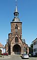
Stiftskirche St. Arnual
-
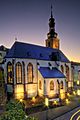
Schlosskirche St. Nikolaus
-
Friedenskirche, seen from Ludwigsplatz
-
St. John's Basilica
-
Alte Brücke (Old Bridge)
-
Staatstheater (State Theatre)
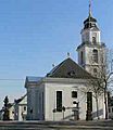
-
St. Michael
-
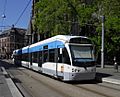
Saarbahn tramway
-
Central station
-
Saarbrücken Airport
-
Harbour Road
-
Bürgerpark
-
Campus of Saarland University
-
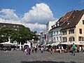
St. Johanner Markt

.jpg)


See also
 In Spanish: Saarbrücken para niños
