
Sauer facts for kids
Quick facts for kids Sauer/Sûre |
|
| River | |
 The Sauer at Weilerbach, forming the border between Luxembourg and Germany.
|
|
| Countries | |
|---|---|
| Region | Ardennes |
| Tributaries | |
| - left | Wiltz, Our, Prüm |
| - right | Alzette, White Ernz, Black Ernz |
| Cities | Ettelbruck, Diekirch, Echternach |
| Source | |
| - location | Vaux-sur-Sûre, Belgium |
| - elevation | 510 m (1,673 ft) |
| - coordinates | 49°54′39″N 5°33′59″E / 49.91083°N 5.56639°E |
| Mouth | |
| - location | Moselle, Luxembourg & Germany |
| - elevation | 132 m (433 ft) |
| - coordinates | 49°42′48″N 6°30′24″E / 49.71333°N 6.50667°E |
| Length | 173 km (107 mi) |
| Basin | 4,240 km² (1,637 sq mi) |
| Discharge | for Bollendorf |
| - average | 40.5 m³/s (1,430 cu ft/s) |
The Sauer (called Sûre in French) is a river that flows through three countries. These countries are Belgium, Luxembourg, and Germany. It is like a smaller river that joins a bigger one, the Moselle. The Moselle then flows into the Rhine River, so the Sauer is part of the huge Rhine river system.
Contents
About the Sauer River
The Sauer river is about 173 kilometers (107 miles) long. It collects water from a large area of land, called its drainage basin. This area covers about 4,240 square kilometers (1,637 square miles).
Where the River Starts

The Sauer river begins in the southeast of Belgium. This area is known as the Ardennes forest. It starts high up, about 510 meters (1,673 feet) above sea level. This starting point is in the Luxembourg province of Belgium.
The River's Journey
From where it starts, the Sauer river flows towards the east. It crosses the border into Luxembourg near a town called Martelange. For about 13 kilometers (8 miles) north of Martelange, the river forms the border between Belgium and Luxembourg.
As it travels through the northern part of Luxembourg, which is quite hilly, it flows into a large artificial lake. This lake is called Lac de la Haute Sûre. You can find this lake west of Esch-sur-Sûre.
After passing through towns like Ettelbruck and Diekirch, the Sauer river forms another border. For its last 50 kilometers (31 miles), it marks the border between Luxembourg and Germany. It flows past Echternach before finally joining the Moselle river. This meeting point is in Wasserbillig, Luxembourg, at about 132 meters (433 feet) above sea level.
Rivers Joining the Sauer
Many smaller rivers flow into the Sauer river. These are called tributaries. They add water to the Sauer as it flows.
Left Side Tributaries
- Wiltz - about 42 kilometers (26 miles) long
- Blees - about 14 kilometers (9 miles) long
- Our - about 78 kilometers (48 miles) long
- Gaybach - about 23.2 kilometers (14.4 miles) long
- Prüm - about 95 kilometers (59 miles) long
Right Side Tributaries
- Alzette - about 73 kilometers (45 miles) long
- White Ernz - about 30 kilometers (19 miles) long
- Black Ernz - about 25 kilometers (16 miles) long
Gallery
-
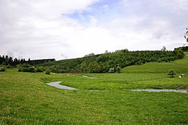
Upper Sauer at Winville
-
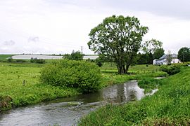
Upper Sauer at Sûre
-
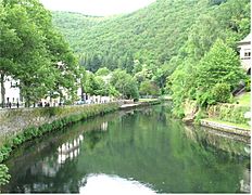
The Sauer at Esch-sur-Sûre
-
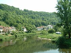
The Sauer at Wallendorf


Related pages
See also
 In Spanish: Sûre para niños
