
Sierra Madre Occidental facts for kids
Quick facts for kids Sierra Madre Occidental |
|
|---|---|

|
|
| Highest point | |
| Peak | Cerro Mohinora |
| Elevation | 10,863 ft (3,311 m) |
| Dimensions | |
| Length | 932 mi (1,500 km) NW x SE |
| Width | 150 mi (240 km) W x E |
| Geography | |
 |
|
| Country | Mexico |
| State | Sonora, Chihuahua, Sinaloa, Durango, Zacatecas, Nayarit, Jalisco, Aguascalientes |
| Region | Northwestern Mexico |
| Borders on | |
The Sierra Madre Occidental is a huge mountain range in western Mexico. It stretches from the northwest to the southeast, running along the Gulf of California. This mountain system is part of the larger American cordillera, which is a long chain of mountains forming the western "backbone" of North and South America.
The name Sierra Madre means "mother mountain range" in Spanish. Occidental means "western." So, it's the "Western Mother Mountain Range." There's also a "Eastern Mother Mountains" range, called the Sierra Madre Oriental, which runs parallel to this one.
This mountain range starts near the Mexico-U.S. border in Sonora state. It goes southeast until it meets the Trans-Mexican Volcanic Belt and Sierra Madre del Sur ranges. The mountains form a high, flat area called a plateau. This plateau is cut by deep river valleys. The rocks here are mostly volcanic, sitting on older metamorphic rocks.
The mountains cause more rain to fall, creating special wet areas. These areas are like "islands" of different plants and animals in a mostly dry landscape. The water from the mountains also feeds rivers. These rivers provide water for farming in the drier lands around the mountains. Oak forests are very common here, even reaching into the deserts nearby.
For a long time, many native groups lived in these forests and canyons. Later, Spanish settlers came, often with mestizo people. They built towns, especially for silver mines. Today, farming and forestry are big industries. But these activities sometimes cause land degradation and conflict with native communities.
Contents
Where is the Sierra Madre Occidental?


This mountain range runs from north to southeast. Many rivers have carved deep Canyons into the mountains. The most famous is the Copper Canyon, which is even bigger and deeper than the Grand Canyon in some places.
The Sierra Madre Occidental runs next to Mexico's Pacific coast. It starts just south of the Arizona-Sonora border. Then it goes through eastern Sonora, western Chihuahua, Sinaloa, Durango, Zacatecas, Nayarit, Jalisco, and Aguascalientes. It finally connects with the Sierra Madre del Sur and the Transverse Volcanic Axis in Guanajuato. This whole stretch is about 1,250 kilometers (777 miles) long.
In the north, the mountains are about 300 kilometers (186 miles) from the Gulf of California. But in the south, they get as close as 50 kilometers (31 miles) to the Pacific. These mountains are part of the larger American cordillera, which includes mountains from Alaska all the way down.
What are the different parts of the range?
The northern part of the Sierra Madre is often called Sierra Tarahumara. This name comes from the Tarahumara native people who live there. It's a dramatic area with steep mountains and deep canyons, like the famous Copper Canyon. This high plateau is about 2,250 meters (7,380 feet) high on average. The western side has more eroded canyons because it gets more rain.
The highest points in the Sierra Madre are in the Tarahumara region. The exact height of the tallest peaks is hard to know precisely. Cerro Mohinora is likely the highest point. Its height is estimated to be between 3,040 meters (9,970 feet) and 3,300 meters (10,800 feet).
The southern end of the mountains is sometimes called the Sierra Huichola. Here, the Sierra Madre starts to change into a different type of landscape with basins and smaller mountain ranges.
How do rivers flow in the mountains?

The mountains are a very important source of water for the surrounding dry areas. They get more rain, and this water flows into rivers. These rivers then provide water for irrigation to grow crops in the drier lands. Building dams to store this water has caused some environmental concerns.
The northern part of the range is drier. The Yaqui River is a key water source for farming in Sonora state. The Yaqui River flows into the Gulf of California, as do the Humaya River and the Fuerte River further south. The Río Grande de Santiago drains a huge area of 100,000 square kilometers (38,610 square miles) from the southern mountains.
On the drier eastern side, the Nazas River and Aguanaval River flow into a closed basin, meaning their water doesn't reach the ocean. These mountains provide 90% of the water used for irrigation in that area. North of this, the Conchos River flows into the Rio Grande.
Many rivers have been dammed to provide water for farming. For example, the Yaqui River has three large reservoirs. The Río Grande de Santiago also has dams, like the Aguamilpa Dam. The Nazas River was dammed in the 1930s and 1940s. This caused lakes in the area to dry up and led to soil problems because the river no longer brought fresh soil. Also, continued logging in the mountains has increased erosion on the hillsides.
How do people live in the mountains?
Many small communities live in Copper Canyon, some near old missions. Many settlements are just single families or small groups living near their farms. There are also a few towns, like Creel, Chihuahua, which has about 5,000 people and is a stop on the train line. South of Copper Canyon is El Salto, Durango, on highway 40. To the west is Copala, Sinaloa.
In the south, the native Cora people live in towns like Jesús María and La Mesa del Nayar. About 1,000 people live in Huajimic in Nayarit. The Bolaños River valley in Jalisco has mining towns, such as San Martín de Bolaños, with about 3,000 people.
Not many paved roads cross the mountains. This means travel can take a long time, even between towns that seem close. In the north, Mexico Federal Highway 16 connects Hermosillo, Sonora, and La Junta, Chihuahua. The La Entrada al Pacifico Corridor is a road still being built to connect Los Mochis, Sinaloa, and Chihuahua. Durango and Mazatlan are linked by highway 40.
What is the geology of the Sierra Madre Occidental?
The Sierra Madre Occidental is a high plateau made of volcanic rock. In some places, this rock has worn away, showing older plutonic and sedimentary rocks underneath. There are two main types of volcanic rocks. The lower layer is made of lava flows. The top surface of the plateau is made of a second type of volcanic rock called ignimbrites. These are mostly covered by clay-rich soils. Some rock formations in the area have valuable ores, like silver.
The landscape was shaped after the rocks were formed. Rivers cut valleys into the plateau, often following folds in the rocks. Rocks have broken off the slopes, creating rocky sides. The solid rock is covered by clay-rich soils, except in areas where water has carried the soil away, leaving a stony surface.
How did the mountains form?
The base of the mountains is thought to be old North American rock. It also includes different pieces of land called accreted terranes that joined together. Most of these are covered by younger volcanic rocks. The northern part of the Sierra Madre includes the Cortés Terrane. Some of the northern end might also have very old rock from the Precambrian era.
Towards the end of the Cretaceous period, a lot of volcanic activity happened. This formed the first major series of volcanic rocks. These rocks include both deep intrusive rocks and surface volcanic rocks. In the middle of the range, some of these rocks were shaped by forces in the Earth's crust. This volcanic activity ended in the Paleocene epoch. Later, in the Eocene epoch, more volcanic rocks formed, including andesitic and rhyolitic types. Most of the gold and silver deposits are found in these rocks.

In the Oligocene epoch, ash flows became very common. These ash flows started a second period of intense volcanic activity. This event, called the Mid-Tertiary ignimbrite flare-up, created many layers of ignimbrite, one on top of another. Sometimes, lava flows broke through these layers. This area has the largest known series of ignimbrite formations, with ten calderas (large volcanic craters) identified. Three of these calderas are in Copper Canyon.
During the Miocene epoch, three different periods of volcanic activity occurred. The first was a continuation of the Oligocene flare-up. The second involved Basaltic andesites forming along faults. The third, starting in the middle Miocene, was linked to the opening of the Gulf of California. These events are also connected to the Farallon Plate moving under the North American plate. Volcanic activity continued into the Quaternary period.
What are the rocks and faults like?
The Sierra Madre is thought to have a thick core of rock covered by volcanics. Many rivers have carved into it. Some believe that the base of the mountains has many intrusions of mafic magma. On the surface, the mountains are made of a large sheet of ignimbrite, cut by rivers. The surface is mostly ignimbrites with layers of lava flows.
Faults (cracks in the Earth's crust) in the area are usually younger than the top volcanic layers. Large faults along the eastern slope have created huge cliffs facing the interior basins. These faults are often covered by alluvium (river deposits) and basalt, making them hard to see.
Grabens (sunken blocks of land) have formed in the north. Long depressions have formed in the southern Sierra Madre. Faulting decreases in the center of the range but increases on the western slope. Some faults might have allowed ignimbrites to erupt from the surface.
Two main faults separate the Sierra Madre from the central Mexican Plateau. The Aguascalientes fault runs north-south. The San Luis–Tepehuanes fault runs northwest-southeast. The southern edge of the Sierra Madre has many folds and faults from the middle Miocene.
What minerals are found here?
The Sierra Madre mountains have many valuable mineral deposits. These deposits formed at different times and in different ways. The Guerrero composite terrane, a large block of land, contains many important economic deposits.
Gold and silver are most often found in the older volcanic rocks, usually between 30 and 50 million years old. These are thought to have been caused by later intrusions into the early lava flows. Gold and silver deposits also occur in fissure veins, divided into eastern and western groups. In the east, gold and silver are found with lead and zinc. In the south, the Bolaños mine district is in the Bolaños Graben.
Besides gold and silver, tin, iron, and mercury are also found. Molybdenum is found with older copper deposits. The main belt of tin deposits is on the eastern slopes from Durango to Guanajuato. Here, tin is found in rhyolitic ignimbrites in many small deposits of cassiterite. Many of these are thought to be hydrothermal deposits (formed by hot water). East of these are mercury deposits, then manganese deposits.
Iron is found in three different areas. Along the Pacific, there are deposits with gold. In Durango, iron is found as magnetite lava flows. There is also another belt of iron deposits further east.
What are the soils like?
Most soil in the mountains has a rich organic layer over layers rich in clay. These soils are often phaeozems, up to 100 centimeters (39 inches) deep. Some soils are cambisols, less than 2 meters (6.6 feet) deep and well-drained. Because of the high clay content, which can stop water from soaking in, larger rock particles in the soil help reduce runoff and erosion. Areas covered in stone are called lithosols, especially on upper slopes. Another soil type is vertisols, which are thin and poor in minerals.
Soils at higher elevations get more leaching (nutrients washed away) due to increased rainfall. Acidic soils may have less calcium, which can make them less fertile for plants. Soils on the eastern slopes have more organic content and a thicker clay layer than those in drier eastern lands. The soil layers also get thicker.
Problems with soil damage have become worse due to the growing of illegal crops, leading to deforestation. Other problems include overgrazing by cattle, which creates paths and a soil crust, and soil acidification, which can harm grasslands.
What is the climate like?
The climate changes a lot from the northern to the southern parts of this long mountain range. Seasonal changes also happen because of the large warm bodies of water on both sides of the range. This region has two wet seasons, including a summer monsoon, and two dry seasons each year.
Temperature, pressure, and wind patterns
Changes in air pressure in northwestern Mexico and the southwest United States cause the main seasonal changes in the Sierra Madre. A high pressure area sits over the mountains in winter. In June, it moves north into New Mexico. This high pressure starts to break down and move south in September or October, but more slowly.
The climate in the mountains is mild. Summer temperatures stay fairly constant. The highest temperatures are usually in July, around 31°C (88°F). Average temperatures during this time are about 16°C (61°F). The average yearly temperature is between 13°C and 18°C (55°F and 65°F) above 1,800 meters (6,000 feet). Freezing temperatures can happen in the higher mountains, with snowfall at certain times of the year.
During the summer monsoon, wind patterns change a lot. In May, there's little large-scale wind through the mountains. As the high pressure moves north, air is pulled from the Gulf of Mexico, bringing easterly winds to the mountains. On the east slope, daytime winds blow uphill. The mountains cause air to rise, leading to storms during the monsoon season. At night, low-level winds bring moisture. After the high pressure breaks down, wind patterns return to how they were before the monsoon.
Rainfall and humidity
Rainfall varies a lot each year and season in the Sierra Madre. Annual differences are linked to El Niño, with El Niño years bringing more rain. Monsoon rains arrive in June as the high pressure moves north, causing wet summers. This brings east winds with moisture from the Gulf of Mexico. On the western side, which sees the biggest change between dry and monsoon seasons, rainfall can be over 300 millimeters (12 inches) in a single month during the monsoon. The southern region gets more rain than the northern. Much of this rain comes from tropical storms. Because of the monsoon, most of the year's rain falls in summer. A weaker wet season happens in winter, separated by dry seasons in spring and fall. Rainfall also increases at higher elevations.
Humidity in the mountains also varies widely, just like rainfall. In the early morning, before dawn, the air near the mountain tops is almost saturated with moisture (often over 90% relative humidity), with low clouds. Lower down, the air is not as moist in the morning. Seasonal changes in humidity are also present. Average relative humidity in May and June is around 50%, but can drop to 25% during the day. As temperatures rise during the day, relative humidity drops, and cloud levels rise. The humidity is also affected by the same seasonal changes as rainfall, increasing with the monsoon.
What is the ecology of the Sierra Madre Occidental?

The mountains create a very diverse environment for plants and animals. They offer different conditions than the surrounding areas. The Sierra Madre Occidental pine-oak forests are found at elevations between 1,500 and 3,000 meters (4,900 and 9,800 feet) throughout the range. These forests change depending on the elevation and location. This area is known for its high biodiversity (many different types of life) and a large number of endemic species (found only here). It also allows some species to live in areas they normally wouldn't.
Plants and trees: Flora
The main types of plants change across the range. The habitat they create can be scattered woodland, or deciduous (lose leaves) and coniferous (cone-bearing) forests.
Elevation and latitude are the main things that decide which plants grow where. Oaks are common in the lower parts of the mountains, growing down to about 1,000 meters (3,300 feet). Some oak species even grow in the surrounding deserts. On the western slopes, cloud forests can be found, mostly on mid-elevation slopes that are protected from wind and sun in the southern part of the range. At higher elevations, pines start to grow with the oaks, and then pines become more common than oaks. At very high elevations and in the north, mixed conifer forests become the main ecosystem. These forests are mostly made of pines and firs. There are also grasslands on some mountain tops, surrounded by forest.
Plants in the area usually react strongly to seasonal climate changes. The monsoon season has the biggest effect, with new leaves appearing just a few months after the rains begin. The peak flowering season happens in the months before the summer monsoon. However, plants flower throughout the year. Because they flower early, fruit is ripe and seeds are spread at the start of the rains. In some areas, plants don't react much to the seasons, especially where it's always moist due to elevation. These plants might keep their leaves even during the dry season, when most deciduous trees lose theirs.
Animals: Fauna
The mountains often act as a corridor for species. This means animals can travel through, increasing the diversity in the area. Animals usually found in dry and mountainous places share the mountains with species from further south.
Many carnivorous (meat-eating) and omnivorous (meat and plant-eating) mammals live here. However, some are now gone from the area or are endangered. The Mexican wolf's range is now limited to the foothills of Durango, or it might be gone completely. The black bear population is small, and the Mexican grizzly bear is now extinct. Jaguars and ocelots are also rare. But mountain lions and bobcats are more common. On the eastern slopes, you can find American badgers, coyotes, and gray foxes. Native hoofed animals include the white-tailed deer, mule deer, and collared peccary. Rodents and rabbit-like animals include the eastern cottontail, cliff chipmunk, rock squirrel, Mexican fox squirrel, and various types of Cricetidae (a family of rodents). Raccoons, hog-nosed skunks, and hooded skunks also live in the mountains. The white-nosed coati lives on the western slopes, and the ring-tailed cat lives throughout the range. Many species of bats also live in the mountains.
A variety of lizards live in the area. The Tarahumara frog prefers moving water in oak and pine forests. The Sonoran mountain kingsnake's range extends from the Chihuahuan desert into the mountains. Many other snakes and frogs live here, especially on the western slopes.
Birds are common in the mountains. Some use the area as a migratory path, while others are native species. Migratory birds often spend winter in the west and fly north along the western slopes. In the northern canyons, birds might live in different habitats based on the type of forest, leading to different ranges by altitude. This altitude difference can even extend the range of some species, allowing tropical species to use mountain valleys for migration. Birds found only in the Sierra Madre Occidental include the tufted jay, a subspecies of red warbler, eared quetzal, and thick-billed parrot. The imperial woodpecker used to live here but is now likely extinct.
The rivers and streams in the mountains have some of the southernmost trout populations in North America. It's debated whether these populations are native. Invasive fish compete with native species, which is a concern for researchers, along with the effects of logging.
What are the surrounding areas like?
The Sonoran Desert is found in the northwestern foothills, at elevations between 1,000 and 2,000 meters (3,300 and 6,600 feet). The Chihuahuan Desert is to the northeast and east. The Meseta Central matorral and Central Mexican matorral are to the southeast. The Sinaloan dry forests are to the west and southwest. These lower elevations often blend into tropical deciduous forests. These forests have many flowering plants and legumes, especially from the Bursera genus. This transition area, or ecotone, is often sparsely populated, sometimes with only small groups of trees. It can be called a savanna.
How are the mountains protected?
Modern conservation efforts include those by Edwin Bustillos. Other groups, like Conservation International, work to protect animal species. Basaseachic Falls National Park is a national park in the mountains. It has the highest waterfalls in Mexico. Since 1979, there has also been the Cumbres de Majalca National Park where the Chihuahuan Desert meets the Sierra. There are also reserves like La Michilia in the southern Sierra Madre, and the Tutuaca reserve in western Chihuahua, which was created in 2000.
Who lives in the Sierra Madre Occidental?

The mountains are home to several native groups who speak Uto-Aztecan languages. These include the Tarahumara in the central part of the range, the Huichol in the south, and the Tepehuanes on the eastern slopes.
Early history of the mountains
We know that ancient cultures lived in the Sierra Madre and the surrounding lands. However, not much is known about their specific ways of life. The Chalchihuites Culture started as farming communities around 1 AD. They grew until about 500 AD when new farming methods led to a big population increase. This culture began to decline in the 9th century. The Mogollon culture lived in the northern foothills. Their sites date from around 900 AD to 1000–1100 AD. Around the time the Mogollon culture ended, the Rio Sonora culture began farming along the Rio Sonora and its rivers. They made pottery and lived in pit houses until 1150-1200 AD, when they started building houses on the surface. This type of house building stopped around 1550 AD.
Spanish arrival in the Sierra Madre
Francisco de Ibarra arrived in Durango in 1554 and began to settle the area. He explored the western coast and crossed the Sierra Madre in 1564. Early Spanish influence came from new silver mines, with the first one opening in 1567 at Santa Barbara. As mines opened, missionaries came, and by 1595, they had a strong presence. The first meeting with the Tarahumara people happened in 1607.
Opposition to the missionaries grew, leading to the Tepehuán Revolt. This revolt started in 1616 in Santa Catarina de Tepehuanes in Durango and lasted two years. The discovery of silver at Parral in 1631 pushed Spanish settlement further into Tarahumara lands.
The Jesuits (a group of missionaries) restarted their work in the 1630s. Their efforts grew until about 1650. The Tarahumara moved deeper into the mountains to escape the difficult conditions. A smallpox epidemic caused a revolt in 1645. Another revolt happened in 1648, mainly among the Tarahumara. A drought led to two more revolts in 1650 and 1652. The last major revolt began in March 1690 among the Tarahumara and ended in 1698.
Demands for forced labor increased in the 1720s, putting new pressure on the missions. Criticism of the Jesuits grew in the 1730s, with complaints about their business activities. In 1767, the Jesuits were expelled from New Spain, ending their mission program.
A new colonial official, José de Gálvez, came to New Spain. He created new laws that caused a boom in silver mining in the 1770s. After the Apache faced stronger resistance from the Spanish in Chihuahua, they moved to the Sierra Madre in 1794. By 1800, their raids had mostly stopped.
The Sierra Madre in modern Mexico

After leaving San Carlos in 1881, Geronimo and other Apache moved to the mountains. They became known as the Nednai, or "Pinery Apache." From there, they raided Sonora until General George Crook entered the mountains in 1883 to discuss Geronimo's return. Geronimo finally surrendered in 1886. Pancho Villa fled to the mountains in 1894 and became a bandit.
19th century changes
Railroads arrived in the 1880s and 1890s. This allowed many old mines to reopen and become profitable. Most of these railroads were American, and this foreign influence caused unrest among the mountain people. This led to the Tomochic rebellion in 1892. Besides railroads, canals were built in the 1890s in the Yaqui and Mayo river valleys. However, these canal projects failed because native people in the valleys resisted them. Loggers started coming to the mountains in the late 1800s. In response, the Tarahumara moved deeper into the canyons.
20th century changes
The Mexican Revolution began in Chihuahua in 1910 and spread across the mountains through the winter of 1910–1911. Silver mines had to pay the rebels but were allowed to keep operating. General John J. Pershing began to follow Pancho Villa in 1916 and entered the mountains. However, he received no help from the local people. The raids ended by 1919, and Villa returned peacefully to the foothills.
To build irrigation projects in the lowlands, the Yaqui River was dammed in the 1930s. More dams were built in the 1940s and 1950s on the Yaqui River and its smaller rivers. The largest reservoir, behind the Oviachic dam, was finished in 1952. Dams were also built on the Mayo River. Because of the dams, soil quality got worse, and more work was needed to improve it. The Ferrocarril Chihuahua al Pacifico railroad crossed the mountain range and was completed in 1961. The railroad was put up for sale in 1996, but no sale was ever completed.
Images for kids
-
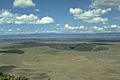
The Durango Volcanic field

See also
 In Spanish: Sierra Madre Occidental para niños
