
Nayarit facts for kids

Nayarit, officially known as the Free and Sovereign State of Nayarit, is one of the 31 states that, along with Mexico City, make up Mexico. It is divided into 20 municipalities, and its capital city is Tepic.
Nayarit is bordered by the states of Sinaloa to the northwest, Durango to the north, Zacatecas to the northeast, and Jalisco to the south. To the west, Nayarit has a long coastline along the Pacific Ocean. This includes the beautiful Marías and Marietas islands. The beaches of San Blas and the famous "Riviera Nayarit" are very popular with tourists. Besides tourism, the state's economy mainly relies on farming and fishing.
This region was once home to Uto-Aztecan native peoples like the Huichol and Cora. In the 16th century, Spanish explorers like Hernán Cortés and Nuño de Guzmán arrived. Spanish rule was difficult because native people often rebelled, and the Sierra del Nayar mountains made the land hard to control. The last independent Cora communities were taken over by force in 1722. The state's name, Nayarit, comes from the Cora people's own name for themselves, Náayerite, honoring a resistance leader named Nayar.
Contents
A Look at Nayarit's Past


Scientists use Radiocarbon dating to guess when people first settled the western Mexican coast, including parts of Sinaloa, Nayarit, and Jalisco. This might have happened as early as 900 AD, or even 520 AD. When the Spanish arrived in the 1500s, the cultures they found on the western coast were descendants of these early settlements.
Hernán Cortés was the first European known to enter the area we now call Nayarit. He claimed it for Spain as part of a larger region called Nueva Galicia. Later, under Nuño de Guzmán, the Spanish took control of the region with great force. This led to native people revolting in what was known as the Mixtón War. After almost 200 years of fighting, the last independent Cora communities were finally brought under Spanish rule in 1722. After this, Jesuit missionaries worked hard to convert the native people to Christianity.
During the time of Spanish rule, the port of San Blas was one of the most important trading ports on the Pacific coast of the Americas. Large ships called Galleons, carrying goods from Manila in the Philippines, would arrive here. This was before the port of Acapulco became more important. Today, the town still has beautiful colonial buildings from its busy past. These include the customs office, accounting offices, and a fortress that protected the port from pirates.
In Nayarit, the fight for independence from Spain began with a priest named José María Mercado. He took control of Tepic and San Blas but was later defeated and executed by Spanish loyalists. In 1824, when Mexico's first constitution was written, Nayarit was part of the state of Jalisco. During the second half of the 1800s, Nayarit was a very troubled area in Mexico. The people were often rebelling, demanding access to land. Nayarit was one of the last areas to become a full state of the Mexican federation. This finally happened on May 1, 1917.
Exploring Nayarit's Geography

Nayarit covers about 27,815 square kilometers (10,739 square miles), making it one of Mexico's smaller states. It is located between specific latitude and longitude lines. The land is broken up by the western parts of the Sierra Madre Occidental mountains. Some of its highest mountains are San Juan, Sanguangüey, El Ceboruco, Cumbre de Pajaritos, and Picachos. Nayarit also has two volcanoes, Ceboruco and Sangangüey.
In the northeast, there are wide, tropical plains. These plains are watered by the Río Grande de Santiago, which is a continuation of the Lerma River. The main rivers in the state are the Río Grande de Santiago, San Pedro, Acaponeta, Ameca, and Las Cañas. The Río Grande de Santiago is the largest river in Nayarit. The Santiago River and its smaller rivers are very important for watering farms. The Ameca and Las Cañas rivers are located on the borders between Nayarit and the states of Jalisco and Sinaloa. Important lagoons in Nayarit include Santa María del Oro, San Pedro Lagunillas, and Agua Brava.
Nayarit's Municipalities

Like all states in Mexico, Nayarit is divided into smaller areas called municipalities (or municipios). There are twenty municipalities in Nayarit:
- Acaponeta
- Ahuacatlán
- Amatlán de Cañas
- Bahía de Banderas
- Compostela
- El Nayar
- Huajicori
- Ixtlán del Río
- Jala
- La Yesca
- Rosamorada
- Ruíz
- San Blas
- San Pedro Lagunillas
- Santa María del Oro
- Santiago Ixcuintla
- Tecuala
- Tepic
- Tuxpan
- Xalisco
Nayarit's Environment and Wildlife
Nayarit has hundreds of miles of rainforest in its mountains. Its wildlife includes many bird species, such as the lilac-crowned amazon and the Mexican woodnymph. There are also 119 different types of mammals. These include white-tailed deer, collared peccary (a type of wild pig), caymans (like small alligators), armadillos, and wild cats. Some of these wild cats are the jaguarundi and the ocelot.
Sadly, much of the rainforest has been cut down, especially around the Santa María del Oro region. Protecting and saving Nayarit's rainforest and its amazing wildlife is extremely important.
The Islas Marías islands were named a Islas Marías Biosphere Reserve by UNESCO in 2010. This means they are a special place protected to help nature thrive.
Amazing Plants and Animals of Nayarit
| Flora and Fauna of Nayarit | |||||||
 |
 |
 |
 |
 |
|||
| Puma yagouaroundi, eyra cat |
Micrurus, coral snake |
Centruroides suffusus, bark scorpion |
Aquila chrysaetos, golden eagle |
Zenaida macroura, mourning dove |
|||
 |
 |
 |
 |
||||
| Amazona finschi, lilac-crowned amazon |
Crotalus basiliscus, green rattler |
Odocoileus hemionus, mule deer |
Canis latrans, coyote |
Falco peregrinus, peregrine |
|||
 |
 |
 |
 |
 |
|||
| Agave tequilana, tequila agave |
Opuntia ficus-indica, cactus pear |
Echinocactus grusonii, golden barrel cactus |
Cylindropuntia imbricata, cane cholla |
Pinus ponderosa, ponderosa pine |
|||
Images for kids
-
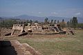
The ancient ruins of Los Toriles
-
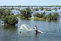
A shrimp fisherman on the coast of Nayarit


See also
 In Spanish: Nayarit para niños
