Ixtlán del Río facts for kids
Quick facts for kids
Ixtlán del Río
|
||
|---|---|---|

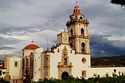
Church in Ixtlán del Río
|
||
|
||

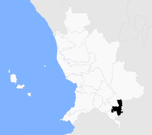
Ixtlán del Rio, Nayarit
|
||
| Country | ||
| State | ||
| Municipality | Ixtlán del Río | |
| Time zone | UTC−7 (MST (Zona Pacífico)) | |
| • Summer (DST) | UTC−6 (MDT (Zona Pacífico)) | |
Ixtlán del Río is a city and a municipality in the Mexican state of Nayarit. In 2018, about 33,289 people lived in the municipality. The city itself had around 35,180 residents. The total area of the municipality is 581.4 square kilometers.
Locals often call it simply Ixtlán. It is located 149 kilometers south of Tepic, the state capital. The city is connected to Tepic and Guadalajara by both train and highway. A major road, Route 15, goes through the city. There is also a toll road that passes to the east.
Ixtlán shares borders with other municipalities. To the north are La Yesca and Jala. To the south, it borders Amatlán de Cañas and the state of Jalisco. Jalisco is also to the east, and Ahuacatlán is to the west.
Most of the land (60%) is mountainous. There are some flat areas near small rivers. These flat areas are used for farming and where towns are built. The weather is hot and a bit humid. Rain usually falls from March to July. The average temperature is between 21°C and 25°C. It can get as cold as 0°C or as hot as 48°C. The area gets about 859.8 mm of rain each year.
The local economy relies on services. This is because the town is on the important Mexico-Nogales highway. There are also small factories that make bricks, furniture, and pottery. Farming is another key part of the economy. Main crops include maize (corn), sorghum, beans, and green chile peppers. In 1995, there were about 36,000 cattle in the area.
South of the city is Toriles. This is the most important ancient site in northwestern Mexico. Here you can find the temple of Quetzalcoatl. This temple was built by the Toltec people. Pottery and gold jewelry found here are displayed in the Regional Museum of Ixtlán.
The Río Grande de Santiago river flows along the eastern edge of the municipality. This is a smaller river and should not be confused with the larger Río Grande de Santiago that flows from Jalisco into Nayarit.
Contents
What's in a Name?
The name Ixtlán comes from the Náhuatl language. It combines "Itz-tli," which means obsidian, and "tlán," meaning "place where it is found." So, Ixtlán means "place where obsidian is found" or "place of the obsidian knife." Obsidian is a dark, glass-like rock formed from volcanoes.
Exploring Ixtlán's Geography
The city of Ixtlán sits on top of the Trans-Mexican Volcanic Belt. This area is shaped by the El Molcajete volcano. There are also hills like Las Panochas, El Borrego, and Mezquites.
The city has two main rivers. The Río Grande de Santiago starts in the Pajaritos Mountains. The Río Chico begins in the mountains of Juanacatán. Many smaller streams flow only during the rainy season. These include El Cofradía, Los Limones, and San Miguel. There are also 17 natural springs. The most famous one is a hot spring called 'Agua Caliente'.
Mining takes place in the hills of Los Mezquites, La Higuerita, and La Casteñana. The main minerals found here are silver, lead, zinc, and opals.
Plants and Animals of Ixtlán
In the nearby Pajaritos Mountains, you can find many types of trees. These include pine, oak, and cypress. At lower elevations, common trees are mesquite, guamúchil, and huizaches. You can also see nopal cactus. Near the rivers, willow and fig trees grow.
The native animals include coyotes, deer, jabalí (a type of wild pig), badgers, and hares. Birds like the goldfinch, painted urraca, and woodpecker live here too. The municipality has valuable minerals and forests. However, they are often hard to reach. About 17,419 hectares of land are used for raising cattle. Another 9,061 hectares are used for farming.
Ixtlán's Climate
| Climate data for Ixtlán del Río | |||||||||||||
|---|---|---|---|---|---|---|---|---|---|---|---|---|---|
| Month | Jan | Feb | Mar | Apr | May | Jun | Jul | Aug | Sep | Oct | Nov | Dec | Year |
| Mean daily maximum °C (°F) | 29.2 (84.6) |
30 (86) |
32.1 (89.8) |
34.4 (93.9) |
35.4 (95.7) |
34.5 (94.1) |
32.6 (90.7) |
32.4 (90.3) |
32.0 (89.6) |
32.0 (89.6) |
31.2 (88.2) |
29.3 (84.7) |
32.1 (89.8) |
| Mean daily minimum °C (°F) | 6.5 (43.7) |
6.6 (43.9) |
7.7 (45.9) |
9.7 (49.5) |
12.6 (54.7) |
15.7 (60.3) |
16.6 (61.9) |
16.7 (62.1) |
16.2 (61.2) |
14.7 (58.5) |
10.6 (51.1) |
8 (46) |
11.8 (53.2) |
| Average precipitation mm (inches) | 18 (0.7) |
10 (0.4) |
5.1 (0.2) |
5.1 (0.2) |
13 (0.5) |
160 (6.3) |
240 (9.5) |
220 (8.7) |
150 (5.8) |
51 (2) |
10 (0.4) |
13 (0.5) |
890 (35.1) |
| Source: Weatherbase | |||||||||||||
A Look at Ixtlán's History
Ancient Times: Before Europeans Arrived (around 14,000 BCE - 1525 CE)
People have lived in this area for a very long time. Around 850 CE, a group of Native Americans called Chimalhuacans arrived. They were related to the Nahuatl-Toltec people. Many obsidian tools and religious items have been found. The volcanic soil and minerals likely made this a good place to settle. The local tribes learned from the Chimalhuacans. They built a special religious center. Today, this site is known as Los Toriles. It is about 1,500 meters from the modern town.
The main god of the ancient culture was Quetzalcoatl, the feathered serpent. In the 12th century CE, the town had strong cultural ties to the Valley of Mexico. It was connected to nearby settlements like Cacalutan and Ahuacatlan. The ruins of 'Los Toriles' are the most important ancient site in Nayarit. They are known for their detailed buildings, many burial sites, and clay figures. The main temple is round and was built for Ehécatl, the god of wind. It is a unique building, about 25 meters wide.
The people of this region made many objects from obsidian. These included arrowheads and knives for hunting. They also traded these items. Other items found include special vases, painted pottery, and statues of the god Chacmool. Many ancient tombs and sites in the region are still waiting to be explored.
European Arrival and Early Changes (1525-1550 CE)
The Spanish explorer Francisco Cortés de San Buenaventura first came to the region in 1525. He met another Spanish explorer, Escárcena, in Ixtlán. At first, contact was friendly. However, Nuño Beltrán de Guzmán, another Spanish leader, took control of the main towns in 1532. He made Tepic the capital of the new province, Nueva Galicia.
Ixtlán became important because of its skilled craftspeople, its location on trade routes, and its rich mineral resources. Even Hernán Cortés, a famous Spanish conqueror, stayed in the city. The Spanish conquest brought many changes to the region.
Life in the Colonial Era (1550-1810 CE)
During the time of Spanish rule, farming changed. Europeans brought new crops like sugar cane and animals like cattle. Ixtlán stayed important because it was on the trade routes. These routes connected Tepic, San Blas, Guadalajara, and Mexico City. The Spanish also started mines in the nearby Mezquites and La Higuerita hills.
The 19th Century: Independence and Changes
Francisco Severo Maldonado, a priest, fought for Mexico's independence. In 1821, he signed the declaration of independence in Ixtlán. In 1825, Ixtlán became a municipality. In 1828, it was officially named Villa de Ixtlán.
Later, in 1858, Ixtlán was burned and taken over by conservative forces. This happened during a time of political conflict. In 1885, Ixtlán was named a sub-prefecture as part of a new political plan for the Tepic Territory.
The 20th Century and Today
In 1910, Ixtlán was recognized as a city because it had grown so much. This was during the celebration of Mexico's 100 years of independence. In 1911, a local leader named Martín Espinosa started a rebellion against the government. This was part of the Mexican Revolution.
After the Revolution, in 1917, Nayarit became a free state in Mexico. Ixtlán was named Ixtlán del Río, one of the state's 17 municipalities. Nicolás Castillo Castillón became the first municipal president.
In the 1920s and 1930s, Mexico was recovering from the Revolution. It was also affected by big world events. In 1925, the Pacific Railroad was finished. This connected Ixtlán del Río to other parts of Mexico. For a short time in April 1925, Ixtlán del Río was even the capital of Nayarit!
Ixtlán saw some fighting during the Cristero War. This was a conflict between the government and Catholic groups. After this war, the people of Ixtlán built a statue of Jesus called Cristo el Rey. It stands on a hill near the town center. In 1932, an earthquake damaged the Catholic Church tower. The church you see today was rebuilt on the original spot.
From the 1940s to the 1960s, Mexico had a time of peace and economic growth. In Ixtlán, the Tepic-Guadalajara highway was built in 1942. This road connected Ixtlán to other major highways. It became the center of Ixtlán's business area.
From the 1970s to today, Ixtlán has continued to modernize. In 1994, a new high-speed highway was built. This new road helped with travel but bypassed the center of Ixtlán. This meant less traffic went through the main business district. In 1996, voters chose a mayor who was not from the long-ruling PRI party. This showed a change in politics across Mexico.
Since the 1960s and 1970s, many people from Ixtlán have moved to bigger cities or to the United States. Today, many people from Ixtlán live in the American Southwest. Many of them return to visit during holidays or after they retire.
About the City of Ixtlán del Río
The city of Ixtlán del Río is the main center of the municipality. In 2014, it had about 28,000 people. This makes it the most populated city in the central south region.
Important places in the city include El Cristo Rey. This is a statue of Jesus on a hill just outside the town center. There is also the main Catholic Church, the central plaza with its kiosk, and the central market. The city offers banks, places to stay, and many different shops and businesses.
Ixtlán's Culture
Religion
Most people in Ixtlán are Catholic. There are two main parish churches and many smaller chapels and religious sites. Other faiths in the area include evangelical Christianity, Seventh Day Adventists, and Jehovah's Witnesses.
Some Catholic Churches and religious sites are: Parroquia de Santiago Apóstol, Templo del Nuestra Señora del Carmen, and Santuario de la Virgen de Guadalupe.
Festivals and Traditions
The regional fair is held every year between September 7 and 18. It features displays of farm products, rodeos, and traditional dancers and musicians. There are also fireworks and a parade with decorated floats. The feast of the Virgin of Guadalupe is celebrated from December 7 to 15. A special gathering to climb El Cristo Rey takes place in October. Smaller towns nearby also have their own annual parties and rodeos.
Music and Style
The Cora and Huichol people still play their traditional music in the Ixtlán region. However, most of them live outside the main city. Popular music in Ixtlán is similar to what you hear in the wider region of Mexico. This includes Mariachi, Banda, Norteño, and Cumbia.
People in Ixtlán generally dress in a traditional way. Their style is similar to Western wear seen in the United States. Men often wear cowboy hats, boots, leather belts, and jeans. They usually have short hair and mustaches. Women dress modestly, wear their hair long, and follow Western fashion trends.
Museums
The Museum of Anthropology is located inside the municipal presidency building. It displays ancient figures, obsidian carvings, and pottery. These items mostly come from the Classic Era (300-900 CE).
La Casona de Ixtlán is a cultural center. It has a small museum with old objects found in the area. There is also an art gallery that shows work from local artists. It is a place for international artists to share their work and also serves food and drinks.
Education
Ixtlán has both public and private schools. These range from preschool all the way up to university level. Some larger universities have satellite schools here.
Tourism and Local Delights
About four kilometers east of town, there is a small water park called La Sidra. It uses water from a hot spring that some believe has healing powers. On a hill overlooking the town, you can find the statue of Jesus called El Cristo Rey. You can drive up to it or climb 544 steps. There are also many other smaller springs, both hot and cold, throughout the municipality.
You can find private ranches and places to stay or relax throughout the area. Local artists make crafts that are sold in the city and the main plaza. These include leather goods, glassware, pottery, and textile products.
The local food often features beef. However, there is also a good amount of seafood because the coast is not too far away. Some typical dishes include birria, which is a stew made with beef or goat meat. Carne asada is grilled beef served in different ways. Ceviche is fish or seafood marinated in lime juice and mixed with vegetables. Ixtlán is also close to the tequila-producing region of Mexico, so this drink is commonly served.
See also
 In Spanish: Ixtlán del Río para niños
 | Claudette Colvin |
 | Myrlie Evers-Williams |
 | Alberta Odell Jones |


