
Islas Marías facts for kids
 |
|
| Geography | |
|---|---|
| Location | Pacific Ocean |
| Coordinates | 21°31′N 106°29′W / 21.517°N 106.483°W |
| Archipelago | Islas Marías |
| Total islands | 9 |
| Major islands | María Madre, María Magdalena, María Cleofas and San Juanito |
| Area | 244.970 km2 (94.583 sq mi) |
| Highest elevation | 616 m (2,021 ft) |
| Highest point | Punta Rocallosa |
| Administration | |
|
Mexico
|
|
| State | Nayarit |
| Municipality | San Blas, Nayarit |
| Largest settlement | Puerto Balleto (pop. 602) |
| Demographics | |
| Population | 1,116 (2005) |
| Pop. density | 7.68 /km2 (19.89 /sq mi) |
The Islas Marías (which means "Mary Islands") are a group of four islands in Mexico. They are in the Pacific Ocean, about 100 kilometers (62 miles) from the coast of Nayarit, a state in Mexico. These islands belong to the San Blas, Nayarit area.
For a long time, the islands were home to a penal colony, which was like a prison. But on February 18, 2019, the President of Mexico, Andrés Manuel López Obrador, closed the prison. The first European to find the islands was Diego Hurtado de Mendoza in 1532. He was a cousin of Hernán Cortés. He named them Islas Magdalenas. He did not find any signs that Native Americans had lived there before.
In 2010, UNESCO named the islands the Islas Marías Biosphere Reserve. This means they are a special place to protect nature.
Contents
Geography of the Islands
The Islas Marías cover a total area of about 245 square kilometers (95 square miles). In 2005, about 1,116 people lived on Isla María Madre. The other islands do not have people living on them. The main town is Puerto Balleto, where 602 people lived.
Isla María Madre is the biggest island, with an area of 145 square kilometers (56 square miles). The Islas Marías Federal Prison was built here in 1905. The next two largest islands are Isla María Magdalena (70 square kilometers or 27 square miles) and Isla María Cleofas (20 square kilometers or 8 square miles). These three islands are sometimes called the "Tres Marias." They were named after three women named Mary from the Biblical New Testament. A smaller island called San Juanito (9 square kilometers or 3.5 square miles) is located north of Isla María Madre.
Here are the main islands and rocks, listed from north to south:
| Island or Rock | Area km2 |
Height m |
Location |
|---|---|---|---|
| San Juanito | 9.105 | . | 21°44′48″N 106°40′41″W / 21.74667°N 106.67806°W |
| Piedra El Morro | 0.060 | . | 21°44′17″N 106°42′11″W / 21.73806°N 106.70306°W |
| María Madre | 145.282 | 616 | 21°36′57″N 106°34′42″W / 21.61583°N 106.57833°W |
| Isla Don Boni | 0.025 | . | 21°32′30″N 106°32′0″W / 21.54167°N 106.53333°W |
| María Magdalena | 70.440 | 457 | 21°27′44″N 106°25′48″W / 21.46222°N 106.43000°W |
| María Cleofas | 19.818 | 402 | 21°18′44″N 106°14′51″W / 21.31222°N 106.24750°W |
| Piedra Blanca | 0.172 | . | 21°19′1″N 106°17′9″W / 21.31694°N 106.28583°W |
| Roca Blanca | 0.034 | . | 21°17′44″N 106°16′7″W / 21.29556°N 106.26861°W |
| unnamed rock | 0.034 | . | 21°17′52″N 106°16′35″W / 21.29778°N 106.27639°W |
| Islas Marías | 244.970 | 616 | 21°32′N 106°28′W / 21.533°N 106.467°W |
Geology and Formation
Scientists believe the Islas Marías are pieces of land that broke off from mainland Mexico. This happened when the Baja California Peninsula separated from the rest of Mexico. Rocks on the islands are similar to those found near Cabo San Lucas and Puerto Vallarta.
The four islands (San Juanito, María Madre, María Magdalena, and María Cleofas) are in a shallow sea. They are about 80–110 kilometers (50-68 miles) from the mainland. Isla María Madre is the largest and highest. Another volcanic island, Isla Isabel, might have helped people travel between these islands and the mainland.
Long ago, this area was connected to Baja California and the Nayarit coast. This connection lasted until about three million years ago. The islands themselves were underwater until later. They rose up from the sea, forming the land we see today. Sea levels changed a lot over time, which also affected how the islands formed.
Wildlife and Nature
The main type of plant life on the Tres Marías is a dry tropical forest. It looks a lot like the forests on the nearby mainland. The islands get similar rainfall to the mainland, but the average temperature is a bit lower.
The islands are home to 38 kinds of native landbirds. 24 of these birds are special kinds found only here. There are also other unique animals, including one type of reptile and five types of mammals. Sadly, one type of mammal that lived here is now extinct, and another is in danger of disappearing.
Animals found only on the Islas Marías include the Tres Marías amazon parrot, Tres Marias hummingbird, and Tres Marias island mouse. There is also the Tres Marias raccoon, which is a special kind of common raccoon.
Communities on the Islands
All the places where people live on the Islas Marías are on Isla María Madre. The main community is Puerto Balleto. This is where the main offices, shops, and fun activities are located.
Here are the populated places on Isla María Madre, from north to south:
 |
||||||||||||||||||||||||
|---|---|---|---|---|---|---|---|---|---|---|---|---|---|---|---|---|---|---|---|---|---|---|---|---|
| Populated Place | Population (Census 2005) | Location | ||||||||||||||||||||||
| Punta el Morro | - | 21°41′45″N 106°39′19″W / 21.69583°N 106.65528°W | ||||||||||||||||||||||
| Venustiano Carranza (Serradero, Aserradero) | - | 21°40′45″N 106°36′45″W / 21.67917°N 106.61250°W | ||||||||||||||||||||||
| Campamento Cica (Bugambilias) | 190 | 21°40′15″N 106°37′45″W / 21.67083°N 106.62917°W | ||||||||||||||||||||||
| Campamento Nayarit | 51 | 21°39′0″N 106°32′20″W / 21.65000°N 106.53889°W | ||||||||||||||||||||||
| Campamento Rehilete | 71 | 21°38′44″N 106°32′29″W / 21.64556°N 106.54139°W | ||||||||||||||||||||||
| Puerto Balleto (Isla María Madre) | 602 | 21°37′58″N 106°32′21″W / 21.63278°N 106.53917°W | ||||||||||||||||||||||
| Zacatal | - | 21°37′44″N 106°35′26″W / 21.62889°N 106.59056°W | ||||||||||||||||||||||
| Camarón | - | 21°37′26″N 106°37′55″W / 21.62389°N 106.63194°W | ||||||||||||||||||||||
| Campamento Hospital (Veinte de Noviembre) | 53 | 21°37′34″N 106°31′55″W / 21.62611°N 106.53194°W | ||||||||||||||||||||||
| Las Antenas | 2 | 21°37′15″N 106°36′18″W / 21.62083°N 106.60500°W | ||||||||||||||||||||||
| Campamento Morelos (José María Morelos) | 98 | 21°36′4″N 106°30′47″W / 21.60111°N 106.51306°W | ||||||||||||||||||||||
| Campamento San Juan Papelillo | 18 | 21°35′30″N 106°36′26″W / 21.59167°N 106.60722°W | ||||||||||||||||||||||
| Borbollón (Borbollones) | - | 21°34′15″N 106°31′0″W / 21.57083°N 106.51667°W | ||||||||||||||||||||||
| Campamento Laguna del Toro | 31 | 21°34′8″N 106°32′37″W / 21.56889°N 106.54361°W | ||||||||||||||||||||||
| Punta Halcones | - | 21°32′45″N 106°32′30″W / 21.54583°N 106.54167°W | ||||||||||||||||||||||
| Isla María Madre | 1,116 | 21°36′57″N 106°34′42″W / 21.61583°N 106.57833°W | ||||||||||||||||||||||
Puerto Balleto is divided into four main areas:
- Balleto
- Bellavista
- Unit Habitacional Miguel Hidalgo (UHMH)
- Primero de Mayo
Weather on the Islands
The average temperature on the islands stays between 29 and 32 degrees Celsius (84 and 89 degrees Fahrenheit) all year. In April, May, and June, temperatures can sometimes go above 35 degrees Celsius (95 degrees Fahrenheit). In December, January, and February, temperatures are usually below 25 degrees Celsius (77 degrees Fahrenheit). They can even drop below 20 degrees Celsius (68 degrees Fahrenheit).
Most of the time, the weather is dry. However, July, August, and September can get up to 10mm of rain. The wind usually blows between 12 and 19 kilometers per hour (7-12 mph).
Average Monthly Temperatures (Celsius):
| Unit | Celsius | Celsius | Celsius | Celsius | Celsius | Celsius | Celsius | Celsius | Celsius | Celsius | Celsius | Celsius | |
| Mean | Daily Max | 29 | 29 | 31 | 32 | 34 | 34 | 32 | 31 | 31 | 31 | 31 | 29 |
| Mean | Daily Min | 13 | 14 | 15 | 17 | 19 | 22 | 24 | 24 | 24 | 22 | 18 | 15 |
| Month | Jan | Fab | March | April | May | June | July | August | September | October | November | December |
Hurricane Willa's Impact
Hurricane Willa passed over the Islas Marías on October 23, 2018. The National Hurricane Center reported that the hurricane's center was moving over the islands. They also warned that dangerous storm surges were happening along the coasts. An automated weather station on the islands recorded strong winds of 142 km/h (88 mph), with gusts up to 180 km/h (112 mph).
Lighthouse on Isla María Madre
There is a lighthouse on a ridge above Puerto Balleto on Isla María Madre. The tower is 62 meters (200 feet) tall. The main part of the lighthouse is white, and the tower is painted red and white. It is made of concrete. There is also a large house for the lighthouse keeper next to it. The lighthouse flashes two white lights every 10 seconds. Its base is 7 meters (23 feet) wide.
Transportation to the Islands
There is a small airport called Estación Aeronaval de Isla María Madre near Puerto Balleto on Isla María Madre. The Mexican government opened the islands for tourists for the first time in the summer of 2024. Flights started in October 2024, with one flight a week from Tepic, Nayarit, to the islands. The government hopes to turn the islands into a new place for "bio-tourism," which means visiting nature in a responsible way.
History of the Prison
The Islas Marías Federal Prison was built in 1905. At that time, President Porfirio Díaz decided that these islands would be a place to send prisoners. One famous prisoner was the Mexican writer Jose Revueltas. He wrote his first book, The Walls of Water, while he was held there.
The idea of a prison colony on the Islas Marías had been thought about by earlier governments. But it was under President Díaz that the plan actually happened. He wanted to change the prison system to help control society and provide workers.
The government bought the islands in 1902. Then, in 1905, the Islas Marías were officially made a prison colony. A special punishment called "descent" was created, which meant sending people to the islands. Rules for this punishment were added to the law in 1908.
The director of the prison, Arturo G. Cubillas, was very important in setting up the prison. There was a main office, a deputy office, and departments for services and security. Two camps, Balleto and Salinas, were also set up for different activities.
The prison system on Islas Marías aimed to make prisoners behave better. Those who showed good behavior could be released early or allowed to stay on the island after their sentence. The prison operated until 2010. It was one of the last island prisons in Latin America.
Besides prisoners, other people lived on Maria Madre island. These included government workers from different departments, like education and the environment. There were also religious leaders, nuns, teachers, and their families.
The islands were run by a government official who was both the governor and the main judge. The military on the islands was separate and led by an officer from the Mexican Navy.
On February 18, 2019, President Andrés Manuel López Obrador announced that the Islas Marías Federal Prison would close. He said it would become a new cultural center named after José Revueltas.
Images for kids
-
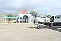
Isla Marias Airport in Nayarit, Mexico

See also
 In Spanish: Islas Marías para niños
