
Puerto Vallarta facts for kids
Quick facts for kids
Puerto Vallarta
|
|||
|---|---|---|---|

Above, from left to right: Panoramic view of Villa del Palmar, Our Lady of Guadalupe Parish, the Sea Horse Sculpture, the pier, view of the hotel zone from the boardwalk, Marina Vallarta and downtown.
|
|||
|
|||
| Nickname(s):
P.V., Vallarta
|
|||

Location of the municipality within the state of Jalisco
|
|||

Puerto Vallarta
Location in Mexico

Puerto Vallarta
Location in Jalisco
|
|||
| Country | Mexico | ||
| State | Jalisco | ||
| Municipality | Puerto Vallarta | ||
| Founded | December 12, 1851 | ||
| Founded as | Las Peñas | ||
| Named for | Ignacio Vallarta | ||
| Area | |||
| • City | 49.11 km2 (18.96 sq mi) | ||
| • Metro | 1,452 km2 (561 sq mi) | ||
| • Municipality | 680.9 km2 (262.9 sq mi) | ||
| Elevation | 7 m (23 ft) | ||
| Population
(2020 census)
|
|||
| • City | 224,166 | ||
| • Density | 4,564.6/km2 (11,822.2/sq mi) | ||
| • Metro | 479,471 | ||
| • Metro density | 330.21/km2 (855.25/sq mi) | ||
| • Municipality | 291,839 | ||
| • Municipality density | 428.61/km2 (1,110.09/sq mi) | ||
| Demonym(s) | Vallartense | ||
| Time zone | UTC−6 (Central Central Standard Time) | ||
| • Summer (DST) | UTC−6 (Central Standard Time) | ||
| Postal code |
48300
|
||
| Area code(s) | +52 322 | ||


Puerto Vallarta (pronounced PWEHR-toh vah-YAR-tah) is a popular beach city in Mexico. It is located on the Pacific Ocean in the state of Jalisco. People often call it "Vallarta" or "P.V." for short. It is the second largest city area in Jalisco, after Guadalajara.
Puerto Vallarta is named after Ignacio Vallarta, who was a governor of Jalisco. The city is also known by its airport code, PVR, which stands for Gustavo Diaz Ordaz International Airport.
Contents
History of Puerto Vallarta
The Story of Playa Los Muertos
In the 1500s, a famous explorer named Hernán Cortés sent ships to explore Mexico's Pacific coast. One of his ships crashed in Banderas Bay. Most of the sailors died. Local villagers found many bodies on the beach for days after the wreck. This is how the beach got its name, "Playa Los Muertos," which means "Beach of the Dead."
How Bahía de Banderas Got Its Name
Pirates used to attack ships along Mexico's Pacific Coast. Hernán Cortés wanted to find a safe place for cargo ships. He found a large bay near a village called Tintoque. Local stories say that pirates used this bay and buried treasure there. When Cortés and his crew arrived, villagers thought they were pirates. The villagers surrounded them with weapons.
A Catholic friar with Cortés started praying. The villagers were amazed by the red flags the crew carried. They suddenly put down their weapons. This allowed the explorers to pass peacefully. It is thought the villagers had seen these flags before. They might have floated ashore from Cortés's earlier shipwreck. This is how the bay got its name, "Bahía de Banderas," meaning "Bay of Flags."
Early History of the Area
Not much is known about the area before the 1800s. However, old tools and pottery show that people lived here as early as 580 BC. Evidence also suggests the area was part of the Aztlán culture. This culture was important in Jalisco and other states from about 900 to 1200 AD.
Founding of Las Peñas
The city of Puerto Vallarta was first founded as "Las Peñas de Santa María de Guadalupe." This happened on December 12, 1851. It was founded by Guadalupe Sánchez Torres, his wife Ambrosia Carrillo, and their friends. The name "Las Peñas" means "The Rocks." The village grew in the 1860s because of mining nearby. By 1885, it had about 800 residents.
Puerto Vallarta Becomes a Modern Resort

In the 20th century, the Mexican government invested a lot to make Puerto Vallarta a popular travel spot. They built an international airport. Roads were also greatly improved. A new port was opened in 1970. This made Puerto Vallarta Jalisco's first harbor town.
In the 1980s, many people moved to Puerto Vallarta. This caused some problems with basic services like water and roads. The government worked to fix these issues. Today, the city continues to improve its services for residents and visitors.
Geography of Puerto Vallarta

Puerto Vallarta is located on a narrow flat area next to the ocean. It sits at the base of the Sierra Madre Occidental mountains. This flat area gets wider to the north. Three rivers flow from the mountains through the city: the Cuale, the Pitillal, and the Ameca. Many small streams also run to the coast.
The city has four main parts. The "hotel zone" is along the shore to the north. South of the Cuale river is Olas Altas, also called the "Romantic Zone." The "Centro" is the downtown area between these two. There are also many neighborhoods east of the hotel zone. The oldest part of town is near the Church of Our Lady of Guadalupe.
Earthquakes in Puerto Vallarta
Puerto Vallarta is on the west coast of North America. This area can have earthquakes. However, Puerto Vallarta usually only feels smaller effects from earthquakes that happen farther south. For example, in 1995, an earthquake shook the crown off the top of the main church.
Climate and Weather
Puerto Vallarta has a tropical climate. This means it has dry winters and rainy summers. The average high temperature is about 30°C (86°F). The average low temperature is about 21°C (70°F).
The rainy season is from mid-June to mid-October. Most rain falls between July and September. Even during the rainy season, rain often comes in big storms. February, March, and April are the sunniest months.
Hurricanes do not often hit Puerto Vallarta directly. In 2002, Hurricane Kenna hit about 160 km (100 miles) northwest of the city. Puerto Vallarta had some damage from the ocean waves. In 1971, Hurricane Lily caused serious flooding. This made the city move residents from Isla Cuale to a new area.
| Jan | Feb | Mar | Apr | May | Jun | Jul | Aug | Sep | Oct | Nov | Dec |
|---|---|---|---|---|---|---|---|---|---|---|---|
| 24 °C (75 °F) | 24 °C (75 °F) | 24 °C (75 °F) | 25 °C (77 °F) | 27 °C (81 °F) | 28 °C (82 °F) | 29 °C (84 °F) | 30 °C (86 °F) | 30 °C (86 °F) | 30 °C (86 °F) | 28 °C (82 °F) | 25 °C (77 °F) |
Hurricane Patricia (2015)
Hurricane Patricia was a very powerful storm in 2015. It was one of the strongest ever recorded in the Western Hemisphere. It had winds up to 320 km/h (200 mph). Patricia was expected to hit Puerto Vallarta on October 23, 2015. People thought it would cause a lot of damage.
However, the storm weakened and hit land south of Puerto Vallarta. This saved the city from major damage. Many tourists were evacuated to Guadalajara as a safety measure.
Economy and Tourism

Most jobs in Puerto Vallarta are related to tourism. About 80% of workers are in hotels, restaurants, and transportation. Tourism is the main economic activity in the city.
Tourism Trends
Tourism in Puerto Vallarta has grown a lot over the years. The busiest time for international visitors is from late November to March. Many visitors come from the U.S. and Canada. This is because there are many direct flights to Puerto Vallarta from cities like Los Angeles, Houston, and Chicago.
Real Estate Tourism
_-_91.JPG)
Puerto Vallarta has become a popular place for people from the U.S. and Canada to retire. Many also buy second homes here. This has led to new neighborhoods built for these buyers. Areas like the Hotel Zone and Marina Vallarta are very popular. The downtown area, especially the "Romantic Zone," has also seen many new condominium buildings.
People from the United States make up about 40% of property buyers. Mexicans buy about 30%, and Canadians and others make up the rest. Mexicans like to buy property here because prices are in U.S. dollars. This can be a good investment.
If a foreigner wants to buy property near the coast in Mexico, they cannot own it directly. Instead, they use a special trust with a Mexican bank. This trust lasts for 50 years and can be renewed.
Population Growth
The city of Puerto Vallarta has grown a lot. In 1990, the city had about 93,503 people. By 2010, it had grown to 203,342 people. The larger municipality also grew from 10,801 people in 1950 to 255,725 in 2010. This growth has brought many people looking for jobs.
Transportation

The main airport is the Licenciado Gustavo Díaz Ordaz International Airport. It has flights for both international and general aviation.
Puerto Vallarta does not have passenger train service. In the past, buses connected to Tepic, where people could take trains. These trains went north to the U.S. border and east to Guadalajara and Mexico City.
Since 2017, ride-sharing services like Uber have been available in Puerto Vallarta. This has sometimes caused disagreements with local taxi drivers.
Film and Television in Puerto Vallarta
Puerto Vallarta has been featured in movies and TV shows.
- The Night of the Iguana (1963) was filmed near Puerto Vallarta. Famous actors like Richard Burton and Ava Gardner were in it. Elizabeth Taylor, who was not in the film, also visited. The movie made Puerto Vallarta famous. After filming, Elizabeth Taylor and Richard Burton bought a house here. The director, John Huston, also built a home nearby.
- The Love Boat, a popular TV show, often showed Puerto Vallarta as a port of call for its cruise ship.
- The Amazing Race 36 (2024) started its race in Puerto Vallarta.
Landmarks and Activities
Important Places in Puerto Vallarta


.jpg)
- Church of Our Lady of Guadalupe – This beautiful church is in the city center.
- Púlpito and Pilitas – These are two rock formations at the south end of Los Muertos Beach. "El Púlpito" is a tall headland, and "Las Pilitas" are rocks below it.
- Playa Conchas Chinas (Curly Shells Beach) – This is a quiet beach south of Los Muertos beach.
- The Malecón – This is a paved walkway along the ocean in downtown. It's popular for walks, especially on Sunday evenings. It has many modern sculptures by famous artists. The Malecón was rebuilt after hurricane damage in 2002-2003 and renovated in 2010.
- Mercado Isle Cuale and Mercado Municipal Río Cuale – These are two large public markets. They are located along the Cuale River and sell many handmade crafts and souvenirs.
- Cuale Archaeological Museum – This museum is on the west side of Isla Cuale. It shows a collection of ancient art from the area.
- Statue of John Huston on Isla Cuale – This statue honors the film director John Huston. It was put up 25 years after his famous movie, The Night of the Iguana, was released.
- Plaza de Armas / Aquiles Serdán Amphitheater (Los Arcos) – This is the city's main public square. It hosts concerts and events.
- City Hall – This is a modern building with a traditional courtyard. It has a tourist office and a mural by local artist Manuel Lepe.
Places South of Puerto Vallarta


- Los Arcos National Marine Park – This park is offshore from Mismaloya, about 12 km (7.5 miles) south of the city. It has been a protected area since 1984. It is a breeding ground for pelicans and other seabirds. It's also a popular spot for snorkeling.
- Vallarta Botanical Gardens – These gardens are a great place to see orchids, cacti, and other native plants. They are about 22.5 km (14 miles) south of Puerto Vallarta. Visitors can also enjoy a restaurant and swim in the river.
- Puerto Vallarta Zoo – This zoo has 350 animals and is located in a forest setting in Mismaloya.
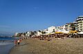
Beaches in Puerto Vallarta
- Playa Camarones (Shrimp Beach) – This is the northernmost public beach in the city. It was named after shrimp fishermen who used to unload their catch here.
- Playa Olas Altas (High Waves Beach) – This beach is south of the Cuale River. It's a popular place to swim, especially for locals. Many outdoor restaurants line the beach.
- Playa de los Muertos (Beach of the Dead) – This is the city's largest public beach. A legend says its name comes from a battle between pirates and miners. The city has tried to change its name to Playa del Sol.
Local Festivals
- Flower and Garden Festival (last week of February) – This festival at the Vallarta Botanical Gardens includes tours, classes, and workshops. Many vendors sell plants and crafts.
- Electro Beach Puerto Vallarta (starts in early March) – This is a 42-day festival featuring electronic dance music (EDM).
- May Festival (last week of May and first week of June) – This festival celebrates the city's anniversary. It has outdoor concerts, art shows, sports events, and a parade.
- Día de Muertos – Day of the Dead (November 2) – This day honors the dead in Mexican tradition at the Vallarta Botanical Gardens. It includes workshops and celebrations.
- Las Posadas (December 20) – This evening event at the Vallarta Botanical Gardens features candlelight caroling and processions to nativity scenes.
- Festival of the Virgin of Guadalupe (December 1 to 12) – This is a religious festival honoring the Virgin of Guadalupe.
Neighborhoods
Puerto Vallarta has many neighborhoods, called colonias. Some notable ones include:
- Res. Conchas Chinas – a hillside area southeast of Los Muertos beach.
- Amapas – on the hillside behind Los Muertos beach, overlooking the bay.
- Col. Emiliano Zapata – south of the Cuale River, often called the "Romantic Zone" or "Old Town."
- Col. Centro – the oldest part of town and its current center, north of the Cuale River.
- Col. 5 Diciembre – just north of the Centro, one of the first areas developed outside downtown.
- Hotel Zone – This area follows the coastline from the airport into downtown. It is full of hotels, resorts, and residential towers.
- Marina Vallarta – a large planned area near the airport with a marina, golf course, hotels, and homes.
- Del. Pitillal – once a small town, now a busy neighborhood and part of Puerto Vallarta.
The city also has many fraccionamientos, which are residential blocks that provide affordable housing for workers.
Other important towns in the municipality of Puerto Vallarta include:
Sister Cities
Puerto Vallarta has sister city relationships with:
 Highland Park, Illinois, United States
- Santa Barbara, California, United States
- McAllen, Texas, United States
Notable People
Many notable people have connections to Puerto Vallarta:
- Francisco Javier Bravo (born 1967), a politician.
- Aarón Díaz (born 1982), a Mexican American actor, singer, and model.
- Ariadne Díaz (born 1985), an actress and former model.
- Rodolfo Dickson (born 1997), a Mexican Canadian alpine skier.
- Manuel Lepe Macedo (1936–1984), a famous artist and painter.
- Natasha Moraga, an American-born Mexican tile artist.
- Marco Antonio Nazareth (1986–2009), a professional boxer.
Images for kids
-
The LGBT portion of the Playa de Los Muertos (Beach of the Dead)

See also
 In Spanish: Puerto Vallarta para niños
