
Copper Canyon facts for kids
Quick facts for kids Copper Canyon |
|
|---|---|

Copper Canyon
|
|
| Naming | |
| Native name | Barrancas del Cobre (Spanish) |
| Geography | |
| Location | Sierra Madre Occidental |
| Country | Mexico |
| State | Chihuahua |
Copper Canyon (also known as Barrancas del Cobre in Spanish) is a huge group of six different canyons in northwestern Mexico. These canyons are found in the Sierra Madre Occidental mountains, in the state of Chihuahua.
Six rivers helped create these amazing canyons. These rivers flow from the western side of the Sierra Tarahumara mountains. Eventually, all six rivers join together to form the Rio Fuerte. This big river then flows into the Gulf of California. The canyon walls often look like a mix of copper and green colors. This is how the Copper Canyon got its name!
Contents
History of Copper Canyon
People from New Spain (which is now Mexico) first arrived in the Copper Canyon area in the 1600s. They met the local people who lived all over Chihuahua. The Spanish were looking for gold and silver. They also wanted to spread Christianity.
The Spanish called the local people "Tarahumara". This name came from the word Rarámuri, which is what the local men call themselves. Some people think Rarámuri means 'The running people'. In the 1600s, the Spanish found silver in the land where the Tarahumara lived. Some Tarahumara people were made to work in the mines. They tried to resist, but it didn't work very well. Over time, they had to move away from the best lands. They went deeper into the canyon cliffs to live.

Climate in the Canyons
The weather in the high mountain parts of Copper Canyon is mild. This is especially true from October to November and from March to April. But down at the bottom of the canyons, it's usually warm and humid all year long.
From April to June, it can be very dry. There isn't much rain during these months. Then, in July, the rainy season begins. This brings much-needed water to the area.
Plants and Animals
The Sierra Tarahumara Occidental region is home to many kinds of pine and oak trees. You can find Mexican Douglas-fir trees on the high plateaus. These trees grow in areas higher than 8,000 feet (2,400 m).
Sadly, many types of wildlife are in danger because too many trees have been cut down. Cougars live in the most remote parts of the canyons. They are very hard to spot. After the summer rains, the upper areas of the canyon are filled with beautiful wildflowers until October.
Between 4,000–8,000 feet (1,200–2,400 m), you'll find huge forests of oak trees. Other trees that like shade also grow here. In the fall, the forests turn bright with colors from Andean alder and poplar trees. On the canyon slopes, you'll see brushwood and scrubby trees. These plants can handle the dry season. Down at the bottom of the canyons, where there's lots of water, huge fig and palm trees grow. The climate there is tropical.
Protecting the Ecosystem
More people living in the Sierra Tarahumara Occidental region has caused some problems for nature. Building things for tourists can sometimes harm the environment and the local cultures. New roads have been built in places that used to be hard to reach.
Farming, raising animals, and cutting down trees for wood have caused the soil to wash away easily. Trees like mesquite and desert ironwood are cut down and sent to other countries for charcoal. Amapa trees are cut for their valuable wood, used for building and furniture. Other trees are also cut and sold for their high-priced wood.
Cutting down too many trees has caused some animals to disappear forever. The imperial woodpecker and the Mexican wolf are now extinct in this area. Only about two percent of the original old forests are left.
Mining for copper, gold, and other metals also causes problems. It can pollute the air. It has also led to a big drop in the number of Tarahumara frogs. Almost every river has been blocked by a dam. This causes a lack of fresh water in nearby desert towns. A very large dam is being built on the Rio Fuerte. This could cause big environmental problems and lead to the loss of many tropical forests and animal homes.
People are working to protect the area, but it's a slow process. Mexico has laws to protect the environment. However, there isn't always enough money or staff to make sure these laws are followed. Agencies are trying hard to increase protection for natural areas.
Indigenous People
The traditional people of Copper Canyon are the Tarahumara or Rarámuri. There isn't an exact count, but there are likely between 35,000 and 70,000 Rarámuri people.
Many Rarámuri live in the cooler mountain areas during the hot summer. In the cooler winter months, they move deeper into the canyons. The climate there is milder. They have survived by living in places that are too remote for city people. This helps them stay isolated and keep their culture strong.
Tourism is growing in Copper Canyon. But local communities have different ideas about it. Some groups accept money from the government to build roads, restaurants, and places for tourists to stay. Many other Rarámuri groups prefer to live far away from city life. The mountains help protect their way of life.
Their main food comes from farming. They also eat meat from cows, chickens, and goats, as well as wild animals and fish. Corn (maize) is the most important food for the Rarámuri.
The Rarámuri people are famous for their amazing endurance running. They live in the canyons, so they often travel long distances up and down steep paths. They can run for hours without stopping. A popular Rarámuri community game is called rarajipari. Players kick a wooden ball along the steep canyon paths as they run.
Visiting Copper Canyon

There are many ways to explore Copper Canyon. You can go hiking, biking, driving, or even horseback riding. But the most popular way to see the canyons is by train. The Ferrocarril Chihuahua al Pacífico, or ChePe train, travels along the main canyon called Canyon Urique. It goes between the city of Chihuahua and Los Mochis, which is on the Gulf of California.
Building the Chihuahua al Pacifico railroad started in the late 1800s. But the revolution, a lack of money, and the difficulty of building a railroad over such tough land made it hard to finish. It wasn't completed until 1961. The railroad track is 405 miles long. It has 39 bridges and goes through 86 tunnels! The whole trip takes about 15 hours. Along the way, you pass through towns and see the towering cliffs of the canyons. Many Tarahumara people set out their food, crafts, and other items for sale along the railway.
Mexico created the Parque Nacional Barranca del Cobre (Copper Canyon National Park). This park helps protect and show off this remote area. The park is located in the areas of Batopilas, Bocoyna, Guachochi, and Urique.
The Basaseachic Falls National Park is also located within the canyon area. It is known for its beautiful Basaseachic Falls.
Images for kids
-
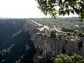
A hotel at Divisadero perches on the rim of Copper Canyon. The railroad runs nearby.

See also
 In Spanish: Barrancas del Cobre para niños
