
Pico Rivera, California facts for kids
Quick facts for kids
Pico Rivera, California
|
|||||
|---|---|---|---|---|---|

Pico Rivera City Hall
|
|||||
|
|||||

Location of Pico Rivera in Los Angeles County, California
|
|||||

Pico Rivera, California
Location in the United States
|
|||||
| Country | United States | ||||
| State | California | ||||
| County | Los Angeles | ||||
| Incorporated | January 29, 1958 | ||||
| Government | |||||
| • Type | Council–manager | ||||
| Area | |||||
| • Total | 8.88 sq mi (23.00 km2) | ||||
| • Land | 8.29 sq mi (21.48 km2) | ||||
| • Water | 0.59 sq mi (1.52 km2) 6.60% | ||||
| Elevation | 164 ft (50 m) | ||||
| Population
(2020)
|
|||||
| • Total | 62,088 | ||||
| • Density | 7,587.5/sq mi (2,887.18/km2) | ||||
| Time zone | UTC−8 (Pacific) | ||||
| • Summer (DST) | UTC−7 (PDT) | ||||
| ZIP Codes |
90660–90662
|
||||
| Area code | 562 | ||||
| FIPS code | 06-56924 | ||||
| GNIS feature ID | 1652773 | ||||


Pico Rivera is a city in southeastern Los Angeles County, California. It is about 11 miles (18 km) southeast of downtown Los Angeles. The city is on the eastern edge of the Los Angeles basin. It is also on the southern edge of the San Gabriel Valley. In 2020, about 62,088 people lived there.
Pico Rivera is next to several other cities. To the west is Montebello. To the south is Downey. Santa Fe Springs is to the southeast. And Whittier is to the east. A company called Northrop Grumman developed the B-2 Spirit bomber in Pico Rivera.
Contents
- Discovering Pico Rivera's Past
- Exploring Pico Rivera's Location
- Understanding Pico Rivera's Population
- Pico Rivera's Economy and Jobs
- Sports and Recreation in Pico Rivera
- Education in Pico Rivera
- Getting Around Pico Rivera
- Famous People from Pico Rivera
- Pico Rivera's Sister Cities
- Images for kids
- See also
Discovering Pico Rivera's Past
.jpg)

Pico Rivera became a city in 1958. It was formed by joining two older communities: Pico and Rivera. The name "Pico" comes from Pío Pico, who was the last Mexican governor of California. "Rivera" is a Spanish word meaning "riverbank."
The area is located between the Rio Hondo and the San Gabriel River. It used to be mostly farmland. After World War II, many people needed homes. Builders were drawn to the area. Since the 1950s, Pico Rivera has had both homes and factories. For many years, a Ford Motor Company plant called Los Angeles Assembly was located here.
In January 1958, people voted to make Pico Rivera an official city. They chose a Council-Manager type of government. Five citizens were elected to be the first City Council members. Pico Rivera officially became the 61st city in Los Angeles County.
Exploring Pico Rivera's Location
Pico Rivera shares borders with many cities. Downey is to the southwest. Santa Fe Springs is to the southeast. Whittier is to the east. City of Industry is to the northeast. Montebello is to the northwest. And Commerce is to the west.
A main road, Rosemead/Lakewood Boulevard (CA 19), runs through the city. The San Gabriel River Freeway (I-605) is along its southeastern edge.
The city covers about 8.88 square miles (23.00 square kilometers). Most of this is land, and a small part is water. On March 16, 2010, a 4.4 magnitude earthquake happened in Pico Rivera.
Understanding Pico Rivera's Population
| Historical population | |||
|---|---|---|---|
| Census | Pop. | %± | |
| 1960 | 49,150 | — | |
| 1970 | 54,170 | 10.2% | |
| 1980 | 53,387 | −1.4% | |
| 1990 | 59,177 | 10.8% | |
| 2000 | 63,428 | 7.2% | |
| 2010 | 62,942 | −0.8% | |
| 2020 | 62,088 | −1.4% | |
| U.S. Decennial Census | |||
Population in 2010
The 2010 United States Census showed that Pico Rivera had 62,942 people. The population density was about 7,087 people per square mile.
Most people in Pico Rivera are of Hispanic or Latino background (91.2%). Other groups include Non-Hispanic White (5.2%), Black or African American (1.0%), Native American (1.4%), and Asian (2.6%).
About 99.3% of the people lived in homes. There were 16,566 households. About 48.7% of these households had children under 18. The average household size was 3.77 people. The average family size was 4.10 people.
The population's age groups were:
- 26.7% were under 18 years old.
- 11.1% were 18 to 24 years old.
- 27.4% were 25 to 44 years old.
- 22.8% were 45 to 64 years old.
- 12.1% were 65 years or older.
The average age in Pico Rivera was 34.0 years.
There were 17,109 housing units. About 69.1% of homes were owned by the people living in them. About 30.9% of homes were rented.
Population in 2000
In the census of 2000, Pico Rivera had 63,428 people. The population density was about 7,646 people per square mile. There were 16,468 households.
The racial makeup was 49.44% White, 0.71% African American, 1.35% Native American, 2.65% Asian. About 88.29% of the population was Hispanic or Latino.
About 43.5% of households had children under 18. The average household size was 3.83 people. The average family size was 4.12 people.
The median income for a household was $41,564. For a family, it was $45,422. About 12.6% of the population lived below the poverty line.
Pico Rivera's Economy and Jobs
The Los Angeles Assembly was a large factory owned by the Ford Motor Company. It opened in 1958 and closed in 1980. In 1982, Northrop Grumman bought the site. They used it to develop the B-2 Spirit bomber. At its busiest, this project employed about 13,000 people in Pico Rivera. The site closed in 2001 and became a large shopping center.
The city has seen a lot of new development. The Pico Rivera Towne Center is a large outdoor shopping area. It brought many new businesses to the city. "Pico Crossing" is another shopping center with several national stores.
Other new developments include the "Pico Rivera Village Walk." This is a $22 million shopping center. The "Pico Rivera Market Place Shopping Center" has also opened.
Top Employers in Pico Rivera
Many people in Pico Rivera work for these companies and organizations.
Top Employers in 2019
| # | Employer | # of Employees |
|---|---|---|
| 1 | El Rancho Unified School District | 1,225 |
| 2 | Walmart | 497 |
| 3 | Target | 191 |
| 4 | Feit Electric Co Inc | 189 |
| 5 | Lowe's | 187 |
| 6 | Rivera Nursing & Convalescent | 182 |
| 7 | Bay Cities Container | 160 |
| 8 | Aurora World, Inc | 136 |
| 9 | El Rancho Vista Healthcare Center | 112 |
| 10 | Anastasia Beverly Hills Inc | 100 |
Sports and Recreation in Pico Rivera
The north side of the city has the Pico Rivera Sports Arena. This is where concerts and other events are held.
Parks and Fun Places
Pico Rivera has nine parks and eight playgrounds. Some of these include Smith Park, Rivera Park, Pico Park, Rio Vista Park, and Stream Land Park. The city has over 120 acres of public recreation areas. There are 18 sports fields, two gyms, and four community centers. There is also a golf course, a skatepark, and an aquatic center.
Pico Rivera Municipal Golf Course
The Pico Rivera Municipal Golf Course was built in 1965. It is a nine-hole course. It has practice areas like putting greens and a driving range. Lights allow people to play and practice until 10:00 p.m.
Senior Center
Pico Rivera has a newly renovated senior center. It has a computer lab with 16 computers. There is also a modern dance room. The fitness room has 18 exercise machines and TVs. The billiard room has four new pool tables. This center helps older residents stay active and connected.
Education in Pico Rivera
The city is served by two school districts: El Rancho Unified School District and Montebello Unified School District. Most students go to schools in the El Rancho Unified School District.
The Armenian Mesrobian School is a private K-12 Armenian school. It is also located in Pico Rivera. For higher education, there are universities and colleges nearby in Los Angeles and Orange counties.
Getting Around Pico Rivera
Pico Rivera is easy to reach because of its central location. Several freeways are nearby, including the San Gabriel (605), Santa Ana (5), and Pomona (60) freeways.
Public transportation is available through the Metropolitan Transportation Authority (MTA) and Montebello Bus Lines. There is also a "Dial-a-Ride" service for elderly and disabled residents.
Main roads that run north-south include Rosemead Boulevard, Paramount Boulevard, and Passons Boulevard. Main roads that run west-east include Whittier Boulevard, Slauson Avenue, Washington Boulevard, Beverly Boulevard, and Telegraph Road.
Famous People from Pico Rivera
- Jennifer Syme, an actress.
- Actress Lupe Ontiveros lived in Pico Rivera for a long time.
- Singer Jeanette Jurado from the group Exposé grew up in Pico Rivera.
- Baseball player Randy Flores went to El Rancho High School. He was part of the 2006 World Series winning team.
- Soccer player Cristian Roldan plays for the Seattle Sounders FC. He graduated from El Rancho High School in 2013.
- James C. Shugg built the first schoolhouse, the Rivera School, in 1868.
- Gloria Molina (1948–2023) was an American politician.
Pico Rivera's Sister Cities
Pico Rivera has special connections with cities in Mexico. These are called "sister cities."
 San Luis Potosi (city), Mexico
- Mazatlan, Mexico
- Tlajomulco de Zúñiga, Mexico
- Chapala, Jalisco, Mexico
Images for kids
-
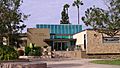
Pico Rivera City Hall
-

Flag of Pico Rivera
-
Seal of Pico Rivera
-

Logo of Pico Rivera
-
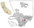
Location of Pico Rivera in Los Angeles County, California
See also
 In Spanish: Pico Rivera para niños
