
Interstate 605 facts for kids
Quick facts for kids
|
||||
|---|---|---|---|---|
| San Gabriel River Freeway | ||||
| Lua error in Module:Infobox_road/map at line 15: attempt to index field 'wikibase' (a nil value).
I-605 highlighted in red
|
||||
| Route information | ||||
| Auxiliary route of I-5 | ||||
| Defined by S&HC § 619 | ||||
| Maintained by Caltrans | ||||
| Length | 27.40 mi (44.10 km) | |||
| History | 1940s as a state highway, 1964 as a number | |||
| Major junctions | ||||
| South end | ||||
|
||||
| North end | ||||
| Location | ||||
| Counties: | Orange, Los Angeles | |||
| Highway system | ||||
| Auxiliary route of the Interstate Highway System Main • Auxiliary • Business State highways in California(list • pre-1964)
|
||||
.svg)
Interstate 605 (I-605), also called the San Gabriel River Freeway, is an important highway in California. It runs through Orange County and Los Angeles County. This highway is a "spur route," which means it branches off from a main Interstate. I-605 connects with Interstate 5.
The freeway starts in Seal Beach at Interstate 405. It then travels north, following the San Gabriel River for most of its journey. The highway ends in Duarte at Interstate 210. The entire route is about 27 miles (43 kilometers) long.
Contents
What is Interstate 605?
Interstate 605 is part of the Interstate Highway System. This system is a network of major roads across the United States. I-605 helps people travel between different cities in Southern California. It's a busy road used by many cars and trucks every day.
Where Does I-605 Go?
I-605 connects many cities and other major highways. As it travels north, it passes through places like Cerritos, Norwalk, and Whittier. It also crosses several other important freeways. These include State Route 91, Interstate 105, and Interstate 10.
The freeway is named the San Gabriel River Freeway because it runs right next to the San Gabriel River. This river flows through the San Gabriel Valley.
History of the San Gabriel River Freeway
The idea for this highway started in the 1940s as a state highway. Over time, it was planned to be a major freeway. In 1964, it officially became known as Interstate 605. Since then, it has been a key route for commuters and travelers in the area. It helps people get to work, school, and other places.
Images for kids
-
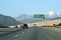
Approaching the northern terminus of I-605

See also
 In Spanish: Interestatal 605 para niños
