Cerritos, California facts for kids
Quick facts for kids
Cerritos, California
|
|||
|---|---|---|---|
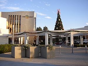
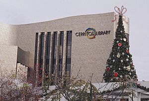
Cerritos Library in 2004
|
|||
|
|||
| Motto(s):
"A City With Vision", "Progress Through Commitment", "A History In Progress", "A Prestige Address"
|
|||
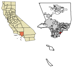
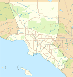
Location of Cerritos in Los Angeles County, California.
|
|||
| Country | United States | ||
| State | California | ||
| County | Los Angeles | ||
| Incorporated | April 24, 1956 | ||
| Government | |||
| • Type | Council–manager | ||
| • Body |
City council
Lynda P. Johnson
Chuong Vo Frank Aurelio Yokoyama |
||
| Area | |||
| • Total | 8.86 sq mi (22.94 km2) | ||
| • Land | 8.73 sq mi (22.60 km2) | ||
| • Water | 0.13 sq mi (0.34 km2) 1.48% | ||
| Elevation | 46 ft (14 m) | ||
| Population
(2020)
|
|||
| • Total | 49,578 | ||
| • Density | 5,680.99/sq mi (2,193.45/km2) | ||
| Time zone | UTC−8 (Pacific) | ||
| • Summer (DST) | UTC−7 (PDT) | ||
| ZIP Codes |
90701, 90703
|
||
| Area code | 562 | ||
| FIPS code | 06-12552 | ||
| GNIS feature IDs | 241229, 2409431 | ||
Cerritos (/səˈriːtoʊz/) is a city in Los Angeles County, California, United States. Its name means "Little hills" in Spanish. It's one of the "Gateway Cities" in southeast Los Angeles County. The city became official on April 24, 1956. In 2019, about 49,859 people lived there. Cerritos is part of the larger Los Angeles–Long Beach–Anaheim area.
Contents
History of Cerritos
Long ago, the land where Cerritos is now was home to Native Americans called the Tongva people. The Spanish settlers later called them "Gabrieleños." The Tongva were the largest and most advanced group of native people in Southern California. They lived off the land, gathering plants, hunting animals, and grinding acorns for food.
Spanish explorers arrived in California in 1542. They started building missions to "civilize" the native people. Later, the city of Los Angeles was founded and grew with help from people from New Spain and Native American workers.
A Spanish soldier named José Manuel Nieto received a huge piece of land from the Spanish King. He named it Rancho Los Nietos. This rancho was enormous, covering about 300,000 acres. Today, many cities like Cerritos, Long Beach, and Downey are on this land.
Later, the rancho was divided among Nieto's family. One part, called Rancho Los Coyotes, was kept by Juan José Nieto. He called a part of Rancho Los Coyotes "cerritos" or "little hills."
After the Mexican-American War, the land changed hands. It eventually became part of a company that helped build railroads. This led to the growth of modern-day Artesia in 1875. From Artesia, the city of Dairy Valley was formed.
A small airport called Cranford Airport was built around 1946. It had two runways. This airport closed between 1953 and 1954.
From Dairy Valley to Cerritos
The city of Dairy Valley was officially created on April 24, 1956. It was named this because it had over 400 dairies, 100,000 cows, and 106,300 chickens! The cows outnumbered the people by 29 to 1.
As land became more valuable in the 1960s, farming became less profitable. People wanted to build homes instead. So, in 1963, residents voted to allow large housing developments. To show its new focus on homes, the city's name was changed to Cerritos on January 10, 1967. It was named after the historic Rancho Los Cerritos and Cerritos College.
Cerritos became a leader in how cities could make money. After a law called Proposition 13, cities needed to create more shopping areas to collect sales tax. Cerritos was one of the first cities in Los Angeles County to build big shopping centers like the Los Cerritos Center and Cerritos Auto Square. The money from these businesses helped the city build great public facilities and offer many community programs.
Cerritos has many impressive public buildings. In 1978, it opened the first solar-heated City Hall in the country. The Cerritos Center for the Performing Arts opened in 1993. In 1994, the Cerritos Towne Center opened, combining offices, shops, hotels, and restaurants. The public library was updated in 2002. In 2006, the city celebrated its 50th birthday with a new sculpture garden.
Between 1970 and 1972, Cerritos was the fastest-growing city in California. Its population jumped from 16,000 to 38,000. Since the 1980s, many families from the Philippines, Korea, Taiwan, India, and China have moved to Cerritos.
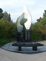
On August 31, 1986, a sad event happened. A passenger plane, Aeroméxico Flight 498, crashed into a residential area of Cerritos after hitting a small plane. This accident caused the death of 82 people, including 15 on the ground. A sculpture in the Cerritos Sculpture Garden remembers this event.
Geography of Cerritos
Cerritos covers about 8.9 square miles (22.9 square kilometers). Most of this area is land, with a small part being water.
The city is located right on the border between Los Angeles County and Orange County. Neighboring cities in Los Angeles County include Artesia, Lakewood, and Norwalk. On the Orange County side, it borders Buena Park and La Palma.
The postal code for Cerritos used to be 90701, shared with Artesia. But in the mid-1990s, it changed to the unique 90703 because the city was growing so much.
Climate in Cerritos
| Weather chart for Cerritos, California | |||||||||||||||||||||||||||||||||||||||||||||||
|---|---|---|---|---|---|---|---|---|---|---|---|---|---|---|---|---|---|---|---|---|---|---|---|---|---|---|---|---|---|---|---|---|---|---|---|---|---|---|---|---|---|---|---|---|---|---|---|
| J | F | M | A | M | J | J | A | S | O | N | D | ||||||||||||||||||||||||||||||||||||
|
3
68
46
|
3
68
48
|
2.4
69
50
|
0.6
73
53
|
0.2
74
58
|
0.1
78
61
|
0
83
65
|
0.1
85
66
|
0.2
83
64
|
0.4
79
58
|
1.1
73
50
|
1.8
69
45
|
||||||||||||||||||||||||||||||||||||
| temperatures in °F precipitation totals in inches source: Weather.com / NWS |
|||||||||||||||||||||||||||||||||||||||||||||||
|
Metric conversion
|
|||||||||||||||||||||||||||||||||||||||||||||||
Cerritos has a Mediterranean climate. This means summers are warm to hot, and winters are mild. It rarely gets cold enough for freezing temperatures. Most of the rain falls during the winter months.
Cerritos also has a special "semi-marine" climate. The ocean breeze from the San Gabriel River helps keep the city cooler. This means Cerritos usually avoids the heavy smog, strong Santa Ana winds, and very hot temperatures that affect other parts of the Los Angeles Basin.
People of Cerritos
| Historical population | |||
|---|---|---|---|
| Census | Pop. | %± | |
| 1880 | 166 | — | |
| 1960 | 3,508 | — | |
| 1970 | 15,856 | 352.0% | |
| 1980 | 53,020 | 234.4% | |
| 1990 | 53,240 | 0.4% | |
| 2000 | 51,488 | −3.3% | |
| 2010 | 49,041 | −4.8% | |
| 2020 | 49,578 | 1.1% | |
| 2022 (est.) | 47,475 | −3.2% | |
| U.S. Decennial Census | |||
In 2010, the population of Cerritos was 49,041 people. The city is very diverse. Many residents are of Asian background, including people from Korea, the Philippines, Taiwan, India, and China. There are also many White, African-American, and Hispanic or Latino residents.
The average household in Cerritos has about 3.15 people. Many families with children live in the city. The median age in Cerritos is 44 years old. Most people in Cerritos own their homes. The city has a good median household income.
Economy in Cerritos
Cerritos gets most of its money from sales tax and interest from its funds. This money helps the city provide services and build new projects.
The main places for jobs in Cerritos are the Los Cerritos Shopping Center and the Cerritos Industrial Park. The Industrial Park has businesses that make electronic and car parts. United Parcel Service (UPS) is the biggest employer in the city, with 6,000 workers. The Los Cerritos Center and the Cerritos Auto Square also provide many jobs.
Cerritos residents are known for spending a lot on retail. People from all over Southern California, including Orange County, come to Cerritos to shop, especially for cars.
Cerritos Auto Square
The Cerritos Auto Square is a huge area where all the car dealerships in Cerritos are grouped together. It's easy to reach from two major freeways.
Los Cerritos Center
The Los Cerritos Center is a large shopping mall that opened in 1971. It's the city's biggest source of sales tax money.
Cerritos Towne Center
The Cerritos Towne Center is a modern area that combines offices, shops, a hotel, and entertainment. It includes the Cerritos Center for the Performing Arts and a Sheraton hotel. It's a great place to work, shop, or enjoy a show.
Top Employers
Here are some of the largest employers in Cerritos:
| Rank | Employer | Number of Employees |
|---|---|---|
| 1 | United Parcel Service | 6,000 |
| 2 | ABC Unified School District | 3,500 |
| 3 | AT&T | 1,200 |
| 4 | Southern Wine & Spirits of Southern California | 1,100 |
| 5 | City of Cerritos | 552 |
| 6 | Crown Bolt | 400 |
| 7 | Nordstrom | 400 |
| 8 | College Hospital | 400 |
| 9 | PMI | 350 |
| 10 | Norm Reeves Honda of Cerritos | 350 |
Arts and Culture in Cerritos
Cerritos has an "Art in Public Places Program." This program asks artists to create sculptures and fountains to be displayed around the city. The Los Cerritos Community News is a local newspaper that serves the city.
Tournament of Roses Parade
Since 2002, the City of Cerritos has taken part in the famous Tournament of Roses Parade. This parade happens every New Year's Day in Pasadena. Cerritos creates its own special floats for the parade.
Cerritos Center for the Performing Arts
The Cerritos Center for the Performing Arts (CCPA) is a fantastic place to see live shows. It hosts music, magic, comedy, dance, and plays. The building is very special because its seats, floors, and stage can move! This allows the theater to change into six different sizes, holding from 921 to 1,800 people.
The CCPA opened on January 9, 1993, with a four-day performance by Frank Sinatra. It has won several awards for its design and is one of the top-earning theaters in the United States.
Cerritos Millennium Library
The Cerritos Library first opened in 1973. It was renovated in 2002 and renamed the Cerritos Millennium Library. It was the first building in North America to be covered in titanium panels! This $40 million library has amazing interior designs with themed reading rooms.
The Cerritos Library is connected to the Smithsonian museums. It has won awards for its design and was named "Best Library" by Reader's Digest in 2004.
Cerritos Sculpture Garden
The Cerritos Sculpture Garden opened on March 11, 2006. It's located in the Civic Center and is designed to hold about 20 sculptures. When it opened, three sculptures were already there:
- The Air Disaster Memorial: This sculpture honors everyone who died in the Aeroméxico Flight 498 plane crash in 1986.
- A replica of the Statue of Freedom: This is a copy of the statue on top of the United States Capitol dome.
- Elements Fountain: This fountain shows female figures representing the four elements: earth, water, wind, and fire.
The garden is a beautiful place with lots of plants and space for more art in the future.
Parks and Recreation in Cerritos
Cerritos Olympic Swim & Fitness Center
The Cerritos Olympic Swim & Fitness Center is an indoor facility for swimming and fitness. It's open all year round for fun, lessons, and competitions. Olympic swimmers even used this center for practice during the 1984 Summer Olympics in Los Angeles!
Pat Nixon Park
Pat Nixon Park is a park that honors Pat Nixon, who was the First Lady and wife of President Richard Nixon. Her childhood home used to be on this spot, but it burned down in 1978. The park also has a modern senior center for older adults.
Community and Neighborhood Parks
Heritage Park is a community park in the middle of the city. It celebrates the American Revolutionary War and the founding of the United States. It has a fun play island with a colonial theme and a moat.
Liberty Park, on the west side of town, was updated in 2005. It has a community center, a fitness center, a jogging track, and a playground. There's also an outdoor amphitheater for kids called Camp Liberty.
Don Knabe Community Regional Park includes the Cerritos Sports Complex, a skate park, and outdoor swimming pools. It even has an artificial lake with fish!
Cerritos also has 18 smaller neighborhood parks, an executive golf course, and two school gyms that the community can use.
Education in Cerritos
Public Schools
Most of Cerritos is served by the ABC Unified School District. A small part on the west side of the city is part of the Bellflower Unified School District.
Kids in the ABCUSD part of Cerritos go to elementary school (Kindergarten to 6th grade), then middle school (7th and 8th grade), and then high school (9th to 12th grade). However, some students can attend Whitney High School, which covers 7th to 12th grade. Whitney High School is known as one of the best schools in California.
Private Schools
Valley Christian High School is one of the largest private Protestant schools in Los Angeles County.
Colleges and Universities
Cerritos is also home to Cerritos College and Fremont College.
Education Levels
A large number of high school graduates from Cerritos (85%) go on to higher education. Many residents have college degrees, with 26% holding a bachelor's degree and 11% having an advanced degree.
Transportation in Cerritos
Cerritos has its own fleet of buses called the Cerritos On Wheels (or COW). These buses have stops all over town. The name "COW" is a fun nod to the city's past as Dairy Valley, when cows were everywhere! These buses use propane fuel and offer Wi-Fi. They also connect to other bus systems like Long Beach Transit.
For disabled and elderly residents, the city offers a special Dial-A-Ride service.
Cerritos is easy to reach because three major California freeways pass through or near it:
- SR 91 (the Artesia Freeway) goes through the middle of the city.
- Interstate 605 (the San Gabriel River Freeway) runs along the west side.
- Interstate 5 (the Santa Ana Freeway) is close to the northeast border.
Major roads in Cerritos include Alondra Boulevard, Artesia Boulevard, and South Street.
The nearby Port of Los Angeles and Port of Long Beach are very important for shipping goods in and out of the country.
For air travel, residents can use several airports, including Los Angeles International Airport (LAX), John Wayne Airport in Orange County, and Long Beach Municipal Airport.
Famous People from Cerritos
Many notable people have lived in or are from Cerritos:
- Troy Aikman: A famous American football quarterback for the Dallas Cowboys.
- Marcelo Balboa: A professional soccer player for the MLS Colorado Rapids and the US national team.
- Johnny Chan: A professional poker player.
- Morris Chestnut: An actor.
- Robby Gordon: A NASCAR race car driver.
- Jimmy Kim: An Olympic gold medalist in taekwondo.
- Eddie Lewis: A professional soccer player.
- Roger Lodge: A TV host and radio sports announcer.
- Shane Mack: A former MLB baseball player.
- Justin H. Min: An actor.
- Pat Nixon: Former First Lady of the United States. Her childhood home is now Pat Nixon Park.
- Max Park: A world-record holder in solving the Rubik's Cube.
- Lela Rochon: An actress.
- Jae Park: A solo music artist and former member of the band DAY6.
- Kirsten Vangsness: An actress and writer.
- Jim Zorn: A former NFL coach and quarterback.
- Malaka Gharib: A writer, journalist, and cartoonist.
- Chad Allen: An actor.
Sister Cities
Cerritos has one sister city:
 Itapetinga, Bahia, Brazil
See also
 In Spanish: Cerritos (California) para niños
 | DeHart Hubbard |
 | Wilma Rudolph |
 | Jesse Owens |
 | Jackie Joyner-Kersee |
 | Major Taylor |


