Artesia, California facts for kids
Quick facts for kids
Artesia, California
|
|||
|---|---|---|---|

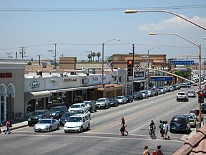
Pioneer Boulevard in Artesia, California
|
|||
|
|||

Location of Artesia in Los Angeles County, California.
|
|||
| Country | |||
| State | |||
| County | Los Angeles | ||
| Incorporated | May 29, 1959 | ||
| Named for | the local artesian wells | ||
| Government | |||
| • Type | council-manager government | ||
| Area | |||
| • Total | 1.62 sq mi (4.20 km2) | ||
| • Land | 1.62 sq mi (4.20 km2) | ||
| • Water | 0.00 sq mi (0.00 km2) 0% | ||
| Elevation | 52 ft (16 m) | ||
| Population
(2020)
|
|||
| • Total | 16,395 | ||
| • Density | 10,120.37/sq mi (3,906.37/km2) | ||
| Time zone | UTC-8 (PST) | ||
| • Summer (DST) | UTC-7 (PDT) | ||
| ZIP codes |
90701
|
||
| Area code(s) | 562 | ||
| FIPS code | 06-02896 | ||
| GNIS feature IDs | 1660272, 2409735 | ||
Artesia is a city in southeast Los Angeles County, California. Its name comes from the Spanish word for "artesian aquifer". An artesian aquifer is a natural underground water source.
Artesia became an official city on May 29, 1959. It is one of the "Gateway Cities" in Los Angeles County. In 2010, about 16,522 people lived there. The city is surrounded by Cerritos on three sides and Norwalk to the north.
Artesia is home to the East West Ice Palace. This ice rink is partly owned by famous figure skater Michelle Kwan. Also, former First Lady Pat Nixon grew up here from 1914 to 1931. The land where she lived is now part of nearby Cerritos.
Contents
History of Artesia
The village of Artesia began on May 3, 1875. This was when the Artesia School District was finished. The area was named Artesia because it had many natural artesian wells. These wells provided water, making the land great for farming.
In the 1920s and 1930s, farmers from the Netherlands and Portugal helped Artesia grow. It became a very important area for dairy farming in Southern California.
After World War II, more people wanted to live in the area. Developers started building many houses. Because of this, many dairy farmers moved their businesses. They went to places like Chino and the Central Valley. Artesia officially became a city on May 29, 1959.
Before Artesia was a city, some nearby rural areas used "Artesia" as their mailing address. This included places like Hawaiian Gardens.
In 1993, the Artesia Historical Society was created. Its goal is to save old records and important historical places in the city. In 2002, the Historical Society saved an old Spanish-style home. They turned it into a museum that is open to the public.
City Characteristics
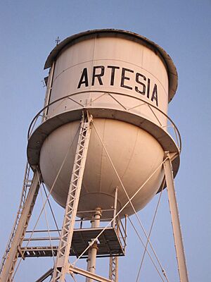
Artesia Water Tower
The Artesia water tower is a well-known landmark in the city. Not much is known about its early history or when it was built. The City of Artesia is working to have the tower recognized as a historical Landmark. They are asking citizens for old photos and information about the tower.
International and Cultural Shopping District
Pioneer Boulevard in Artesia has many stores and restaurants owned by people of Indian heritage. Even with many Indian-owned businesses, only about 7.9% of Artesia's population was Asian Indian in 2010.
There have been ideas to call part of the city "Little India". This would be similar to "Little Saigon" in nearby Westminster. Another idea was to put a "Little India" sign on the Artesia Freeway exit. However, some people in the city, especially those from other backgrounds, did not agree with these plans.
According to a Los Angeles Times article, city leaders were upset about attempts to name the area "Little India" without their input. The city council won a bill that requires local approval for freeway signs. The mayor at the time, Larry Nelson, pointed out that East Asian markets were more common than Indian ones. Because of this, the area is now called the "International and Cultural Shopping District."
Geography of Artesia
Artesia is located at 33°52′2″N 118°4′50″W / 33.86722°N 118.08056°W.
The United States Census Bureau says the city covers about 1.6 square miles (4.2 square kilometers). All of this area is land.
Population and People
| Historical population | |||
|---|---|---|---|
| Census | Pop. | %± | |
| 1950 | 3,223 | — | |
| 1960 | 9,993 | 210.1% | |
| 1970 | 14,757 | 47.7% | |
| 1980 | 14,301 | −3.1% | |
| 1990 | 15,464 | 8.1% | |
| 2000 | 16,380 | 5.9% | |
| 2010 | 16,522 | 0.9% | |
| 2020 | 16,395 | −0.8% | |
| U.S. Decennial Census | |||
Population in 2010
In the 2010 census, Artesia had 16,522 people. The city had about 10,195 people per square mile. Most people lived in homes, while a small number lived in group housing or institutions.
The census showed that 39.0% of the population was White. About 37.1% were Asian, and 15.9% were from other races. People of Hispanic or Latino background made up 35.8% of the population.
There were 4,535 households in Artesia. About 42.6% of these homes had children under 18. The average household had 3.51 people. The average family had 3.80 people.
The median age in Artesia was 38.2 years. About 22.5% of the people were under 18. About 13.6% were 65 or older.
Most homes were owned by the people living in them (55.6%). The rest were rented (44.4%).
In 2010, the average household income in Artesia was $59,845. About 13.5% of the people lived below the federal poverty line.
Population in 2000
In the 2000 census, Artesia had 16,380 people. The population density was about 10,126 people per square mile.
The racial makeup of the city was 44.18% White and 27.41% Asian. About 38.29% of the population was Hispanic or Latino.
About 40.7% of households had children under 18. The average household size was 3.54 people. The average family size was 3.87 people.
The median age was 34 years. About 27.2% of the people were under 18. About 12.4% were 65 or older.
The average household income was $44,500. The average family income was $47,017. About 11.5% of the population lived below the poverty line.
Ancestry and Ethnicity
About 45.8% of people in Artesia were born in another country.
For people of European background, 9.4% of Artesia's residents have Portuguese ancestry. Dutch is the next most common European ancestry at 4.6%.
About 27.4% of Artesia's population has Asian ancestry. The most common Asian backgrounds are Filipino (10.4%), Chinese (5.1%), Indian (4.6%), and Korean (4.5%).
About 3.6% of Artesia's population is Black or African American.
About 38.3% of Artesia's population is Hispanic or Latino. Most of these people are of Mexican descent (32.4%).
According to Mapping L.A., Mexican and Filipino were the most common ancestries in 2000. Mexico and the Philippines were also the most common countries of birth for foreign-born residents.
Education in Artesia
Students in Artesia attend schools that are part of the ABC Unified School District.
City Services
Fire protection in Artesia is handled by the Los Angeles County Fire Department. Ambulance services are provided by Care Ambulance Service.
The Los Angeles County Sheriff's Department has a station in Lakewood that serves Artesia.
The Los Angeles County Department of Health Services operates the Whittier Health Center in Whittier, which serves Artesia residents.
The United States Postal Service Artesia Post Office is located at 11721 183rd Street. The local newspaper that serves the city is called Los Cerritos Community News.
See also
 In Spanish: Artesia (California) para niños
 | Tommie Smith |
 | Simone Manuel |
 | Shani Davis |
 | Simone Biles |
 | Alice Coachman |


