Santa Ana winds facts for kids

The Santa Ana winds, sometimes called the devil winds, are strong, very dry winds. They blow from inland areas across Southern California and northern Baja California. These winds start from cool, dry air masses in the Great Basin region.
Santa Ana winds are famous for bringing hot, dry weather. This often happens in autumn, making it the hottest time of the year. They can also happen at other times. These winds bring the lowest humidity of the year to coastal Southern California. They also create "beautifully clear skies."
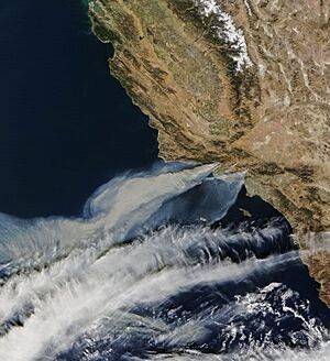
The low humidity, warm air, and strong winds create dangerous conditions. They can quickly spread destructive wildfires.
About 10 to 25 Santa Ana wind events happen each year. A Santa Ana wind can blow for one to seven days. On average, an event lasts three days. The longest one recorded was 14 days in November 1957. Strong winds often cause damage in places like the Santa Ana River basin in Orange County. They also affect the Santa Clara River basin in Ventura and Los Angeles County. Other affected areas include Newhall Pass and Cajon Pass.
The Santa Ana Winds cause most wildfires in Southern California. For example, the winds were a major force behind the January 2025 Southern California wildfires. These fires happened on and off for 24 days, from January 6 to January 31, 2025.
Contents
What Are Santa Ana Winds?
How Santa Ana Winds Form
Santa Ana winds are a type of wind called katabatic winds. This means they flow downhill from higher places towards sea level. The National Weather Service describes them as "strong, hot, dust-bearing winds." They blow from inland desert regions to the Pacific Coast near Los Angeles.

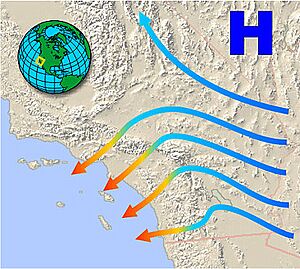
Santa Ana winds begin with high-pressure air over the Great Basin and upper Mojave Desert. If there's a low-pressure area over the Pacific Ocean, it can pull this high-pressure air. This creates a "pressure gradient," like a slope for air. The air then flows south down the eastern side of the Sierra Nevada mountains. It then moves into Southern California.
Forecasters often check the pressure difference between Los Angeles International Airport and Las Vegas. A difference of 9 millibars (0.27 inches of mercury) is usually enough for a Santa Ana event. Dry air spirals out clockwise from the high-pressure center. This dry air moves across the deserts of eastern California towards the coast. It then hits the tall Transverse Ranges mountains.
The air takes the easiest path through mountain passes to reach the lower coastal areas. This is because the low-pressure area offshore pulls the air.
Passes like Soledad Pass, Cajon Pass, and San Gorgonio Pass funnel these winds. This makes the winds speed up, often reaching near-gale force or stronger. This speed increase is due to the Venturi effect. It's like when water speeds up in a narrow hose.
As the air moves downhill, it gets warmer and its pressure increases. It warms about 5 degrees Fahrenheit for every 1,000 feet it drops. This warming also makes the air much drier. The air is already dry from crossing mountains and sinking from high in the atmosphere. So, its humidity often drops below 10 percent.
The result is a strong, warm, and very dry wind. It blows out of mountain passes into valleys and coastal plains. These winds can easily go over 40 miles per hour. They can make brush or forest fires much worse, especially during dry conditions.
During Santa Ana conditions, it's usually hotter along the coast than in the deserts. Coastal Southern California often sees its highest temperatures in autumn, not summer. Very cold, dry air from Canada can create the strongest Santa Ana winds.

Santa Ana winds are katabatic, meaning they flow downhill. However, they are not Föhn winds. Föhn winds get warmer because of rain on one side of a mountain. This releases heat, making the air warmer on the other side. An example is the Chinook wind.
If Santa Ana winds are strong, the usual daytime sea breeze might not happen. Or it might be very weak later in the day. This is because the strong offshore desert winds push against the sea breeze. At night, Santa Ana winds combine with the land breeze. This makes them even stronger. This happens because inland deserts cool more than the ocean at night.
People often link Santa Ana winds with hot, dry weather. But cold Santa Anas also exist. These cold winds are often linked to the strongest wind speeds across the region.
How Santa Ana Winds Affect the Region

Santa Ana winds often bring the lowest humidity of the year to coastal Southern California. This low humidity, combined with warm air and high wind speeds, creates dangerous fire conditions. The mix of wind, heat, and dryness turns the chaparral plants into explosive fuel. This feeds the famous wildfires that the region is known for.
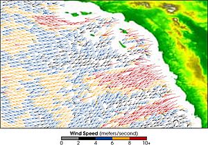
Even though these winds can be destructive, they also have some benefits. They cause cold water to rise from deep in the ocean. This brings many nutrients to the surface. These nutrients help local fish populations. When the winds blow over the ocean, sea surface temperatures drop about 4 degrees Celsius (7 degrees Fahrenheit). This shows the upwelling of cold water. The amount of chlorophyll in the surface water also increases a lot. This shows more tiny ocean plants are growing.
How Santa Ana Winds Affect Boats
During Santa Ana winds, large ocean waves can form. These waves come from the northeast. They hit the normally protected sides of the Channel Islands. This includes popular places like Catalina and Santa Cruz islands. Harbors and anchorages that are usually safe, like Avalon and Two Harbors, can get high surf and strong winds. These winds can even pull boats from their moorings. When Santa Ana conditions are present, boaters are advised to moor on the southern side of affected islands or return to the mainland.
Other Similar Winds
Santa Ana Fog
A Santa Ana fog happens after a Santa Ana wind event ends. It's a ground fog that settles in coastal Southern California. When Santa Ana winds are blowing, the air over the coast is very dry. This dry air also extends over the ocean. When the Santa Ana winds stop, cool and moist air from the ocean can quickly return. This creates very moist air and low clouds or fog. If the winds then blow onshore, this sea fog moves onto coastal areas.
This causes a sudden change from hot, dry Santa Ana conditions to cool, moist, and gray marine weather. The Santa Ana fog can cover cities in as little as fifteen minutes. However, a true Santa Ana fog is rare. It needs specific conditions for the ocean air to return quickly and for winds to switch from offshore to onshore. More often, the high-pressure system that caused the Santa Anas weakens slowly. In this case, the winds stop, but warm, dry conditions can continue for days or weeks.
A similar thing happens when Santa Ana conditions are weak. Hot, dry air builds up in inland valleys but doesn't reach sea level. People driving from the sunny, warm San Fernando Valley might cross the Santa Monica Mountains. Then they suddenly enter cool, cloudy air and fog from the ocean. This is an example of an air inversion.
Sundowner Winds
Similar winds happen in the Santa Barbara and Goleta areas. They occur most often in late spring to early summer. They are strongest at sunset, which is why they are called "sundowner" winds. High-pressure areas usually move east. This changes the pressure in Southern California to the northeast. So, "sundowner" wind events often happen a day or two before Santa Ana events.
History of Santa Ana Winds

Santa Ana winds and the wildfires they cause have been part of the Los Angeles Basin for over 5,000 years. This dates back to the first people living there, like the Tongva and Tataviam peoples. People have written about Santa Ana winds in Southern California since at least the mid-1800s. During the Mexican–American War in January 1847, Commodore Robert Stockton reported a "strange, dust-laden windstorm."
Over time, these hot, dry winds have been called dust storms, hurricane-force winds, and violent north-easters. They damaged houses and destroyed fruit orchards. Old newspaper photos show damage from these winds. When the Los Angeles Basin was mostly farms, farmers especially feared the winds. They could destroy crops.
The strongest Santa Ana winds ever recorded happened in early December 2011. In Pasadena and Altadena, winds blew steadily at 97 miles per hour. Gusts reached up to 167 miles per hour. Mammoth Mountain had a near-record wind gust of 175 miles per hour on December 1, 2011.
Wildfires Caused by Santa Ana Winds
Santa Ana winds are "gusty" and "drying." This makes them very dangerous for wildfires in the region. These winds have been linked to some of the biggest and deadliest wildfires in California.

Major fires fueled by Santa Ana winds before 2000 include the Santiago Canyon Fire (1889), Bel Air Fire (1961), and Laguna Fire (1970, 1993).
From 2000 to 2019, major Santa Ana-fueled fires included the Cedar Fire (2003) and Old Fire (2003). Also, the Witch Creek Fire (2007) and Thomas Fire (2018) were very large.
More recently, from 2020 to the present, fires like the El Dorado Fire (2020) and Bobcat Fire (2020) were made worse by these winds. The Santa Ana winds greatly worsened a series of wildfires in January 2025. These included the Eaton Fire and the Palisades Fire. These fires burned over 35,000 acres and killed 24 people. The winds reached over 80 miles per hour in some areas, similar to a Category 1 hurricane.
Health Effects of Santa Ana Winds
The winds can carry tiny spores of fungi called Coccidioides immitis and Coccidioides posadasii. These fungi cause a disease called Coccidioidomycosis, also known as "Valley Fever." If you get sick (about 40 percent of cases), it often feels like the flu. You might have a fever, cough, headaches, rash, and muscle pain.
More serious problems can include severe pneumonia or lung nodules. The fungus can also spread throughout the body. This "disseminated" form of Valley Fever can cause skin ulcers, abscesses, bone problems, severe joint pain, and heart or urinary tract issues. It can also lead to meningitis and sometimes death.
Where the Name Comes From
The name Santa Ana winds comes from the Santa Ana Canyon in Orange County. This is one of the many places where the winds blow very strongly. The Santa Ana Canyon, Santa Ana River, and the town of Santa Ana were all named because the Portolá expedition entered the river valley on Saint Anne's feast day in 1769.
Newspapers mentioned the name Santa Ana winds as far back as the 1870s and 1880s. According to research, the first mention was in 1871 in the Anaheim Gazette. To people in what is now Orange County, the winds seemed to come from Santa Ana Canyon.
However, the Chamber of Commerce in the city of Santa Ana didn't like having the winds named after their city. They thought it was bad for business. So, they tried for years to change the name. They even started a campaign saying the name was "an Indian word." They claimed Santa Ana wind came from a Native American phrase for "big wind" or "devil wind." They said this was changed to "Satanás" (meaning Satan) and then to "Santa Ana."
But experts on local Native American languages say this supposed term, "Santana" or "sandana," never existed. There is no proof for this story, and it is a false etymology. Another false idea is that the name refers to General Santa Anna of Mexico and dust clouds from his cavalry horses.
The Santa Ana Journal newspaper fought for years to stop the link between the winds and the town. In 1935, it published a poem about the "devil winds": "The devil sends the naughty winds / To blow the skirts on high; / But God is just and sends the dust / To fill the bad man's eye."
In 1933, Father John O'Connell reported that Don Jesus Aguilar, born in 1855, said the winds were called el viento del norte ("the north wind") in his day.
See also
 In Spanish: Vientos de Santa Ana para niños
- Geography of southern California
- Climate of Los Angeles
- Climate of San Diego
- Climate change in California
- El Niño–Southern Oscillation
- Chinook wind
- Diablo wind

