Geography of southern California facts for kids
The geography of southern California is all about the land, mountains, and weather in this part of the United States. Southern California has many different landscapes, from sunny beaches to dry deserts and tall mountains. These features make the region unique and affect how people live there.
Contents
Climate
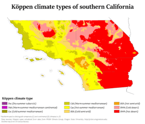
Even though many people think of California as always sunny, the weather here can actually be quite different depending on where you are. But generally, the weather in southern California is mild, especially in winter. It's also quite dry, with some rain near the coast and almost no rain in the desert areas.
Near the coast, the weather doesn't change much. Factors like how far north or south a place is (latitude), the shape of the land (topography), and how close it is to the Pacific Ocean all affect the climate. The big mountain ranges, like the Transverse Ranges and the Peninsular Ranges, play a huge role in shaping the weather.
These mountains basically split southern California into two main climate zones. The busy coastal area west of the mountains has pleasant weather all year. It doesn't get super hot in summer or very cold in winter. But east of the mountains, you'll find the Sonoran Desert and the Mojave Desert. This area is much drier and has more extreme temperatures, meaning very hot summers and colder winters.
Low Clouds and Fog
You'll often hear about low clouds and fog in southern California's weather forecasts. Because of the mountains and the closeness to the Pacific Ocean, this region gets a lot of both.
Fog near the coast often forms when layers of air interact with the cool air from the ocean. This fog can reach up to 20 miles inland, stopping at the mountains. Fog is basically tiny water droplets floating in the air. Southern California's fog can be light, like "ground fog," or very thick, like "Tule fog," especially in winter and spring. This depends on how cold mountain air mixes with warmer ocean air.
However, over the past few decades, coastal clouds have become less common. This is partly due to urban heat (cities getting warmer) and climate change. Scientists have found that the amount of stratus cloud cover has dropped by 25% to 50% since the 1970s.
"May Gray" and "June Gloom"
Unlike the sunny summer, late spring in southern California is often cloudy. Locals call this time "May Gray" and "June Gloom". During this period, the coastal skies can stay cloudy all day. But often, the clouds clear up for some hazy sunshine in the afternoon. The number of gloomy days changes each year. When ocean temperatures are warmer, often due to the El Niño weather pattern, there might be fewer gray days. Cooler ocean temperatures, linked to a La Niña pattern, usually mean more gloomy days.
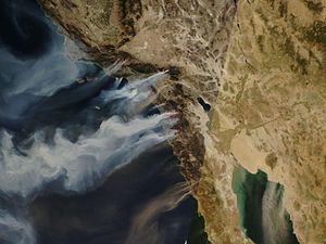
Wildfires
Wildfires are common in southern California because it's often hot, dry, and windy. Most fires are small, but they can quickly grow out of control. This is especially true when strong Santa Ana winds blow. These winds are hot and very dry. They are sometimes called "Devil winds" because they come from the dry interior of the American West. They get even hotter as they move towards the ocean.
Natural wildfires usually happen at the end of long, dry summers. In recent years, they have become a bigger problem because of climate change. Climate change makes wildfires larger and happen more often. It has also made the wildfire "season" last almost all year, instead of just a few summer months. However, scientists also expect climate change to make the Santa Ana winds weaker, which might help limit how much they spread fires.
Physical Geography
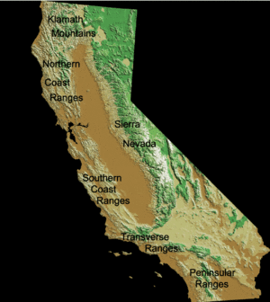
Besides the Pacific Coast, the Transverse Ranges and the Peninsular Ranges are the two most important landforms in southern California. Both mountain ranges have their own special features, like how they are shaped and their different climates.
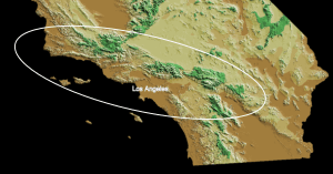
Transverse Ranges
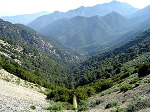
The Transverse Ranges are a special group of mountains in California. They are the only mountain ranges that run from west to east. Most other California ranges run from north to south. These mountains stretch from Santa Barbara County to San Bernardino County. They are called "Transverse" because they cut across the usual north-south direction of California's coastal mountains.
Climate
The Transverse Ranges have noticeable temperature changes between winter and summer. One reason for this is how far they are from the ocean. The eastern part of the Transverse Ranges is furthest from the coast. It has the biggest temperature changes. The western part is closest to the ocean, so its temperatures don't vary as much.
Higher elevations usually mean lower temperatures and more rain or snow. The highest point in these ranges is Mt. San Gorgonio (11,503 feet) in the San Bernardino Mountains. The southeastern part of the Transverse Ranges can be very dry, like a desert. Mountains can create a rain shadow effect. This happens when air from the ocean rises over a mountain, cools, and drops its moisture. By the time it reaches the other side, it's dry and warm. This is why areas furthest from the coast in the Transverse Ranges are so dry. The ranges are also affected by the Santa Ana winds. These dry winds blow from inland towards the ocean, usually starting at the eastern end of the ranges.
Geology
The San Andreas Fault and many other faults run through the Transverse Ranges. Because of this, it's one of the most geologically active areas in California. The ground can shift by small amounts or even several feet. In the western part, you can find Sedimentary rocks from the late Mesozoic era and early Cenozoic era. Near the eastern ranges, like the San Bernardino Mountains, you might find metamorphic rocks that look like those in the Sierra Nevada.
Composite Ranges
These west-to-east running ranges include many different mountains. Some are very steep, like the San Gabriel Mountains. Other parts of the Transverse Ranges are very low, like the Mojave Desert. The mountains that make up the Transverse Ranges include:
- Santa Ynez Mountains
- San Rafael Mountains
- Sierra Madre Mountains
- Topatopa Mountains
- Santa Susana Mountains
- Simi Hills
- Chalk Hills
- Santa Monica Mountains
- San Gabriel Mountains
- San Rafael Hills
- Puente Hills
- San Jose Hills
- San Bernardino Mountains
- Little San Bernardino Mountains
- Tehachapi Mountains
- Sierra Pelona Mountains
- San Emigdio Mountains
Urban Interaction
People have made good use of the Transverse Ranges. The ranges create many coastal plains and valleys. These areas have become very populated because they are great places to live. Examples include the Oxnard Plain, San Fernando Valley, Simi Valley, San Gabriel Valley, and the Inland Valley. The mountains also offer places for fun and living. There are ski resorts and areas for hiking and off-road vehicles. Many people live in the hills of the Transverse Ranges. They might work nearby or travel to busier areas "down the hill." These communities offer a different way of life compared to city living in southern California.
Peninsular Ranges
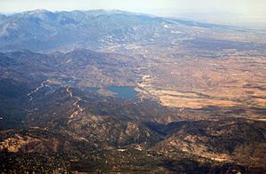
The Peninsular Ranges are a group of mountains that are part of the Pacific Coast Ranges. These ranges stretch over 900 miles from southern California in the United States all the way to the southern tip of Mexico's Baja California peninsula. They are part of the larger North American Coast Ranges that run along the Pacific coast from Alaska to Mexico. The height of these mountains ranges from about 500 feet to 11,500 feet. The plants you see here vary from coastal sage scrub to chaparral, and from oak woodland to conifer forest.
In southern California, the Peninsular Ranges include the Santa Ana Mountains, San Jacinto Mountains, and the Laguna Mountains. These ranges run from north to south.
The Santa Ana Mountains are the largest natural landscape along the southern California coast. Their highest point is Santiago Peak, at about 5,689 feet. This range starts in the north, near Corona, and heads southeast from the Puente Hills area.
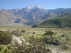
The San Jacinto Mountains are in the desert areas on the north and east side of southern California. They reach about 10,833 feet high. They run from the San Bernardino Mountains southeast to the Santa Rosa Mountains. This mountain range is the northernmost part of the Peninsular Range.
The Santa Rosa Mountains are located at the southern end of the San Jacinto Mountains, where they connect. This range stretches for about 30 miles through Riverside, San Diego, and Imperial counties. They run along the western side of the Coachella Valley, bordering the Anza-Borrego part of the Colorado Desert. The highest peak here is Toro Peak (8,717 feet).
The Laguna Mountains are in the eastern part of San Diego County. They run northwest to southeast for about 20 miles. Their highest point is Cuyapaipe Mountain (6,378 feet). These mountains extend northwest about 35 miles from the Mexican border at the Sierra de Juárez. The Sonora Desert is to the east, and the Santa Rosa Mountains are to the northwest.
Climate
Just like with the Transverse Ranges, areas along the coast in the Peninsular Ranges have less temperature change than inland areas. The Peninsular Ranges also create a rain shadow over the Colorado Desert region of California and much of the larger Sonora Desert. This means they block moisture, making the desert dry. The ranges are also affected by the marine layer, which brings cool temperatures and fog. Rainfall changes with the seasons, especially with tropical storms.
 | May Edward Chinn |
 | Rebecca Cole |
 | Alexa Canady |
 | Dorothy Lavinia Brown |


