
Toro Peak facts for kids
Quick facts for kids Toro Peak |
|
|---|---|

Toro Peak
|
|
| Highest point | |
| Elevation | 8,717 ft (2,657 m) NAVD 88 |
| Prominence | 3,996 ft (1,218 m) |
| Geography | |
| Location | Riverside County, California, U.S. |
| Parent range | Santa Rosa Mountains |
| Topo map | USGS Toro Peak |
Toro Peak is the tallest mountain in the Santa Rosa Mountain Range in Southern California. It stands 8,717 feet (2,657 meters) high.
The mountain is about 15 miles (24 km) south of Palm Springs. It is also 12 miles (19 km) west of the Salton Sea. Toro Peak is located in Riverside County, California.
Different parts of the mountain are managed by different groups.
- Some areas are part of the San Bernardino National Forest.
- The very top, including the summit and a special marker from 1939, is controlled by the Santa Rosa Indian Reservation.
- Other sections are managed by the Santa Rosa and San Jacinto Mountains National Monument.
Contents
Getting to Toro Peak
You can reach Toro Peak from California State Route 74. This road is also called the Pines to Palms Highway. About 5 miles (8 km) east of where Route 74 meets Route 371, there is a dirt road.
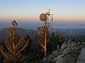
This dirt road starts at 4,700 feet (1,433 meters) high. It goes up for about 13 miles (21 km) towards the mountain's top. The road is steep and rocky, so a strong off-road vehicle is best. The road has a locked gate around 8,200 feet (2,500 meters). From there, it's a 500-foot (152 meter) hike to the summit. This hike is on a rough maintenance road.
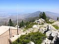
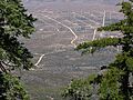
Views from the Summit
From the top of Toro Peak, you can see amazing views. You can look across the Santa Rosa Mountain Range all the way to Palm Springs. You can also spot other tall mountains nearby. These include San Jacinto Peak, Mount San Gorgonio, Palomar Mountain, and Hot Springs Mountain.
If you look to the east and southeast, you will see the Salton Sea and the Imperial Valley. On a clear day, you might even see Charleston Peak in Nevada!
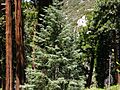
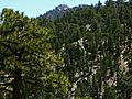
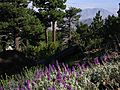
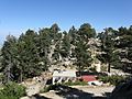
Trees and Plants on Toro Peak

Toro Peak is known as a "sky island" mountain. This means it's a high, cool, and wet area surrounded by much drier, lower land. The mountain has many different types of trees. You can find Incense Cedar, White Fir, Jeffrey Pine, Ponderosa Pine, and Sugar Pine. On the highest slopes, there are even Limber Pine trees. These are very old types of trees from the Ice Age.
What's special about these mountains is how the trees grow. Usually, different types of trees grow at different heights. But here, trees like White Fir and Incense Cedar grow next to trees that like drier weather, such as Jeffrey Pine and Ponderosa Pine. This is because Toro Peak is close to the Pacific Ocean.
Toro Peak's Climate

Winters on Toro Peak can be tough. Snow falls several times during the winter. This snow brings most of the mountain's yearly water. Some rain also comes from summer thunderstorms. The temperatures on Toro Peak are similar to those at the Long Valley Ranger Station on nearby Mount San Jacinto.
Toro Peak is one of many "sky islands" in the southwest. Its high elevation helps to clear the smog from cities like Los Angeles and the Inland Empire. There isn't much human activity on the mountain, just a few remote campsites. The peak has a warm-summer Mediterranean climate (called Csb).
| Climate data for Toro Peak 1981-2010 (33.523 -116.426) | |||||||||||||
|---|---|---|---|---|---|---|---|---|---|---|---|---|---|
| Month | Jan | Feb | Mar | Apr | May | Jun | Jul | Aug | Sep | Oct | Nov | Dec | Year |
| Mean daily maximum °C (°F) | 8.4 (47.1) |
8.6 (47.5) |
10.1 (50.2) |
14.1 (57.4) |
18.6 (65.5) |
23.7 (74.7) |
25.7 (78.3) |
25.4 (77.7) |
22.5 (72.5) |
17.1 (62.8) |
11.9 (53.4) |
8.1 (46.6) |
16.2 (61.1) |
| Daily mean °C (°F) | 3.4 (38.1) |
3.3 (37.9) |
4.4 (39.9) |
7.6 (45.7) |
11.7 (53.1) |
16.6 (61.9) |
19.4 (66.9) |
19.1 (66.4) |
16.3 (61.3) |
11.0 (51.8) |
6.7 (44.1) |
3.0 (37.4) |
10.2 (50.4) |
| Mean daily minimum °C (°F) | −1.6 (29.1) |
−2.1 (28.2) |
−1.3 (29.7) |
1.1 (34.0) |
4.9 (40.8) |
9.5 (49.1) |
13.0 (55.4) |
12.8 (55.0) |
10.0 (50.0) |
4.9 (40.8) |
1.4 (34.5) |
−2.1 (28.2) |
4.2 (39.6) |
| Average precipitation mm (inches) | 120 (4.7) |
102 (4.0) |
60 (2.4) |
20 (0.8) |
11 (0.4) |
1 (0.0) |
26 (1.0) |
37 (1.5) |
19 (0.7) |
19 (0.7) |
41 (1.6) |
103 (4.1) |
559 (21.9) |
| Source: http://www.climatewna.com/ | |||||||||||||
Images for kids
-
Toro Peak from a distance
-
View of the landscape
-
Trees on the mountain
-
Another view of the peak
-
Mountain scenery
-
Path leading up the mountain
-
Rocky terrain
-
Mountain plants


