San Jacinto Peak facts for kids
Quick facts for kids San Jacinto Peak |
|
|---|---|

North face
|
|
| Highest point | |
| Elevation | 10,834 ft (3,302 m) NAVD 88 |
| Prominence | 8,319 ft (2,536 m) ↓ San Gorgonio Pass |
| Isolation | 20.3 mi (32.7 km) → Bighorn Mountain |
| Listing |
|
| Naming | |
| English translation | Saint Hyacinth's Peak |
| Language of name | Spanish |
| Geography | |
| Location | Riverside County, California, U.S. |
| Parent range | San Jacinto Mountains |
| Topo map | USGS San Jacinto Peak |
| Climbing | |
| First ascent | 1874 by "F. of Riverside" |
| Easiest route | Tramway and trail hike |
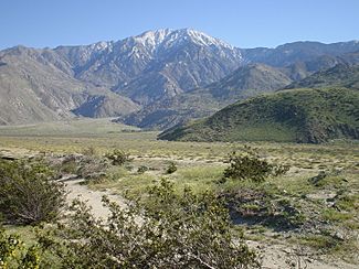
San Jacinto Peak is a huge mountain in Riverside County, California. It is also often called Mount San Jacinto. This peak is about 10,834 feet (3,302 meters) tall. It is the highest point in the San Jacinto Mountains and in Riverside County.
The mountain is part of Mount San Jacinto State Park. It sits at the southern edge of the San Gorgonio Pass. A famous nature writer named John Muir once said that the view from San Jacinto Peak was "the most sublime spectacle to be found anywhere on this earth!"
San Jacinto Peak is one of the most noticeable mountains in the United States. It ranks as the sixth most prominent peak in the 48 connected states. Many hikers in Southern California love to climb "San Jack" at least once.
The mountain is famous for its very steep north side. This side rises over 8,000 feet (2,400 meters) above San Gorgonio Pass. It is also home to the well-known Cactus to Clouds Trail.
Where is San Jacinto Peak?
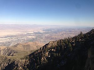
To the east, San Jacinto Peak stands high above the city of Palm Springs. Palm Springs is much lower, at about 479 feet (146 meters) above sea level. To the west, the mountain is next to the town of Idyllwild. Idyllwild is higher up, at about 5,413 feet (1,650 meters).
The north face of the mountain is very steep. It climbs over 10,000 feet (3,000 meters) in just 7 miles (11 kilometers). This is one of the biggest climbs over such a short distance in the contiguous United States.
From the top of San Jacinto Peak, you can see many amazing things. You can see San Gorgonio Mountain across the San Gorgonio Pass. You can also easily spot the Coachella Valley and the Salton Sea below. On a clear day, you might even see parts of the Inland Empire, including Ontario to the west.
Mount San Jacinto is one of the "Four Saints." This name is sometimes used for four mountains in Southern California that are over 10,000 feet tall. They are all named after Catholic saints. The other "Saints" are San Gorgonio Mountain (in the San Bernardino Mountains), San Bernardino Peak, and Mount San Antonio (in the San Gabriel Mountains).
History of San Jacinto Peak
The Cahuilla Native American people call this peak I a kitch or Aya Kaich. This name means "smooth cliffs." They believe it is the home of Dakush, a spirit known as the meteor. Dakush is also a legendary founder of the Cahuilla people.
The first recorded climb of the peak was in September 1874. It was done by someone known only as "F. of Riverside." In 1878, a group of mapmakers, called the Wheeler Survey, climbed the peak. They were led by Charles Thomas. This group gave the mountain the name "San Jacinto Peak."
The very difficult northeast side of the mountain was first successfully climbed in 1931. This climb was made by Floyd Vernoy and Stewart White from Riverside.
Near San Jacinto Peak are two other peaks: Jean Peak and Marion Mountain. These peaks were named in 1897 by a mapmaker named Edmund Taylor Perkins, Jr. He named Jean Peak after his future wife, Jean Waters. He named Marion Mountain after Marion Kelly, who was his girlfriend at the time.
Another nearby peak is called Cornell Peak. It was named after Cornell University. A geologist named Robert T. Hill went to that university. He was camping with Perkins and said the peak looked like a tower at Cornell.
In the early 1930s, there was a footrace from Idyllwild to San Jacinto Peak and back. This race was 18 miles long and involved climbing 5,300 feet. A stone hut was built near the summit in 1935. It was built by the Civilian Conservation Corps.
Hiking San Jacinto Peak
San Jacinto Peak is easy to reach because many trails go through the Santa Rosa and San Jacinto Mountains National Monument. The most popular way to start is by taking the Palm Springs Aerial Tramway. This tram takes you from Valley Station, which is at 2,643 feet (806 meters), up to Mountain Station, at 8,516 feet (2,596 meters). From there, you can hike trails to the top of the mountain.
Another way to hike the mountain is to use the Marion Mountain Trail. This trail starts near the mountain town of Idyllwild.
There are also some giant Sequoiadendron trees growing here. They were planted in 1974 and are reproducing naturally. These trees are usually found hundreds of miles away from this area.
The Cactus to Clouds Trail is a very hard hike. It climbs about 10,700 feet (3,260 meters) from the desert floor in Palm Springs to the summit. This trail has no water sources until you reach about 8,500 feet (2,600 meters). It is best to start this hike very early in the morning. This helps you avoid the hot temperatures, which can often go above 100°F (38°C).
 | Roy Wilkins |
 | John Lewis |
 | Linda Carol Brown |


