
Mount San Antonio facts for kids
Quick facts for kids Mount San Antonio |
|
|---|---|
| Mount Baldy | |
,_California.jpg)
South face of Mt. San Antonio, seen above Upland, California
|
|
| Highest point | |
| Elevation | 10,064 ft (3,068 m) The National Map of the United States |
| Prominence | 6,224 ft (1,897 m) ↓ Cajon Pass |
| Isolation | 42.52 mi (68.43 km) → San Bernardino Peak |
| Listing |
|
| Naming | |
| Etymology | Saint Anthony of Padua |
| Native name | Error {{native name}}: an IETF language tag as parameter {{{1}}} is required (help) |
| Geography | |

Mount San Antonio
Location in California

Mount San Antonio
Location in the United States
|
|
| Location | Los Angeles / San Bernardino counties, California U.S. |
| Parent range | San Gabriel Mountains |
| Topo map | USGS Mount San Antonio |
| Geology | |
| Mountain type | Granitic |
| Climbing | |
| Easiest route | Ski lift to Baldy Notch, Devil's Backbone Trail (hike) |

Mount San Antonio, often called Mount Baldy or Old Baldy, is a tall mountain in California. It stands 10,064 ft (3,068 m) high in the San Gabriel Mountains. This mountain sits on the edge of Los Angeles and San Bernardino counties.
Mount Baldy is the highest point in the San Gabriel Mountains. It is also the tallest peak in Los Angeles County and the wider Los Angeles area. On clear days, you can see its snowy top from far away, even from the Los Angeles Basin. Hikers can reach the summit using trails from all sides of the mountain.
Contents
What's in a Name?
The Tongva are Native Americans who lived in this area. They called the mountain Yoát or Joat, which means snow. The Mohave called it Avii Kwatiinyam.
The name Mount San Antonio likely came from Antonio Maria Lugo. He owned a large ranch around 1840. He named the mountain after his favorite saint, Anthony of Padua.
Most local people call the mountain "Mount Baldy." Many might not even know its official name. Early American settlers saw the mountain's bare, treeless south face. They called it "Baldy" because it looked bald. This name has been used ever since. However, some places, like Mount San Antonio College, still use the original name.
Mountain Geography

Mount San Antonio is located within the Angeles National Forest. Its highest point is 10,064 feet (3,068 m) above sea level. This peak marks the border between San Bernardino County and Los Angeles County. A slightly lower peak nearby, called West Baldy, is 10,002 feet (3,049 m) tall.

Water from the south side of the mountain flows into San Antonio Creek. Water from the north side goes into Lytle Creek and the Fish Fork of the San Gabriel River. These creeks eventually join the Santa Ana River. San Antonio Creek flows through a deep canyon with several waterfalls. One waterfall is about 75 feet (23 m) high.
East of the main summit is Mount Harwood. A narrow path called "The Devil's Backbone" connects it to a spot called Baldy Notch. At Baldy Notch, you'll find a ski resort. It is the closest ski resort to Los Angeles. South of the resort is Mt Baldy Village.
There are no main roads or trails connecting the mountain to the less populated areas north of it. However, a path goes over Dawson Peak and Pine Mountain. It leads to Wright Mountain and the Pacific Crest Trail, which overlooks Wrightwood.
Mountain Weather
A weather station in the 1960s, located at about 7,700 feet, recorded a lot of snow. On average, it snowed 131 inches each year. The most snow often falls late in the season. For example, in April 1967, 120 inches of snow fell.
Nature on the Mountain

How the Mountain Formed
Mount San Antonio is part of the San Gabriel Mountains. These mountains are one of the Transverse Ranges in Southern California. They formed because of the San Andreas Fault system. This fault is where two large pieces of the Earth's crust, called plates, slide past each other. A bend in the fault makes it hard for the plates to move smoothly. This pushing and grinding created the mountains.
Long ago, a huge landslide called the Hog Back landslide happened in San Antonio Creek canyon. It blocked the river, creating a deep lake. When the water finally broke through, it carved a narrow canyon. Today, this canyon has some challenging rock climbing routes.
In more recent times, big floods happened in 1938 and 1969. The San Antonio Dam was built in 1956. Its purpose was to stop floods like the one in 1938, which caused a lot of damage. The dam helped a lot during the 1969 flood. Hydroelectric plants along San Antonio Creek also generate electricity.
Plants and Trees

The lower parts of the mountain have a yellow pine forest. Here you can find lodgepole pine, Jeffrey pine, white fir, and some sugar pine trees. These forests are not very dense. They are mixed with chaparral shrubs and oak trees.
Higher up, the yellow pine forest changes to mostly lodgepole pines. Around 9,000 feet (2,750 m), these trees become twisted and stunted by the wind and cold. Above 9,500 feet (2,900 m), there are no trees at all. This area is called the alpine zone. Mountain mahogany trees grow on the slopes above San Antonio Creek.
Common shrubs at higher elevations include manzanita and bush chinquapin. Other shrubs are mountain whitethorn, buckwheat, and mountain gooseberry.
Many wildflowers also grow here. Some examples are Galium parishii, San Gabriel alumroot, and pumice alpinegold.
Animals of Mount Baldy
Desert bighorn sheep live in the area, mostly above 7,000 feet. They have strong, curved horns and are good at climbing rocky slopes. Their population in the San Gabriel Mountains is doing well.
.jpg)
Grizzly bears used to live in these mountains. They are even on California's state flag. However, they disappeared from California in the late 1800s. The last grizzly in the San Gabriels was seen in 1894. Black bears were not originally from the San Gabriel Mountains. In 1933, eleven black bears from Yosemite Valley were moved here. All black bears in the San Gabriels today are thought to be descendants of this group. Black bears are usually shy and rarely bother people.
You can find rabbits and coyotes near San Antonio Creek at lower elevations. The most common rabbits are the black-tailed jackrabbit and the desert cottontail. Jackrabbits are easy to spot with their huge ears. Western gray squirrels live in oak forests at lower elevations. Merriam's chipmunk lives in areas with manzanita shrubs.
At higher elevations, you might see lodgepole chipmunks and California ground squirrels. These rodents hibernate during winter. Rabbits can also sometimes be seen at high elevations.
Fun Things to Do
Hiking Trails
Hiking trails lead to the summit from all four sides of the mountain. You can also take Chair #1 at Mount Baldy Resorts to Baldy Notch. From there, you can access the Devil's Backbone trail.
The trails offer different levels of difficulty. There are options for both new hikers and experienced adventurers.
- Mt. Baldy Notch – (3.5 miles one way): This trail starts at Manker Flats. You can walk the Baldy Notch Service Road to the notch. It offers great views and connects to other trails.
- Devil's Backbone – (3.2 miles one way from Notch): A service road at Mt. Baldy Notch leads to this trail. It continues all the way to the main peak.
- Mt. Baldy Trail – (6.5 miles one way to Mt. Baldy Summit): This is the oldest and longest trail to the top. It starts in Mt. Baldy Village. Hikers gain almost 6,000 feet in elevation.

- Icehouse Canyon – (3.7 miles one way): This trail begins at the Icehouse parking lot. It goes up to Icehouse Saddle. From there, you can take other trails to the Notch or to nearby peaks.
- Ski Hut Trail – This trail follows the east side of San Antonio Creek canyon. It leads to a small ski hut owned by the Sierra Club. A path continues from the hut to the summit.
Winter Adventures
In winter, Mount Baldy is usually covered in snow. This makes it a great place for snow climbing. The "Baldy Bowl" south of the summit is a popular spot for climbers. They often use crampons (spikes for boots) and an ice ax. Some parts of the bowl are very steep, so it can be dangerous for new climbers. Avalanches and falling rocks are risks here.
The Sierra Club Hut

The Sierra Club Angeles Chapter runs a ski hut. It is open on weekends all year round. The hut is about halfway up the Ski Hut Trail, at 8,200 feet. It has a kitchen, water, solar lights, and beds for about sixteen people. The hut was built by volunteers in 1936. They carried all the building materials up the mountain on their backs. The original hut burned down but was quickly rebuilt.
Camping Fun

Manker Flats Campground is open to the public. It works on a first-come, first-served basis. It is located 3 miles northeast of Mt. Baldy Village. The campground has 21 campsites with stoves, water, toilets, and tables. There are no showers. Camping costs $12 per night.
Cycling Challenges
For road cyclists, the climb through Mt. Baldy Village to the ski lifts is very popular. It has been a challenging finish line for stages of the Tour of California bike race several times.
Running Races
Since 1965, a "Run to the Top" race has been held on Labor Day. It's an 8-mile (13 km) course that goes up about 4,000-foot (1,200 m) in elevation. The race finishes at the main peak.
Hunting
Hunting is allowed in the area. However, you need a license and must follow specific rules.
A Look at History
Early Uses of the Mountain
The first developments in the Mount Baldy area happened around the time of the United States Civil War. People came to use the mountain's resources. Some of the first permanent residents were Mormon settlers in Lytle Creek Canyon in 1851.
In 1859, Victor Beaudry and Damien Marchessault built an icehouse in Icehouse Canyon. This canyon kept snow late into spring. They brought ice down from the mountains by mule and wagon. The ice was sold in Los Angeles, even at their ice cream shop.
Gold mining started later in the area, around the 1870s. Miners used different methods to find gold. The Banks (Hocumac) Mine was built in 1893 near Baldy Notch. Another mine, the Gold Ridge Diggings, was near San Antonio Canyon. These mines were not very successful.
The Resort Era

By the late 1800s, people became more interested in Mount Baldy for fun and relaxation. In 1875, an army group made the first recorded climb to the summit. Resorts and camps began to appear. Frank Keyes turned Dell's Camp, which used to support miners, into a place for visitors. Early mountain guide William B. Dewey led groups to the summit.
In 1910, Dewey built the Baldy Summit Inn near the mountaintop. It was just tents and storage buildings. It was damaged by fire in 1913 and never rebuilt. By the early 1920s, there were many camps and resorts.
The San Antonio Water Company owned the water rights in the canyon. They had conflicts with the camp owners over pollution. Eventually, the company decided to make money from recreation. They bought Baynham's Camp in 1907 and renamed it Camp Baldy in 1910.
When the area became a national forest in 1908, the forest service offered leases for vacation cabins. Many cabins were built in Icehouse Canyon and other areas.
Between 1922 and 1927, scientist Albert A. Michelson did experiments here. He bounced a beam of light off a reflector on Lookout Mountain to measure the speed of light.
Prohibition and the Great Depression
During Prohibition, when alcohol was illegal, the area became a secret getaway. People could find drinks away from the police. Camp Baldy became a fun place for wealthy people from Los Angeles. It had a swimming pool, casino, and dance hall.
From 1935 to 1936, the Civilian Conservation Corps built a wider trail along the Devil's Backbone. This path made the route to the summit much safer.
Aurelia Harwood, the first female president of the Sierra Club, was very active here. A peak, Mount Harwood, is named after her. The Sierra Club also built a lodge and the "ski hut" in the area.
After the 1938 Flood
The great flood of 1938 destroyed most of the buildings in Camp Baldy and Icehouse Canyon. The casino was lost, but the hotel (now Buckhorn Lodge) survived. After the flood, no new building was allowed in Icehouse Canyon. Camp Baldy was rebuilt and is now Mt. Baldy Village.
On March 2, 1949, two Marine Corps fighter planes crashed into the mountain during a snowstorm. Pieces of the wreckage are still scattered on the slope.

The ski lift was first built in 1952 and updated in 1975. Today, Mt. Baldy Village has its own fire department, church, visitor center, and school district. The visitor center is run by volunteers.
In January 2023, the actor Julian Sands, who loved mountaineering, went missing while hiking on Mount San Antonio. His remains were found by hikers in June 2023.
Images for kids
-
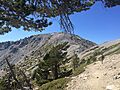
Looking northwest at Baldy Summit from Devil's Backbone near Mt. Harwood
-
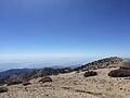
Looking southwest from Mt. Baldy Summit
-
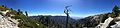
Panorama looking south toward Los Angeles just below the summit


See also
 In Spanish: Monte San Antonio para niños
- List of highest points in California by county
- List of Ultras of the United States
- Mount Baldy Ski Lifts
- Mt. Baldy Joint School District
- Mt. San Antonio College
- San Gabriel Mountains National Monument
