
Compton, California facts for kids
Quick facts for kids
Compton
|
||
|---|---|---|
  .jpg) Top: Martin Luther King, Jr. Memorial (left) and Compton High School (right); bottom: Dominguez Rancho Adobe.
|
||
|
||
| Nickname(s):
Hub City
|
||
| Motto(s):
Birthing a New Compton
|
||

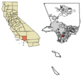
Location within Los Angeles County, California
|
||

Compton
Location in the Los Angeles metropolitan area

Compton
Location in California

Compton
Location in the United States
|
||
| Country | ||
| State | ||
| County | Los Angeles | |
| Incorporated | May 11, 1888 | |
| Named for | Griffith Dickenson Compton | |
| Government | ||
| • Type | Council-Manager | |
| Area | ||
| • Total | 10.12 sq mi (26.20 km2) | |
| • Land | 10.03 sq mi (25.97 km2) | |
| • Water | 0.09 sq mi (0.23 km2) 1.03% | |
| Elevation | 69 ft (21 m) | |
| Population
(2020)
|
||
| • Total | 95,740 | |
| • Rank | 87th in California | |
| • Density | 9,548.22/sq mi (3,686.42/km2) | |
| Time zone | UTC−8 (Pacific) | |
| • Summer (DST) | UTC−7 (PDT) | |
| ZIP codes |
90220–90224
|
|
| Area codes | 310/424 | |
| FIPS code | 06-15044 | |
| GNIS feature IDs | 1652689, 2410213 | |

Compton is a city in southern Los Angeles County, California, in the United States. It's located just south of downtown Los Angeles. Compton is one of the oldest cities in the county. It became an official city on May 11, 1888.
In 2020, about 95,740 people lived there. Compton is often called the "Hub City" because it's right in the middle of Los Angeles County. Some of its neighborhoods include Sunny Cove, Leland, downtown Compton, and Richland Farms.
Contents
History of Compton


Long ago, the Tongva people lived in the Los Angeles area. Later, the Spanish Empire explored this land in the 1500s. In 1784, the Spanish King gave a large piece of land, called Rancho San Pedro, to a soldier named Juan José Domínguez. This huge ranch was over 75,000 acres.
The Domínguez family later divided and sold parts of this land. The family name is still used in the area, like the Dominguez Rancho Adobe historical landmark. A special tree that marked the ranch's original northern border still stands today.
In 1867, a group of 30 pioneers, led by Griffith Dickenson Compton, came to the area. They had traveled from Stockton, California, looking for new ways to live after the gold rush. At first, the settlement was called Gibsonville, then Comptonville. To avoid confusion with another town, the name was shortened to Compton.
The early settlers faced many challenges, like harsh weather and finding fuel. They had to travel far to get firewood. Even with difficulties, they decided to stay because there were two general stores nearby.
By 1887, the settlers wanted to improve their local government. They held meetings to make their town an official city. Griffith D. Compton gave his land to help create the city of Compton in 1889. He made sure some land was kept for farming, calling it Richland Farms. On May 11, 1888, Compton officially became a city with about 5,000 people.
In 1890, the city became much smaller due to some votes. It was only eighty acres with five voters. This made it hard for Compton to work as a city. But by 1906, lawyers helped bring Compton back to its original size of 600 acres. New elections were held, and Compton was "reborn."
The large lots in Richland Farms were perfect for families to grow food and raise animals. This attracted many Black families moving from the South in the 1950s. They found a welcoming place in Compton.
The 1920s brought new things to Compton, like the Compton Airport and Compton Junior College. A new City Hall was also built. In 1933, a strong earthquake caused a lot of damage and injuries.
From the 1920s to the early 1940s, many Japanese American families lived in Compton, often as farmers. During World War II, in 1942, these families were forced to leave their homes. They were sent to special camps, called "internment centers," for the rest of the war.
In the 1950s, more middle-class Black families started moving to Compton. The city grew quickly. This was partly because it was close to Watts, which already had a large Black community. The eastern part of Compton was mostly white until the 1970s. Even today, a small area of farmland remains from Compton's early days.
During the 1950s and 1960s, laws that prevented people of different races from living in certain areas were ended. This allowed the first Black families to move into Compton. The city's Black population grew, and new schools like Centennial High School were built. In 1961, the first Black councilman was elected to the city government.

In 1969, Douglas Dollarhide became the first Black mayor of a major city in California. Later, in 1973, Doris A. Davis became the first Black female mayor of a major American city. By the early 1970s, a large part of Compton's population was African American. In 2013, Aja Brown, at 31, became the city's youngest mayor. She was re-elected in 2017.
For many years, Compton was a popular place for middle-class Black families in Los Angeles. The city has many spacious and attractive single-family houses. However, some things caused Compton to change over time. One reason was that the city had less money from taxes. Also, some white middle-class families moved to newer cities nearby in the late 1950s. This movement of people continued after major events in 1965 and 1992.
By the late 1960s, some middle-class African Americans found other areas more appealing. These included places like Ladera Heights and Inglewood. The city of Carson, which became its own city in 1968, was also popular. Carson offered lower taxes and less crime, attracting many families.
Geography and Climate

.gif)
Compton covers about 10.1 square miles (26.2 square kilometers). Most of this area is land, with a small part being water.
Compton is surrounded by several other communities and cities. To the north and northwest is Willowbrook. West Compton is to the west, and Carson is to the southwest. Rancho Dominguez is to the south, and Long Beach is to the southeast. Paramount and East Compton are to the east, and Lynwood is to the northeast.
East Compton
East Compton, also known as East Rancho Dominguez, is a community that is mostly industrial. It's not an official city but a "census-designated place." In 2010, about 15,135 people lived there. East Rancho Dominguez shares a ZIP Code with Compton. The city of Compton has tried to make East Rancho Dominguez part of Compton, but businesses and property owners there have not agreed.
Climate
| Climate data for Compton, California | |||||||||||||
|---|---|---|---|---|---|---|---|---|---|---|---|---|---|
| Month | Jan | Feb | Mar | Apr | May | Jun | Jul | Aug | Sep | Oct | Nov | Dec | Year |
| Record high °F (°C) | 93 (34) |
91 (33) |
98 (37) |
105 (41) |
104 (40) |
108 (42) |
109 (43) |
105 (41) |
111 (44) |
111 (44) |
101 (38) |
91 (33) |
111 (44) |
| Mean daily maximum °F (°C) | 67 (19) |
68 (20) |
68 (20) |
72 (22) |
73 (23) |
77 (25) |
81 (27) |
82 (28) |
81 (27) |
77 (25) |
72 (22) |
68 (20) |
74 (23) |
| Mean daily minimum °F (°C) | 46 (8) |
48 (9) |
50 (10) |
53 (12) |
57 (14) |
60 (16) |
63 (17) |
64 (18) |
63 (17) |
58 (14) |
51 (11) |
46 (8) |
55 (13) |
| Record low °F (°C) | 25 (−4) |
33 (1) |
33 (1) |
38 (3) |
40 (4) |
46 (8) |
51 (11) |
54 (12) |
50 (10) |
39 (4) |
34 (1) |
28 (−2) |
25 (−4) |
| Average precipitation inches (mm) | 3.21 (82) |
3.32 (84) |
2.68 (68) |
0.68 (17) |
0.24 (6.1) |
0.08 (2.0) |
0.02 (0.51) |
0.12 (3.0) |
0.25 (6.4) |
0.40 (10) |
1.15 (29) |
1.81 (46) |
13.96 (355) |
People of Compton
| Historical population | |||
|---|---|---|---|
| Census | Pop. | %± | |
| 1870 | 160 | — | |
| 1890 | 636 | — | |
| 1910 | 922 | — | |
| 1920 | 1,478 | 60.3% | |
| 1930 | 12,516 | 746.8% | |
| 1940 | 16,198 | 29.4% | |
| 1950 | 47,991 | 196.3% | |
| 1960 | 71,812 | 49.6% | |
| 1970 | 78,547 | 9.4% | |
| 1980 | 81,350 | 3.6% | |
| 1990 | 90,454 | 11.2% | |
| 2000 | 93,493 | 3.4% | |
| 2010 | 96,455 | 3.2% | |
| 2020 | 95,740 | −0.7% | |
| U.S. Decennial Census 1850–1870 1880-1890 1900 1910 1920 1930 1940 1950 1960 1970 1980 1990 2000 2010 2020 |
|||
Compton was first counted as a city in the 1870 U.S. Census.
Compton Today: 2020 Census
The U.S. Census Bureau reported that Compton had about 91,988 people in 2022. Here's what we know about homes and families from 2018 to 2022:
- More than half of homes (57.4%) are owned by the people living in them.
- The average value of these homes was $489,400.
- There were about 24,617 households, with an average of 3.83 people per home.
- The average household income was $69,728.
Most residents in Compton are U.S. citizens (83.1%).
| Race / Ethnicity (NH = Non-Hispanic) | Pop 1980 | Pop 1990 | Pop 2000 | Pop 2010 | Pop 2020 | % 1980 | % 1990 | % 2000 | % 2010 | % 2020 |
|---|---|---|---|---|---|---|---|---|---|---|
| White (NH) | 2,191 | 1,321 | 954 | 782 | 856 | 2.69% | 1.46% | 1.02% | 0.81% | 0.89% |
| Black or African American (NH) | 60,096 | 47,680 | 37,263 | 30,992 | 24,342 | 73.87% | 52.71% | 39.86% | 32.13% | 25.43% |
| Native American or Alaska Native (NH) | 162 | 116 | 170 | 175 | 132 | 0.2% | 0.13% | 0.18% | 0.18% | 0.14% |
| Asian (NH) | 1,382 | 1,525 | 189 | 222 | 365 | 1.7% | 1.69% | 0.2% | 0.23% | 0.38% |
| Native Hawaiian or Pacific Islander alone (NH) | – | – | 953 | 684 | 544 | – | – | 1.02% | 0.71% | 0.57% |
| Other race alone (NH) | 293 | 302 | 100 | 140 | 440 | 0.36% | 0.33% | 0.11% | 0.15% | 0.46% |
| Mixed race or Multiracial (NH) | – | – | 721 | 791 | 1,270 | – | – | 0.77% | 0.82% | 1.33% |
| Hispanic or Latino (any race) | 17,162 | 39,510 | 53,143 | 62,669 | 67,791 | 21.1% | 43.68% | 56.84% | 64.97% | 70.81% |
| Total | 81,350 | 90,454 | 93,493 | 96,455 | 95,740 | 100.00% | 100.00% | 100.00% | 100.00% | 100.00% |
2010 Census Data
In 2010, Compton had a population of 96,455 people. The population density was about 9,534 people per square mile. The city was made up of different groups:
- 32.9% Black
- 25.9% White (0.8% Non-Hispanic White)
- 0.7% Native American
- 0.3% Asian
- 0.7% Pacific Islander
- 36.2% from other races
- 3.4% from two or more races.
- 65.0% of the people were Hispanic or Latino.
Most people (99.2%) lived in homes. There were 23,062 households. About 58% of these homes had children under 18. The average household had 4.15 people.
The population's age breakdown was:
- 33.1% were under 18.
- 12.3% were 18 to 24.
- 27.5% were 25 to 44.
- 19.5% were 45 to 64.
- 7.5% were 65 or older.
The average age was 28.0 years.
In 2009–2013, the average household income in Compton was $42,953.
Compton's Economy

In 1994, Compton was named an "Entrepreneurial Hot Spot." This means it was a great place to start and grow a business. It ranked second among 88 cities in Los Angeles County for business growth. The city helps small business owners with many resources.
Some large grocery companies, like Ralphs and Food 4 Less, have their main offices in Compton. Gelson's Market is also based there.
Compton has many freeways nearby, making it easy to travel around the region. The Port of Long Beach and Port of Los Angeles are less than 20 minutes away. These ports are important for international trade. The Alameda Corridor, a special route for a lot of U.S. international trade, goes right through Compton.
The city's Parks and Recreation Department takes care of 16 playgrounds and 118 acres of park space. They have six community centers, seven neighborhood parks, and two swimming pools. There are also three gyms, a skate park, Jackie Robinson Baseball Stadium, and a golf course. The Douglas F. Dollarhide Community Center is a large two-story building.
Arts and Culture in Compton
Compton has been featured in popular culture. Some episodes of the TV show The Fresh Prince of Bel-Air took place in Compton.
Many famous rap artists started their careers in Compton. These include N.W.A (with members like Eazy-E, Dr. Dre, and Ice Cube), Coolio, The Game, and Kendrick Lamar. Their songs often talk about life in Compton. Blues musician Keb' Mo' and artist Steve Lacy are also from Compton.
Compton is well-known for its connection to hip hop music. The city honored rapper Eazy-E (Eric Lynn Wright) by renaming a street "Eazy Street" in 2023. Eazy-E was part of the group N.W.A, which released the famous song "Straight Outta Compton" in 1988.
Many NBA basketball players went to high school in Compton. These include Arron Afflalo, DeMar DeRozan, Tayshaun Prince, and Tyson Chandler. Actor and comedian Paul Rodriguez Sr. also attended high school there.
In recent years, more middle-class people have moved to Compton because homes are affordable. The city's population has become younger, with the average age being 25 in 2010.
Compton is home to the Compton Cricket Club. This is the only cricket team in the U.S. made up of all American-born players. The club's founder, Ted Hayes, said they play cricket to teach respect. Tam's Burgers is also a well-known symbol of the city.
Historical Landmarks
- Angeles Abbey Memorial Park has beautiful buildings in Byzantine, Moorish, and Spanish styles. It was built in 1923 and survived the 1933 earthquake.
- Compton/Woodley Airport opened in 1924. It offers flight training and holds over 200 planes.
- The Martin Luther King, Jr. Memorial is in a plaza surrounded by important city buildings.
- The Eagle Tree was a natural marker for the old Rancho San Pedro ranch, dating back to 1858. It had a historical marker from 1947. The tree fell in 2022.
- The 'Heritage House' was built in 1869. It is the oldest house in Compton and a California Historical Landmark. It shows how simple life was in the 1800s compared to today.
- Woodlawn Memorial Park is a cemetery where 17 American Civil War veterans are buried.
Education in Compton

The Compton Unified School District (CUSD) serves most of the city. CUSD works with the University of California, Irvine on a program called FOCUS. This program helps improve math and science learning for students.
The CUSD provides public education from kindergarten to 12th grade. It has 24 elementary schools, eight middle schools, and three high schools. There is also an adult school and five alternative learning schools.
The main high schools in CUSD are Centennial High School, Compton Early College High School, Dominguez High School, and Compton High School.
Compton also has Compton College. This college offers courses for students who want to go to a four-year university. It also has programs for specific job skills.
The Compton Library has books and materials for adults, children, and Spanish speakers. It offers help with homework and has computers with internet access. They also have a bilingual story time every Saturday.
The Barack Obama Charter School is a public school for students from kindergarten through sixth grade.
City Services and Transportation
The Los Angeles County Department of Health Services has a health center in Watts that serves Compton residents. The United States Postal Service has several post offices in Compton.
Law Enforcement
The Los Angeles County Sheriff's Department (LASD) handles law enforcement in Compton. They took over from the Compton Police Department in 2000. The Compton Station is easy to reach from several major freeways.
Transportation in Compton


Four major freeways are in or near Compton, making it easy to get around. These include Interstate 710, State Route 91, Interstate 105, and Interstate 110.
The Metro A Line (formerly the Blue Line) is a light rail train that runs through Compton. The Compton station is in the city center. The Artesia station serves the southern part of the city. This train connects Compton to downtown Los Angeles and downtown Long Beach.
Compton also has its own local bus system, the Compton Renaissance Transit System.
Compton/Woodley Airport is a small airport in the city. It's used for general aviation, like flight training. The airport is close to both Los Angeles International Airport and Long Beach Airport.
Greyhound Lines also has a bus station in Compton. All these transportation options help explain why Compton is called "the Hub City."
From 1902 to 1961, Compton was also served by the Pacific Electric Long Beach Line, an old train system.
Famous People from Compton
Sister Cities
Compton has a "sister cities" program to build friendships with cities around the world. Since 2010, Compton has partnered with:
 Apia, Samoa
 Onitsha, Nigeria
 Torrejon de Ardoz, Spain
Images for kids
-
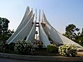
The Martin Luther King, Jr. Memorial in Compton.
-
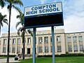
Compton High School.
-
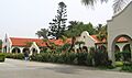
The Dominguez Rancho Adobe Museum.
-
The official seal of Compton, California.
-
Map showing Compton's location in Los Angeles County.
See also
 In Spanish: Compton para niños
