Los Angeles flood of 1938 facts for kids

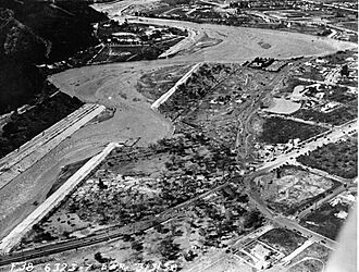
The Los Angeles River overflowing its banks near Griffith Park
|
|
| Date | February–March 1938 |
|---|---|
| Location | Los Angeles, Orange, Riverside, San Bernardino and Ventura counties, California |
| Deaths | 113-115 |
| Property damage | About US$78 million ($1.62 billion in 2022 dollars) 5,601 buildings destroyed 1,500 buildings damaged several small towns completely destroyed Large portions of Riverside and Orange counties completely inundated |
The Los Angeles Flood of 1938 was a huge flood in southern California. It hit Los Angeles, Orange, and Riverside Counties very hard. Two big storms from the Pacific Ocean caused it. They brought almost a year's worth of rain in just a few days during February and March 1938. Sadly, between 113 and 115 people lost their lives.
The Los Angeles, San Gabriel, and Santa Ana Rivers overflowed. This flooded many areas like the coastal plain, the San Fernando and San Gabriel Valleys, and the Inland Empire. Some flood control structures helped protect parts of Los Angeles County. However, Orange and Riverside Counties saw much more damage.
This flood is known as a "50-year flood," meaning it's a very rare event. It caused about $78 million in damage. This made it one of the most expensive natural disasters in Los Angeles' history. After the flood, the U.S. Army Corps of Engineers started building concrete channels for rivers. They also built many new dams and debris basins. These projects have helped protect Southern California from big floods since then, like those in 1969 and 2005.
Contents
Why Did the Flood Happen?
The Los Angeles area is located between the Pacific Ocean and the tall San Gabriel Mountains. This means it often gets sudden floods. These floods happen when heavy rain from Pacific storms hits the mountains. The ground in this dry area is too hard to soak up water quickly during storms. This causes a lot of water to run off the surface. The steep, rocky mountains also make the water run off even faster, leading to dangerous floods.
Between February 27 and 28, 1938, a storm moved from the Pacific Ocean into the Los Angeles area. It then moved east into the San Gabriel Mountains. The area received about 4.4 inches (110 mm) of rain almost non-stop. This caused small floods that affected a few buildings and low areas near rivers.
Fifteen hours later, on March 1, a second, stronger storm hit. It brought very strong winds along the coast and even more rain. This storm brought the total rainfall to 10 inches (250 mm) in low areas. In the mountains, it rained up to 32 inches (810 mm). When the storm finally ended on March 3, the damage was terrible.
What Were the Effects of the Flood?
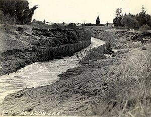
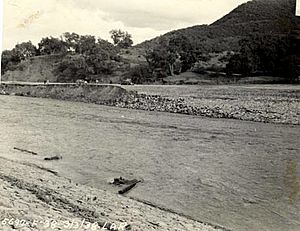
The 1938 flood destroyed 5,601 homes and businesses. Another 1,500 properties were damaged. The flood also brought huge amounts of mud, rocks, and fallen trees from the mountains. These mudslides rushed out of the canyons. Roads and railroads were buried, and power, gas, and phone lines were cut. This stopped transportation and communication for many days.
Dozens of bridges were destroyed by the powerful floodwaters. Some were hit by floating buildings and other debris. Some towns were buried under 6 feet (1.8 m) of sand and mud. This required a massive cleanup effort afterward. It took days or even a week to reopen highways in most affected areas. The Pacific Electric train system, which served many counties, was shut down for three weeks.
Even though the 1938 flood caused the most damage in Los Angeles' history, the amount of rain and river peaks were not as high as the Great Flood of 1862. However, in 1862, the region had far fewer people living there than in 1938.
Impact in Los Angeles Area

About 108,000 acres (44,000 ha) were flooded in Los Angeles County. The San Fernando Valley was hit the hardest. Many communities had been built there in the 1920s in low areas that used to be farmland. In fact, many homes were in old riverbeds that hadn't flooded in years.
The Los Angeles River swelled with water from its flooded smaller rivers. It reached a huge flow of about 99,000 cubic feet per second (2,800 m³/s). The water rushed south, flooding Compton before reaching Long Beach. There, a bridge at the river's mouth collapsed, killing ten people. To the west, Venice and other coastal towns were flooded by water from Ballona Creek.
A reporter flying over the area described the disaster. He saw "gutted farmlands, ruined roads, shattered communications, wrecked railroad lines." Communities and mining areas in the San Gabriel Mountains, like Camp Baldy, were destroyed. Hundreds of people were stranded for days. About 25 buildings were destroyed in the Arroyo Seco canyon. Luckily, everyone was safely evacuated.
Almost every road and trail in the Angeles National Forest was damaged or destroyed by erosion and landslides. About 190 men from a Civilian Conservation Corps camp had to be rescued using a cable across Big Tujunga Canyon.
The Tujunga Wash reached its highest flow on March 3. The water flow was estimated at 54,000 cubic feet per second (1,500 m³/s). The upper Big Tujunga Canyon was almost completely cleared of buildings not high above the flood line. In the San Fernando Valley, floodwaters spread widely after escaping the normal channels of Tujunga Creek. The waters reached deep into the valley, flooding Van Nuys. Five people died when the Lankershim Boulevard bridge collapsed near Universal City. The flooding would have been much worse if a large mudslide had not been stopped by Big Tujunga Dam.
Impact in San Gabriel Valley
On the San Gabriel River, dams built before 1938 greatly reduced the flood's impact. Upstream, Cogswell Dam, finished in 1934, helped reduce the flood on the West Fork. Further downstream, the still-unfinished San Gabriel Dam filled up and overflowed. However, it held back a lot of water. The maximum water released from San Gabriel Dam was controlled. The Morris Dam further reduced the water flow.
Because of these dams, much of the San Gabriel Valley was saved from severe flooding. Still, some areas had heavy damage. In Azusa, four parts of the 1907 "Great Bridge" were swept away. This bridge had survived floods for over 30 years.
Along the East Fork of the San Gabriel River, much of a new highway was destroyed. This highway was meant to connect the San Gabriel Valley to Wrightwood. Today, only the southern part of the highway has been rebuilt as East Fork Road. North of Heaton Flat, little remains except for the Bridge to Nowhere. This 120-foot (37 m) tall arch bridge was saved because it was so high above the floodwaters. It's now a popular spot for hikers and bungee jumpers.
Impact in Riverside and Orange Counties
In Riverside and Orange Counties, the Santa Ana River reached a peak flow of about 100,000 cubic feet per second (2,800 m³/s). This completely overwhelmed the surrounding walls and turned low-lying areas into huge, shallow lakes. A reporter called the river "swollen crazy-mad." Forty-three people died in Atwood and La Jolla in Placentia. Flooding in the city of Riverside took another 15 lives. The cities of Anaheim and Santa Ana in Orange County were flooded up to 6 feet (1.8 m) deep for several weeks.
Impact in the High Desert
Most of the damage happened on the southwestern side of the San Gabriel and San Bernardino Mountains. However, a lot of rain also fell on the northeast side, which drains into the Mojave Desert. The Little Rock Dam on Little Rock Creek overflowed. This happened because a damaged drain was blocked by debris. Hundreds of people in Palmdale had to be evacuated.
Further east, the Mojave River overflowed. It damaged long parts of the ATSF railroad. It also caused damage in Victorville and Barstow. The main train line between Barstow and Los Angeles was closed for a week. The Southern Pacific Railroad line over Tehachapi Pass was closed for two weeks. This meant emergency travel had to be done by buses and trucks.
What Happened After the Flood?
Dams like those at San Gabriel and Big Tujunga greatly reduced damage in the 1938 flood. Many even larger dams were built after the flood to better protect communities. Hansen Dam was being built but was not finished during the 1938 flood. It could not stop the terrible flooding along Tujunga Wash. The dam was completed two years later, in 1940. The Sepulveda Dam was built in 1941. It was made to stop the Los Angeles River from flooding the lower San Fernando Valley, Burbank, and Glendale.
Along the San Gabriel River, the Santa Fe Dam and Whittier Narrows Dam had been planned before 1938. But they didn't have much support until the huge damage of the 1938 flood. After the flood, the government provided money for both dams. Santa Fe Dam was finished in 1949, and Whittier Narrows in 1956. Construction was also sped up at Prado Dam. This dam had been planned in 1936, but work hadn't started by 1938. If Prado Dam had been working in 1938, it likely would have prevented the severe flooding in Orange County.
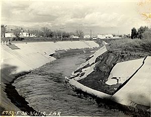
Some river channel work was already in place. However, the 1938 flood was the main reason for covering the Los Angeles River in concrete. This helps floodwaters flow faster to the sea. The project was approved in 1941 and started a few years after the flood. It was a huge job that took twenty years to complete. About 278 miles (447 km) of streams in the Los Angeles River system were put into concrete channels. This system successfully protected Los Angeles from massive flooding in 1969. The San Gabriel and Santa Ana Rivers were also eventually channelized to protect against future floods.
Because of the large mudslides during the 1938 flood, the U.S. Forest Service was given the job of preventing fires in the Angeles Forest. This was to reduce the risk of erosion in burned areas.
 | Leon Lynch |
 | Milton P. Webster |
 | Ferdinand Smith |


