Great Flood of 1862 facts for kids

|
|
| Date | December 1861 – January 1862 |
|---|---|
| Location | Washington, Oregon, Nevada, California, Idaho, Arizona, New Mexico, Baja California, Sonora, Mexico |
| Deaths | >4,000 |
| Property damage | $100 million (1861 USD) $3.117 billion (2021 USD) |
The Great Flood of 1862 was a massive flood that hit parts of the Western United States in late 1861 and early 1862. It was the biggest flood ever recorded in Oregon, Nevada, and California. Weeks of non-stop rain and heavy snow in the mountains caused this disaster.
The flood stretched from the Columbia River in Oregon all the way south through California to San Diego. It also reached inland to Idaho, Nevada, Utah, and Arizona. California alone received an incredible amount of rain and snow, like 10 feet (3.0 m) of water falling over 43 days! When the huge amount of snow in the mountains melted, it caused even more flooding in places like Idaho, Arizona, New Mexico, and parts of Mexico.
This event is known as the worst disaster to ever hit California. It caused about $100 million in damages back then, which would be over $3 billion today. The state government couldn't pay its workers for a year and a half. Sadly, over 4,000 people died in California, which was about 1% of the state's population at the time.
Contents
What Caused the Great Flood?
Scientists have studied old weather records to understand what caused this huge flood. It wasn't caused by an El Niño event. Instead, experts believe the heavy rain came from something called "atmospheric rivers."
Understanding Atmospheric Rivers
An atmospheric river is like a long, narrow river of water vapor that moves through the sky. It carries a lot of moisture from the tropics. When these "rivers" hit land, especially mountains, they can drop huge amounts of rain. If several atmospheric rivers hit the same area for a long time, like they did along the West Coast in 1861-1862, they can cause extreme flooding.
Before the flood, California had been in a 20-year-long drought. Then, in November 1861, Oregon started getting heavy rain and snow. By December, freezing conditions hit Oregon, and a huge weather system moved over California. It rained almost non-stop for nearly 40 days across the entire state. This even caused snow to fall in the Central Valley and nearby mountains.
How the Flood Impacted Different Regions
Oregon
Oregon experienced a lot of rain in November 1861, especially in the mountains. This snow later melted quickly due to warm rains, sending huge amounts of water into the Willamette River and other streams. The flood reached its highest points in early December in cities like Salem and Oregon City. It was the highest flood ever known in these areas.
The flood was especially bad in the Willamette Valley. Rivers were the main way people traveled and moved goods. Mills, warehouses, and homes were built close to the rivers. Many farms and their supplies were also near the water. All of this was swept away.
For example, at Oregon City, the water was so high that a steamboat could actually go over the falls! The town of Linn City was completely destroyed and never rebuilt. The historic town of Champoeg, where Oregon's first government was formed, was also wiped out. The loss of so much wheat and flour caused prices to skyrocket.
Idaho
In what is now Idaho, the same storm that caused rain in Oregon brought an incredible amount of snow. This snow, combined with flooding on the Columbia River, cut off supplies to new mining towns. Miners in Florence faced starvation from December until May 1862.
When the heavy mountain snow finally melted in July, it caused massive floods. The Boise River became several miles wide, much larger than any flood recorded since. It even washed away parts of the original Oregon Trail in the river valley.
California
California was hit by a mix of endless rain, snow, and then unusually warm temperatures. In Northern California, heavy snow fell in late November and early December. Then, the temperature rose sharply, and it started raining. There were four major periods of heavy rain between December and January. Native Americans had always known that the Sacramento Valley could turn into an "inland sea" when the rains came.
Northern California
Fort Ter-Waw was destroyed by the flood in December 1861. Bridges were washed away in Trinity and Shasta counties. At Weaverville, a witness described how the heavy rain quickly melted the snow, turning the Trinity River into a destructive monster. Everything along 150 miles of the river was swept away: bridges, mining equipment, cabins, and parts of ranches. The area never fully recovered from this disaster.
Central Valley
The entire Sacramento and San Joaquin valleys were completely underwater. This area was about 300 miles (480 km) long and 20 miles (32 km) wide, covering thousands of square miles. The water in the Central Valley was up to 30 feet (9.1 m) deep, completely covering telegraph poles that had just been put in. Travel, mail, and communication across the state were stopped for a month. Some parts of the valley stayed flooded from December 1861 through the spring and into the summer of 1862.
Many towns were submerged. In Knight's Ferry, homes, the mill, and most businesses were ruined. The bridge there was destroyed when debris from another bridge upstream crashed into it. Cities like Sacramento, Marysville, Santa Rosa, and Napa were partly underwater. Smaller towns like Empire City and Mokelumne City were completely destroyed.
Sacramento
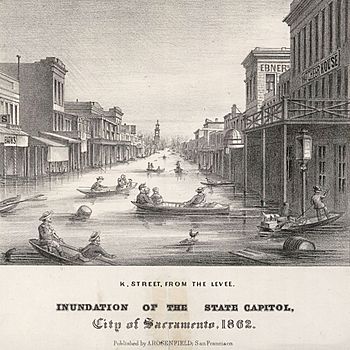
Sacramento, located where the Sacramento and American Rivers meet, was built on low ground. The city had levees (walls to hold back water), but these actually trapped the floodwaters inside the city. The water level inside Sacramento became 10 feet (3.0 m) higher than the river outside.
On January 10, 1862, the state's governor, Leland Stanford, had to travel by rowboat to his inauguration! Much of Sacramento stayed underwater for three months. Because of the flooding, the California State Legislature had to temporarily move to San Francisco while Sacramento was being rebuilt.
Levee Damage and City Rebuilding
The levees around Sacramento made the flooding worse because they held the water in. A chain gang was sent to break open the levee, which helped lower the water level in the city. The state capital was moved from Sacramento to San Francisco on January 23, 1862.
After the flood, Sacramento invested over $1.5 million to improve its flood control system. They re-channeled the American River and strengthened the levees. A 20-year project was started to raise the entire city above flood level. The Central Pacific Railroad helped with this huge effort, using its large Chinese workforce to rebuild the levees.
You can still see signs of this today. Many old Victorian buildings in Sacramento have raised front porches with stairs leading down to the street. This was a design to deal with floods. Old Town Sacramento was raised 15 feet (4.6 m) above flood level. If you go underground, you can find the ruins of the old city, with tunnels and filled-in entrances where streets and shops used to be.
Southern California
In Southern California, it rained for 28 days straight in Los Angeles. The mining town of Eldoradoville in the San Gabriel Mountains was washed away. Thousands of cattle drowned, and fruit trees and vineyards along the Los Angeles River were destroyed. Mail didn't reach Los Angeles for five weeks.
The plains of Los Angeles County became a huge lake system. The Santa Ana River created an inland sea that lasted about three weeks, with water 4 feet (1.2 m) deep for miles. The Los Angeles, San Gabriel, and Santa Ana Rivers merged into one giant body of water.
In Santa Barbara County, coastal plains were flooded. In San Bernardino County, the town of Agua Mansa was almost completely swept away by the Santa Ana River. Luckily, a church bell warned everyone, and they escaped.
In San Diego, the floodwaters changed the path of the San Diego River, creating a new channel into San Diego Harbor. The heavy rain also carved deep gullies and canyons into the previously rounded hills.
Economic Impact
The flood had a terrible impact on the economy. Over 100,000 sheep and 500,000 lambs died. Even oyster beds in San Francisco Bay were killed by the huge amount of freshwater and sediment. About a quarter of California's 800,000 cattle died, which sped up the end of the old cattle-based ranching way of life.
A quarter to a third of all property in California was destroyed. One out of every eight homes was either washed away or ruined. Mining equipment across the state was also swept away. The state almost went bankrupt because of the huge costs of the damage and the loss of tax money.
Nevada
The Carson River Basin in what is now Nevada also suffered from similar flooding. Heavy, wet snow fell in December 1861, followed by freezing temperatures. Then, a three-day rain began on December 25. By January 2, 1862, the town of Dayton was flooded.
In Aurora, after light snow, a huge, fast snowfall began on Christmas Eve. Temperatures dropped below zero, closing mountain passes. In January, it warmed slightly, and the snow turned into a torrential rain. Buildings made of adobe (mud bricks) turned to mud and collapsed. Then, it got cold again, and even more snow fell.
Utah
Early settlements in southwestern Utah were almost destroyed by a flood on the Virgin and Santa Clara Rivers. This flood followed 44 days of rain in January and February 1862. Survivors had to move and build new towns on higher ground. For example, Fort Harmony had to be abandoned when most of its adobe walls were washed away.
Arizona
In western New Mexico Territory (which included parts of modern-day Arizona), heavy rains in late January caused severe flooding of the Colorado River and Gila River. On January 22, 1862, the Colorado River rose nearly 6 feet (1.8 m) in just three hours, turning Fort Yuma in California into an island.
Towns like Jaeger City and Colorado City were washed away. The Gila River also flooded its entire valley where it met the Colorado. Most of the mining town of Gila City was swept away. The flood also drowned much livestock and destroyed crops belonging to Native American tribes along the rivers.
The floodwaters from the Colorado River even reached the Salton Sink, creating a huge lake about 60 miles (97 km) long and 30 miles (48 km) wide.
New Mexico
The massive snowpack in the southern Rocky Mountains during the winter of 1861-62 caused a huge spring flood in the Rio Grande. This flood actually changed the river's course in the Mesilla Valley. The flood also made it harder for the California Column (a Union Army group) to chase the retreating Confederate Army. The town of Mesilla, which was built on the west bank of the Rio Grande, ended up on the east bank after the river changed its path.
Sonora, Mexico
Before the Great Flood of 1862, what is now Port Isabel Slough in Sonora, Mexico, was a shallow channel. But the extreme floodwaters made it much deeper. This made it a perfect place for ships to anchor safely, away from the strong tides of the Colorado River.
In 1865, a schooner (a type of sailing ship) called the Isabel found this deep channel. Soon, steamboats and other ships started using it to load and unload their cargo. A port called Port Isabel was built there. However, the port was abandoned in 1878 after the Southern Pacific Railroad reached Yuma, making river transport less important.
Could a Similar Flood Happen Again?
The Great Flood of 1862 was not a one-time event. Geologists have found evidence that massive floods, just as big or even bigger, have happened in California roughly every 100 to 200 years.
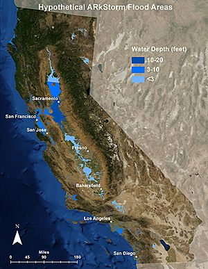
The United States Geological Survey has created a hypothetical scenario called the "ARkStorm" (Atmospheric River 1,000-year Storm). This scenario imagines what would happen if a similar flood occurred in California today. If such a storm were to happen, it could cause over $725 billion to $1 trillion in damages. It might also lead to over 400,000 deaths, similar to the 1% of the population that died in the 1862 flood. This shows how important it is to be prepared for such natural disasters.
 | Claudette Colvin |
 | Myrlie Evers-Williams |
 | Alberta Odell Jones |


