Los Angeles River facts for kids
Quick facts for kids Los Angeles River |
|
| El Rio De Nuestra Senora La Reina De Los Angeles De Porciuncula, Porciuncula River |
|
| River | |
|
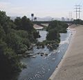
The Los Angeles River flowing through the Glendale Narrows, a mountain pass in Los Angeles
|
|
| State | California |
|---|---|
| Region | Los Angeles County |
| Tributaries | |
| - left | Aliso Wash, Tujunga Wash, Arroyo Seco, Rio Hondo |
| - right | Compton Creek |
| Source | San Fernando Valley |
| - location | Confluence of Bell Creek and Calabasas Wash |
| Secondary source | San Gabriel Mountains |
| Mouth | San Pedro Bay |
| Length | 82 km (51 mi) |
The Los Angeles River is a river in Los Angeles County, California, United States. People also call it the LA River. Its full Spanish name is El Rio De Nuestra Senora La Reina De Los Angeles De Porciuncula, which means "The River of Our Lady Queen of the Angels of Porciúncula."
The river is about 51 miles (82 km) long. It starts in Canoga Park and flows south and west. It ends at the Long Beach Harbor, which is part of the Pacific Ocean. Mountains like the San Gabriel Mountains and Santa Monica Mountains surround the river's area. Most of the water in the river comes from smaller streams, called tributaries, that flow down from these mountains.
Long ago, the river flowed freely and changed its path often. It would flood and move dirt around. When Los Angeles was first settled around the 1850s, the river was the main source of water. But after the Los Angeles Aqueduct opened in 1913, the river was no longer needed for drinking water. Today, most of the Los Angeles River flows in a fixed path. It is mostly covered in concrete. The river gets a lot of its water from a water treatment plant in Van Nuys. Plans are being made to make the river more natural again.
Contents
Exploring the River's Path
The area that drains into the Los Angeles River is called its watershed. This watershed covers 834 square miles (2,135 square kilometers). The Santa Monica Mountains are on one side, and the San Gabriel Mountains are on the other. Seven main tributaries flow into the Los Angeles River. These include Tujunga Wash, Arroyo Seco, and Rio Hondo. About 360 square miles (920 square kilometers) of the watershed are open spaces. The rest is developed with buildings and roads.
The river officially starts in Canoga Park, in the San Fernando Valley. Two streams, Bell Creek and Calabasas Wash, meet to form the river. At this point, the river already flows in a concrete channel. During floods, the water can move very fast, up to 45 miles (72 km) per hour.
Several streams like Tujunga Wash join the river. The river then flows into a place called the Sepulveda basin. A dam controls this basin. This area is full of wildlife and plants. Normally, water would not flow here all year. However, a water plant adds 75 million gallons of water daily. This water is safe to touch but not for drinking.
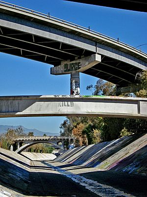
Another important stream, Verdugo Wash, joins the river. It starts in the Verdugo Hills. The river then bends west around Griffith Park, a large park in Los Angeles. Here, the river has a natural dirt bottom, which is special since most of it is concrete. Further downstream, there's a place called "Frogtown." Many frogs used to live there. The Arroyo Seco joins the river next. Its name means "dry creek" in Spanish. The Arroyo Seco starts in the San Gabriel Mountains. It has a large Devil's Gate Dam.
As the Los Angeles River gets closer to the San Pedro Bay and the Pacific Ocean, it becomes very wide. The last big tributary, Rio Hondo (meaning "deep river" in Spanish), joins the river in South Gate. The ground here is very deep with dirt and sand. Floods are a constant worry here. In a 1992 flood, the water almost reached the top of the riverbanks. Near its end, the river passes by the RMS Queen Mary, a famous ship that is now a museum and hotel.
River History
The River's Natural State
The Los Angeles River used to flow freely across a wide area. It would often flood. In winter and spring, it had strong flows due to rain. In summer and fall, it had little to no water. However, water from underground sources (an aquifer) kept some parts of the river flowing all year. You can still see this today in Griffith Park, where water naturally comes up from the ground.
From Native Americans to Spanish Settlers
For hundreds of years, Native Americans used the river for drinking water and food. In the 1760s, Spanish explorers arrived. They named the river Porciuncula, thinking it was a good spot for a town. Its full name was El Río de Nuestra Señora La Reina de Los Ángeles de Porciúncula. This means "The River of Our Lady Queen of the Angels of Porciúncula." Porciúncula is a small church in Italy.
The Spanish soon learned that the Los Angeles River often flooded. When it flooded, it would sometimes change its path. In a big flood in 1825, the river moved from flowing into Ballona Creek to its old path into San Pedro Bay. Ballona Creek then became a separate waterway.
Changes in the Late 1800s and Early 1900s
The city of Los Angeles grew next to the river. In 1889, San Pedro Bay, where the river meets the ocean, was chosen as the city's harbor. Railroads were built along the river to connect the city to the port. Factories and businesses also grew along the river. Because of its bad flood history and being too shallow for boats, the river was put into a concrete channel starting in 1938.
The Great Flood of 1938
In 1938, a terrible flood hit the area. From February 27 to March 1, a big storm brought over 4.4 inches (11 cm) of rain. This was a quarter of the average yearly rainfall. The rain stopped on March 4, and the water levels began to drop. People thought the flood was over. But 15 hours later, another storm hit, bringing 6-10 inches (15-25 cm) more rain. The ground could not soak up any more water. The Los Angeles, San Gabriel, and Santa Ana rivers overflowed their banks. They flooded three California counties.
This was the fifth largest flood in the area's history. Over 5,600 houses were destroyed, and 1,500 were damaged. Los Angeles County was not hit as hard as Riverside County and Orange County.
Luckily, 14 flood control dams in the mountains held back huge amounts of water. These dams included Hansen Dam and Big Tujunga Dam. Without them, the flood would have been much worse. At its highest, the Los Angeles River's flow was about 38,000 cubic feet (1,076 cubic meters) per second. The nearby San Gabriel River flowed even faster.
Efforts to Restore the River
Recently, many people want to change the river back to its natural state. Groups like Friends of the Los Angeles River (FoLAR) have been formed to help.
The Los Angeles River Master Plan was created in 1991. It aims to restore a large part of the river and one of its tributaries, the Tujunga Wash. A famous mural called the Great Wall of Los Angeles is painted on the wall of the Tujunga Wash. The plan also wants to improve fun activities, health, property value, the environment, and education for people living near the river. They plan to build many parks. This will add more open space to Los Angeles. The city has only 4% open space, which is very low compared to other cities like Boston (9%).
In 2007, the City of Los Angeles decided to spend about $2 billion USD over the next 50 years. This money will pay for over 200 projects. These include new parks, walkways, and pedestrian bridges along 31 miles (50 km) of the river. Some old factories will be removed so that new homes can be built closer to the river.
Cities Along the River
The biggest city along the Los Angeles River is Los Angeles. Many other cities and towns are also located next to the river.
|
col-end}} Bridges Over the RiverMany bridges cross the Los Angeles River. Here are some of them, listed from south to north:
Nearby RiversNorth along coastSouth along coastImages for kids
See also
|
 | Precious Adams |
 | Lauren Anderson |
 | Janet Collins |






 In Spanish: