
Interstate 710 and State Route 710 (California) facts for kids
Quick facts for kids
[[File:|x70px|alt= marker]] |
||||
|---|---|---|---|---|
| Long Beach Freeway | ||||
| Lua error in Module:Infobox_road/map at line 15: attempt to index field 'wikibase' (a nil value).
I-710 and SR 710 highlighted in red
|
||||
| Route information | ||||
| Defined by S&HC § 622 | ||||
| Length | 23 mi (37 km) | |||
| History | 1930s as highway, 1964 as a number (SR 7), 1983-1984 as an interstate (I-710) | |||
| Component highways |
|
|||
| Main section | ||||
| South end | ||||
| Major junctions |
|
|||
| North end | Valley Boulevard in Alhambra | |||
| Pasadena stub | ||||
| South end | California Boulevard in Pasadena | |||
| North end | ||||
| Location | ||||
| Counties: | Los Angeles | |||
| Highway system | ||||
| State highways in California(list • pre-1964) History • Unconstructed • Deleted • Freeway • Scenic
|
||||
Interstate 710 (I-710) and State Route 710 (SR 710) are two important highways in Los Angeles County, California. They are like two parts of the same road, even though they don't quite connect. Both highways run in a north-south direction.
The main part, I-710, is also known as the Long Beach Freeway. It starts near the Port of Los Angeles in Long Beach. From there, it travels north along the Los Angeles River to East Los Angeles. The freeway then continues north, ending near Interstate 10 in Alhambra.
The shorter part, State Route 710, is in Pasadena. It begins at California Boulevard and heads north. This short section connects to Interstate 210. Together, these two highways stretch for about 23 miles (37 kilometers).
Contents
About Interstate 710
Where Does it Go?
The I-710 freeway is a major route for people and goods in Los Angeles County. It helps connect the busy Port of Long Beach and Port of Los Angeles to other parts of the county. This makes it very important for trade and transportation.
The freeway follows the path of the Los Angeles River for a good portion of its journey. It passes through many cities, including Long Beach, Lynwood, Commerce, and East Los Angeles.
Key Connections
Highways often connect to other major roads, and I-710 is no different. It links up with several other important freeways in California. These connections help drivers get to many different places across the region.
Here are some of the main freeways that connect with I-710:
- California State Route 1 (Pacific Coast Highway)
- Interstate 405 (San Diego Freeway)
- State Route 91 (Artesia Freeway)
- Interstate 105 (Century Freeway)
- Interstate 5 (Santa Ana Freeway)
- State Route 60 (Pomona Freeway)
- Interstate 10 (San Bernardino Freeway)
The Pasadena Stub
The SR 710 section in Pasadena is often called the "Pasadena stub." It's a short, unsigned highway. This means it doesn't have the usual SR 710 signs. It connects to Interstate 210 and State Route 134.
This part of the highway has been a topic of discussion for many years. There were plans to connect it fully to the main I-710, but these plans were never completed.
History of the Highway
The idea for this highway goes back to the 1930s. It was first planned as a regular highway. Later, in 1964, it was given the number State Route 7.
In the 1980s, between 1983 and 1984, the main section of the highway became an Interstate. This is why it's now called I-710. Interstates are part of a national system of highways.
The gap between the I-710 and the SR 710 in Pasadena is known as the "South Pasadena Gap." This gap has been a long-standing issue. Different ideas were suggested to close it, including building a tunnel. However, none of these plans were ever finished.
Images for kids
-
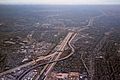
Aerial view of the I-105/I-710 interchange
-
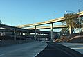
I-710 at its junction with SR 60 in East Los Angeles
-
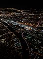
Night aerial view of the Los Angeles River where I-710 converges on it (from the right) at the City of Commerce
-
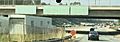
Southern onramp, I-710 northern stub, near downtown Pasadena. Notice the empty road sign structures.


See also
 In Spanish: Interestatal 710 para niños
