
Interstate 210 and State Route 210 (California) facts for kids
Quick facts for kids
[[File:|x70px|alt= marker]] |
||||
|---|---|---|---|---|
| Foothill Freeway | ||||
| Lua error in Module:Infobox_road/map at line 15: attempt to index field 'wikibase' (a nil value).
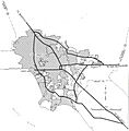
Route 210 highlighted in red
|
||||
| Route information | ||||
| Defined by S&HC § 510 | ||||
| Maintained by Caltrans | ||||
| Length | 85 mi (137 km)
Length includes the unconstructed portion of I-210.
|
|||
| History | Route proposed 1933 Designated 210 in 1964 |
|||
| Component highways |
||||
| Major junctions | ||||
| West end | ||||
|
||||
| East end | ||||
| Location | ||||
| Counties: | Los Angeles, San Bernardino | |||
| Highway system | ||||
| State highways in California(list • pre-1964) History • Unconstructed • Deleted • Freeway • Scenic
|
||||
The Interstate 210 (I-210) and State Route 210 (SR 210) are two important highways in California. They are both part of what is known as the Foothill Freeway. This long road helps people travel across Los Angeles and San Bernardino counties.
The Foothill Freeway starts near Santa Clarita and San Fernando at Interstate 5. It then travels east, passing through many cities. When it reaches San Dimas at State Route 57, its name changes from Interstate 210 to State Route 210. It continues east until it ends at Interstate 10 in Redlands. Together, these highways stretch for about 85 miles (137 kilometers).
Contents
What is the Foothill Freeway?
The Foothill Freeway is a major road system in Southern California. It's special because it's made up of two different types of highways. One part is an Interstate Highway, which is a big road that's part of a national network. The other part is a State Route, which is managed by the state of California.
Why is it called the Foothill Freeway?
This freeway gets its name because it runs along the base of the San Gabriel Mountains. These mountains are part of the "foothills" of California. So, the name "Foothill Freeway" perfectly describes where this road is located. It offers great views of the mountains as you drive!
How long is the Foothill Freeway?
The entire Foothill Freeway, combining both I-210 and SR 210, is about 85.31 miles (137.30 kilometers) long. This makes it one of the longer freeways in the region. It helps connect many communities and makes travel easier for thousands of people every day.
Where Does the Freeway Go?
The Foothill Freeway connects many cities and towns in Southern California. It starts in the western part of Los Angeles County and stretches all the way to San Bernardino County in the east.
Major Cities Connected
The freeway passes through or near several important cities:
Important Connections
Along its path, the Foothill Freeway connects with many other major roads. These connections help drivers get to even more places. Some of the important highways it meets include:
- Interstate 5 (I-5)
- State Route 118 (SR 118)
- State Route 2 (SR 2)
- State Route 134 (SR 134)
- Interstate 605 (I-605)
- State Route 57 (SR 57)
- Interstate 15 (I-15)
- Interstate 215 (I-215)
- Interstate 10 (I-10)
These connections make the Foothill Freeway a vital part of the transportation system in Southern California.
History of the Freeway
The idea for this important road was first suggested a long time ago, in 1933. It took many years for the plans to become a reality.
When was it built?
The route was officially named "Route 210" in 1964. Construction happened in different stages over several decades. Building a freeway this long and complex takes a lot of time and effort. Engineers and construction workers had to overcome many challenges to complete it.
The Glendora Curve
One interesting part of the freeway is called the "Glendora Curve." This is where Interstate 210 ends and State Route 210 begins. It's a key point where the highway changes its official designation. This curve is located near the city of Glendora.
Images for kids
-
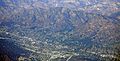
I-210 in La Crescenta-Montrose, below Mount Lukens; intersection with Glendale Freeway at lower right-center
-
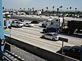
Foothill Freeway as seen from the Metro Gold Line, Sierra Madre Villa Station
-
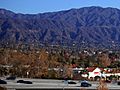
Elevated portion of freeway in Monrovia
-
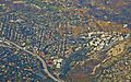
I-210 in La Cañada Flintridge; Jet Propulsion Laboratory on the right
-
1955 map of the planned Interstates in the Greater Los Angeles Area. The original proposal for present-day I-210 includes its original eastern terminus in Pomona.


See also
 In Spanish: Interestatal 210 y Ruta Estatal 210 para niños
