
San Fernando, California facts for kids
Quick facts for kids
San Fernando, California
|
||
|---|---|---|
|
|
||
|
||
| Country | ||
| State | ||
| County | Los Angeles | |
| Incorporated | August 31, 1911 | |
| Named for | St. Ferdinand | |
| Government | ||
| • Type | Council-Manager | |
| Area | ||
| • Total | 2.37 sq mi (6.15 km2) | |
| • Land | 2.37 sq mi (6.15 km2) | |
| • Water | 0.00 sq mi (0.00 km2) 0% | |
| Elevation | 1,070 ft (326 m) | |
| Population
(2020)
|
||
| • Total | 23,946 | |
| • Estimate
(2022)
|
23,685 | |
| • Density | 10,086.80/sq mi (26,124.69/km2) | |
| Time zone | UTC-8 (PST) | |
| • Summer (DST) | UTC-7 (PDT) | |
| ZIP Code |
91340-91342, 91344-91346
|
|
| Area code(s) | 818, 747 | |
| FIPS code | 06-66140 | |
| GNIS feature IDs | 1652786, 2411785 | |

,_San_Fernando,_CA.JPG)


San Fernando is a city in Los Angeles County, California. Its name comes from St. Ferdinand in Spanish. It's located in the San Fernando Valley and is surrounded by the City of Los Angeles. In 2020, about 23,946 people lived there.
Contents
San Fernando's Past
_(CHS-9501).jpg)
Before Spanish explorers arrived, the area was home to Native American groups. The Tongva people lived in the northwestern part of their lands, called Tovaangar. A large Tongva village called Pasheeknga was nearby. The Tataviam lived to the north, and the Chumash to the west.
Spanish Rule and Missions
The Mission San Fernando Rey de España was started in 1797. It was named after St. Ferdinand. This mission was built on a farming area called Achooykomenga. Workers from the Ventureño Chumash, Fernandeño (Tongva), and Tataviam tribes worked there.
In 1833, the Mexican government took control of the mission lands. During the mission's time, many Native American children were baptized there. Sadly, many children and adults died, which sometimes caused people to run away.
Ranchos and Land Sales
In 1846, the area became part of a large Mexican land grant. This grant was called Rancho Ex-Mission San Fernando. Later, in 1874, a man named Charles Maclay bought a big part of this land. He bought about 56,000 acres (227 square kilometers).
In 1882, two cousins, George K. Porter and Benjamin F. Porter, each got a third of the land. In 1885, Maclay started a school for religious studies. This school later moved and became part of other universities.
Many towns in the San Fernando Valley joined Los Angeles in the 1910s. They wanted to get water from the new Los Angeles Aqueduct. But San Fernando had its own water from underground. This allowed it to stay a separate city.
Becoming a City
San Fernando officially became a city in 1911. In the early 1900s, the city tried to grow its borders. It wanted to include nearby areas like Sylmar and Pacoima. However, Los Angeles was also growing fast and annexed many of these areas.
By the 1950s, San Fernando found it hard to annex new land. This was because Los Angeles had a very large government system. After World War II, the San Fernando Valley changed from farms to suburbs. San Fernando kept its independence during this time.
Recently, the population of San Fernando has changed. Many middle-class white families, who were common in the 1950s, have moved to other parts of the valley. Some have also moved to the Santa Clarita Valley and Antelope Valley to the north.
Location and Weather
San Fernando is completely surrounded by the Los Angeles city. The neighborhoods around it are Sylmar to the north, Lake View Terrace to the east, Pacoima to the south, and Mission Hills to the west. Major freeways like the Golden State (Interstate 5) and Ronald Reagan (State Route 118) serve the city.
| Climate data for San Fernando, California | |||||||||||||
|---|---|---|---|---|---|---|---|---|---|---|---|---|---|
| Month | Jan | Feb | Mar | Apr | May | Jun | Jul | Aug | Sep | Oct | Nov | Dec | Year |
| Record high °F (°C) | 92 (33) |
92 (33) |
98 (37) |
103 (39) |
105 (41) |
114 (46) |
113 (45) |
112 (44) |
114 (46) |
106 (41) |
97 (36) |
90 (32) |
114 (46) |
| Mean daily maximum °F (°C) | 66 (19) |
68 (20) |
70 (21) |
75 (24) |
78 (26) |
84 (29) |
92 (33) |
93 (34) |
88 (31) |
81 (27) |
72 (22) |
66 (19) |
78 (26) |
| Mean daily minimum °F (°C) | 43 (6) |
45 (7) |
44 (7) |
46 (8) |
51 (11) |
55 (13) |
58 (14) |
60 (16) |
58 (14) |
53 (12) |
46 (8) |
43 (6) |
50 (10) |
| Record low °F (°C) | 23 (−5) |
26 (−3) |
28 (−2) |
30 (−1) |
32 (0) |
36 (2) |
40 (4) |
41 (5) |
39 (4) |
31 (−1) |
28 (−2) |
26 (−3) |
23 (−5) |
| Average precipitation inches (mm) | 4.14 (105) |
4.52 (115) |
3.85 (98) |
0.96 (24) |
0.25 (6.4) |
0.07 (1.8) |
0.03 (0.76) |
0.15 (3.8) |
0.34 (8.6) |
0.52 (13) |
1.48 (38) |
2.27 (58) |
18.58 (472) |
People of San Fernando
| Historical population | |||
|---|---|---|---|
| Census | Pop. | %± | |
| 1920 | 3,204 | — | |
| 1930 | 7,567 | 136.2% | |
| 1940 | 9,094 | 20.2% | |
| 1950 | 12,992 | 42.9% | |
| 1960 | 16,093 | 23.9% | |
| 1970 | 16,571 | 3.0% | |
| 1980 | 17,731 | 7.0% | |
| 1990 | 22,580 | 27.3% | |
| 2000 | 23,564 | 4.4% | |
| 2010 | 23,645 | 0.3% | |
| 2020 | 23,946 | 1.3% | |
| 2022 (est.) | 23,685 | 0.2% | |
| U.S. Decennial Census | |||
Population in 2020
In 2020, San Fernando had 23,946 residents. Most people (93.2%) were of Hispanic or Latino background. About 4.2% were non-Hispanic White, and 2.3% were Asian. The city had about 10,086 people per square mile.
The population was split evenly between males and females. About 23.1% of residents were under 18 years old. About 11.8% were 65 or older. The average age in San Fernando was about 33.9 years.
The average household income was $77,334. Most residents (73.1%) speak a language other than English at home. About 71.2% speak Spanish at home.
Population in 2010
In 2010, San Fernando had 23,645 people. The population density was about 9,960 people per square mile. Most residents (92.5%) were Hispanic or Latino.
About 99.5% of people lived in homes. There were 5,967 households in total. Over half of these (54.4%) had children under 18. The average household had about 3.94 people.
The age groups were: 29.4% under 18, 11.2% aged 18 to 24, and 30.2% aged 25 to 44. The median age was 30.7 years. For every 100 females, there were about 100.7 males.
About 54.5% of homes were owned by the people living in them. The rest were rented. The average household income was $55,192. About 16.9% of the population lived below the poverty line.
Population in 2000
In 2000, San Fernando had 23,564 people living in 5,774 households. The population density was about 9,880 people per square mile. About 89.28% of residents were Hispanic or Latino.
Over half of the households (52.8%) had children under 18. The average household size was 4.07 people. The average family size was 4.33 people.
About 34.4% of the population was under 18. The median age was 27 years. For every 100 females, there were about 101.7 males.
The average household income was $39,909. About 19.1% of the population lived below the poverty line. This included 22.5% of those under 18.
San Fernando's Economy
Major Employers
The city's 2022 report lists the top ten employers. These do not include the city government itself.
| # | Employer | # of Employees |
|---|---|---|
| 1 | Los Angeles Unified School District | 2145 |
| 2 | Pharmavite LLC | 343 |
| 3 | Pepsi Bottling Company | 320 |
| 4 | Home Depot | 300 |
| 5 | County of Los Angeles | 250 |
| 6 | PureTek | 196 |
| 7 | Production Resource Group LLC | 151 |
| 8 | Northeast Valley Health Group | 150 |
| 9 | Vallarta Supermarkets | 144 |
| 10 | Ricon Corp | 118 |
In 2021, San Fernando had 11,000 people in its workforce. About 35.85% of them worked for the top ten employers listed above. The City of San Fernando government also employed 132 people in 2021.
Arts and Fun Activities
The city hosts many public events. These include July 4 celebrations and summer movie nights in local parks. Mexican-American culture is very important here. The city holds Día de los Muertos festivals. It also offers community classes that teach Aztec and Folklórico dances.
Sports in San Fernando
San Fernando has an ulama team called Oceyolotl de San Fernando Valley. Ulama is an ancient ballgame. They play a version called ulama de cadera in a league called AJUPEME USA.
Parks and Recreation
The San Fernando Recreation and Community Services (RCS) Department manages the city's parks. They also run recreation centers. They offer fun activities and services for residents. There are social clubs for older residents. These clubs offer crafting, gardening, and social events.
| Name | Address | Notes |
|---|---|---|
| Casa de López Adobe | 1100 Pico Street | A small park on a historic site. |
| César E. Chávez Memorial Park | Wolfskilll Street & Truman Street | A park honoring César E. Chávez at a city entrance. |
| Las Palmas Park | 505 South Huntington Street | A neighborhood park with sports fields and fun areas. |
| Layne Park | 120 North Huntington Street | A small neighborhood park with places to play. |
| Pioneer Park | 828 Harding Street | A neighborhood park with sports facilities. |
| Rudy Ortega Sr. Park | 2025 Fourth Street | A neighborhood park with walking paths and a tea house. |
| San Fernando Recreation Park | 208 Park Avenue | Also known as San Fernando Regional Park; has sports fields and a recreation center. |
| San Fernando Regional Pool | 300 Park Avenue | Public swimming pools next to San Fernando Recreation Park. |
| Cindy Montañez Natural Park | 801 8th Street | Used to be Pacoima Wash Natural Park; has walking trails and a picnic area. |
Education in San Fernando


The Los Angeles Unified School District (LAUSD) serves San Fernando.
Here are some LAUSD schools in San Fernando:
- O'Melveny Elementary School
- Morningside Elementary School
- San Fernando Elementary School
- San Fernando Middle School
- San Fernando Institute for Applied Media
- César Chávez Learning Academies
- San Fernando High School
- Vaughn International Studies Academy (VISA); a Charter School
The closest community college is Los Angeles Mission College in Sylmar.
PUC Schools runs some charter schools in San Fernando. These include Nueva Esperanza Charter Academy (middle and high school) and PUC Inspire Charter Academy.
Public Library

The County of Los Angeles Public Library has a branch in San Fernando. It is located at 217 North Maclay Avenue.
City Services
The Los Angeles County Department of Health Services runs the Pacoima Health Center. This center is in Pacoima and serves San Fernando.
San Fernando manages its own water supply. The city builds and maintains systems for water. In 2022, the city started building a large rainwater system. This system will help clean the Pacoima Wash and the Los Angeles River. It will also help refill underground water supplies. This project will also reduce flooding during heavy rains. A baseball field will be built on top of the new system.
The United States Postal Service has a post office in San Fernando.
Police Department

The San Fernando Police Department provides police services. It has 35 sworn police officers and 25 other staff. There are also 20 reserve police officers. In total, the department can use 55 sworn officers when needed.
The San Fernando Police Department is part of a disaster management group. This group includes cities like Burbank, Pasadena, and Glendale. The San Fernando Police have asked the LAPD for help during big events in the past.
Fire Department
The Los Angeles Fire Department protects San Fernando from fires. They have three fire stations nearby. These stations are located in the City of Los Angeles.
Station 75 in Mission Hills serves western San Fernando. Station 91 in Sylmar serves northeast San Fernando. Station 98 in Pacoima serves southeast San Fernando.
Transportation
The Sylmar/San Fernando Metrolink station serves the city. This train line runs next to San Fernando Boulevard. City officials are concerned about the California High-Speed Rail project. They worry it might use the same route through the city. San Fernando will be the northern end of the new East San Fernando Valley Light Rail Transit Project by 2027. This will be the valley's first light rail line.
Famous People from San Fernando
- Paula Abdul, a television personality
- Don Prudhomme, a drag racing driver
- George Lopez, a comedian and actor
- Marlyn Mason, an actress
- David Wark Griffith, a pioneer in silent movies
- Joey Olivo, a world champion boxer
Images for kids
-
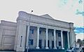
San Fernando Middle School Auditorium
-
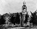
Maclay School of Theology, in San Fernando around 1890.
-
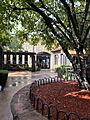
San Fernando branch library
-
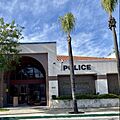
San Fernando Police Department
See also
 In Spanish: San Fernando (California) para niños
