Pacoima Wash facts for kids
Quick facts for kids Pacoima Wash |
|
|---|---|

Pacoima Wash in Panorama City
|
|
| Country | United States |
| Physical characteristics | |
| Main source | Pacoima Dam, California 1,990 feet (610 m) |
| River mouth | Tujunga Wash, California |
The Pacoima Wash is a stream in Los Angeles County, California. It is about 33 miles (53 km) long. This wash is a major tributary (a smaller stream that flows into a larger one) of the Tujunga Wash. The Tujunga Wash then flows into the Los Angeles River. Both are in the San Fernando Valley area.
The Pacoima Wash starts high up on Mount Gleason in the western San Gabriel Mountains. This area is part of the Angeles National Forest. The upper part of the stream is sometimes called Pacoima Creek. It flows quickly through Pacoima Canyon like a mountain stream.
Then, the water reaches the Pacoima Dam Reservoir. Below the dam, it is usually called the Pacoima Wash. From there, it collects water from other small streams coming from the nearby mountains. This water gathers at the Lopez Dam.
South of the Lopez Dam, the Pacoima Wash flows through a special concrete channel. This channel helps control floods. The wash travels south through several communities. These include Sylmar, San Fernando, Pacoima, Mission Hills, Panorama City, and Van Nuys.
After passing Interstate 5, part of the stream branches off. This part is called the Pacoima Diversion Channel. It joins the Tujunga Wash further upstream. Another small channel also branches off to join the Tujunga Wash. The main Pacoima Wash continues on. It goes through a storm drain to join the Tujunga Wash even further south.
Changes to the Pacoima Wash
The Pacoima Wash has changed a lot over the years. In 1991, a section of the wash between Lassen Street and Parthenia Street was made into a concrete channel. This was one of the last natural stream beds in the San Fernando Valley to be changed.
In 2007, the wash was cleaned up. This was because it was a place where mosquitoes carrying the West Nile virus were breeding. Cleaning the wash helped stop the spread of the virus.
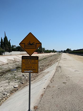
The Pacoima Wash can be dangerous, especially when it rains a lot. The water can flow very fast. There have been several times when people, often children and teenagers, had to be rescued from the fast-moving water. These rescues happened in 1985, 1993, 1995, 1996, 1998, and 2006. It is important to stay safe and away from the wash during heavy rains.
Creating Green Spaces
In recent years, people have been working to create a "greenway" along the Pacoima Wash. A greenway is a path or park area that connects different communities. The goal is to make the wash a nicer place for people and nature.
In 2004, a plan called the Pacoima Wash Greenway Master Plan was created. This plan focused on the part of the wash in the City of San Fernando.
In 2008, an environmental group called Pacoima Beautiful started the Pacoima Wash initiative. Their goal is to build a long greenway. This greenway would have bike lanes and walking paths. It would stretch about 12 miles (19 km) along the wash. This path would go from the Pacoima Dam in Sylmar to the Tujunga Wash in Arleta.
A plan for the Sylmar and Pacoima parts of the wash was made in 2011. Another part of the plan, focusing on the Arleta area, is being created now.
Several new parks are also being built along the wash. The 8th Street Park, which is about 4.75 acres (1.9 hectares), is in the City of San Fernando. It was finished in the spring of 2014. The city of Los Angeles is also designing a new park along the wash between El Dorado and Telfair Street. These parks will give people more places to enjoy nature and be active.
Crossings and Tributaries
Many roads, bridges, and train lines cross over the Pacoima Wash. Some smaller streams also join it. Here are some of the crossings and joining points, listed from the mouth (where it ends) to the source (where it begins):
- Van Nuys Boulevard (built in 1948)
- Saticoy Street (built in 1933)
- Raymer Street
- Railroad: Union Pacific Coast Line
- Unnamed channel departs
- Roscoe Boulevard (built in 1957)
- Chase Street (Pedestrian Bridge)
- Parthenia Street
- Rayen Street (built in 1996)
- Nordhoff Street
- Tupper Street (Pedestrian Bridge)
- Plummer Street
- Lassen Street
- Parking lot
- Woodman Avenue
- Devonshire Street and Pacoima Spreading Grounds
- Arleta Avenue
- Pacoima Diversion Channel departs
- Interstate 5 (also known as the Golden State Freeway) and Paxton Street ramps (built in 1963 and 1976)
- Laurel Canyon Boulevard (built in 1954)
- State Route 118 (Ronald Reagan Freeway) (built in 1969)
- San Jose Street/Haddon Avenue (Pedestrian Bridge)
- San Fernando Road (built in 1925)
- Railroad: Metrolink Antelope Valley Line
- Bradley Avenue/4th Street (built in 1954)
- 5th Street (built in 1953)
- Glenoaks Boulevard (built in 1953)
- Foothill Boulevard (built in 1923)
- Interstate 210 (Foothill Freeway) (built in 1975)
- Lopez Dam
- Harding Street
- Gavina Avenue
- Pacoima Trail Road and private roads
 | Emma Amos |
 | Edward Mitchell Bannister |
 | Larry D. Alexander |
 | Ernie Barnes |

