
Pacoima, Los Angeles facts for kids
Quick facts for kids
Pacoima
|
|
|---|---|

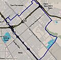
Boundaries of Pacoima as drawn by the Los Angeles Times
|
|

Pacoima
Location in San Fernando Valley

Pacoima
Location in the Los Angeles metropolitan area
|
|
| Country | United States |
| State | California |
| County | Los Angeles |
| City | Los Angeles |
| Time zone | UTC−8 (PST) |
| • Summer (DST) | UTC−7 (PDT) |
| ZIP Codes |
91331, 91333–91334
|
| Area code(s) | 818, 747 |
Pacoima is a neighborhood in Los Angeles, California. Its name comes from the Tataviam language word Pakoinga, which means "entrance." It's one of the oldest neighborhoods in the San Fernando Valley area of Los Angeles.
Contents
- Exploring Pacoima's Geography
- Pacoima's Rich History
- Pacoima's Economy and Community Spirit
- Pacoima's Population and People
- Getting Around Pacoima (Transportation)
- Fun and Games (Parks and Recreation)
- Learning in Pacoima (Education)
- Places of Worship
- Famous People from Pacoima
- Images for kids
- See also
Exploring Pacoima's Geography
Where is Pacoima Located?
Pacoima is surrounded by other Los Angeles areas. To its west is Mission Hills. Arleta is to the south, and Sun Valley is to the southeast. On the northeast, you'll find Lake View Terrace. The city of San Fernando borders Pacoima to the north.
Pacoima covers an area of about 7.14 sq mi (18.5 km2).
Pacoima's Changing Landscape
In the 1950s, Pacoima was a mix of older homes and dirt roads. Many areas lacked basic things like paved sidewalks and curbs. Over time, the community worked to improve these conditions.
Around 1955, a project began to add 9 mi (14 km) of new streets, sidewalks, and curbs. Local businesses even helped by creating a bank to fund improvements. This showed a strong desire to make Pacoima a better place to live.
By the 1960s, city planners suggested creating smaller shopping areas. They also wanted to improve sidewalks and plant more trees. The goal was to give Pacoima a stronger sense of community.
In the 1990s, Pacoima's main shopping street, Van Nuys Boulevard, had few empty stores. Many businesses were small shops and services. Despite challenges, residents showed great pride in their homes and community.
Pacoima's Climate
Pacoima has a warm climate, typical of Southern California. Summers are hot and dry, while winters are mild with some rain.
| Climate data for Pacoima, Los Angeles | |||||||||||||
|---|---|---|---|---|---|---|---|---|---|---|---|---|---|
| Month | Jan | Feb | Mar | Apr | May | Jun | Jul | Aug | Sep | Oct | Nov | Dec | Year |
| Mean daily maximum °F (°C) | 67 (19) |
69 (21) |
70 (21) |
75 (24) |
78 (26) |
84 (29) |
91 (33) |
92 (33) |
88 (31) |
82 (28) |
73 (23) |
67 (19) |
78 (26) |
| Mean daily minimum °F (°C) | 44 (7) |
45 (7) |
46 (8) |
48 (9) |
52 (11) |
56 (13) |
59 (15) |
61 (16) |
58 (14) |
53 (12) |
46 (8) |
43 (6) |
51 (11) |
| Average precipitation inches (mm) | 4.01 (102) |
4.50 (114) |
3.74 (95) |
0.96 (24) |
0.31 (7.9) |
0.08 (2.0) |
0.02 (0.51) |
0.17 (4.3) |
0.31 (7.9) |
0.52 (13) |
1.38 (35) |
2.17 (55) |
18.16 (461) |
Pacoima's Rich History
Early Days and Spanish Influence (Before 1848)
The land where Pacoima now stands was first home to the Fernandeño-Tongva and Tataviam people. The original name for their village was Pakoinga. When the Spanish arrived in 1769, they heard the name as Pacoima.
In 1771, the Mission San Fernando Rey was founded nearby. Native Americans helped create large gardens for the mission, which eventually covered much of the valley.
Later, the Mexican government took control of the mission lands. The first governor of California, Pio Pico, sold the entire San Fernando Valley for $14,000. This happened just before the war between Mexico and the United States. After the war ended in 1848, the Pacoima area became known for sheep ranches and wheat fields.
Becoming a Town (1873-1915)
In 1873, Senator Charles Maclay bought a large piece of land in the northern San Fernando Valley. Later, in 1887, Jouett Allen bought 1,000 acres (400 ha) of this land. He kept half for himself and divided the rest into smaller plots. This is how the town of Pacoima began.
The town was planned around a new Southern Pacific Railroad station. This station was considered one of the best on the line. Early planners wanted nice, expensive homes, and they even laid concrete sidewalks and curbs, which were rare in the valley at the time.
In 1888, the town's main street, Van Nuys Boulevard, was laid out. Building rules required homes to cost at least $2,000. However, the early boom didn't last. Many of the large buildings were torn down as people moved closer to their jobs. Pacoima returned to its roots as a farming area.
In 1916, the Pacoima Chamber of Commerce started as the Pacoima Chamber of Farmers. The land was very fertile, producing many fruits like olives, peaches, and oranges. When the Los Angeles Aqueduct brought more water, farming and raising thoroughbred horses grew even more.
Los Angeles officially took over Pacoima and the surrounding land on May 22, 1915.

Growth and Changes (1940s-Present)
During World War II, many people moved to the area for jobs at Lockheed in nearby Burbank. This led to the building of new homes, like the San Fernando Gardens housing project.
In the late 1940s, Pacoima became a place where many African American families settled. They came from rural areas during the Great Migration. By 1960, most of the African Americans in the San Fernando Valley lived in Pacoima and Arleta.
Airplane Incidents in 1957
On January 31, 1957, a Douglas DC-7B plane crashed into the schoolyard of Pacoima Middle School. Seven people died, and many were injured. Later that year, on June 10, a small plane hit a house, killing four people on board and injuring eight others.
Pacoima Today
By the late 1960s, many immigrants from Mexico, Guatemala, and El Salvador began moving to Pacoima. They were drawn by lower housing costs and jobs in manufacturing. Over time, the community became mostly Latino.

In the early 1990s, some factories in the area closed. This caused many residents to lose their jobs. Despite these challenges, Pacoima has remained a community with strong pride. Leaders like Howard Berman and Richard Alarcon worked to bring more support to the area.
Pacoima's Economy and Community Spirit
In the past, many Pacoima residents worked in construction and factories. By the 1990s, job losses from major companies like Lockheed and General Motors affected the area. This meant many families had to find new ways to make a living.
Despite economic challenges, Pacoima has a strong community spirit. In 1955, a local grocery store owner noted that most homeowners wanted to stay in Pacoima. They were proud of their homes and community.
In 1994, it was observed that Pacoima did not show the same signs of poverty seen in other low-income areas. The principal of Maclay Middle School at the time said, "You can be poor, but that doesn't mean you have to grovel or look like you are poor." This shows the strong pride within the community.
Juicy Couture, a well-known clothing company, was founded in Pacoima in 1996.
Pacoima's Population and People
Who Lives in Pacoima?
Most people living in Pacoima are of Hispanic background. In 2000, the most common family backgrounds were Mexican and German. Many residents were born in Mexico and El Salvador.
Population Numbers
In 2008, the city estimated Pacoima's population to be around 81,318 people. This meant about 10,510 people lived in each square mile.
By the 2010 U.S. census, the population in Pacoima's 91331 ZIP Code was 103,689 residents. The average age was about 29.5 years old. The average yearly household income was $49,842.
Getting Around Pacoima (Transportation)
Major roads in Pacoima include San Fernando Road, Van Nuys Boulevard, and Laurel Canyon Boulevard. The Ronald Reagan Freeway (California State Route 118) runs through the area, and the Golden State Freeway (I-5) is nearby.
The Los Angeles County Metropolitan Transportation Authority (LACMTA) provides bus services in Pacoima. There are several bus lines that help people travel around the neighborhood and to other parts of Los Angeles. In the future, a new light rail project called the East San Fernando Valley Light Rail Transit Project will open in 2031, adding three train stations in Pacoima.
Whiteman Airport, a smaller airport for general aviation, is also located in Pacoima.
Fun and Games (Parks and Recreation)
David M. Gonzales Recreation Center
This center, first opened in 1950, was renamed in 1990 to honor David M. Gonzales, a World War II soldier. It has an auditorium, an indoor gym, and basketball courts. Outside, you'll find a gym with weights, a lit baseball field, basketball and handball courts, and a soccer field. There are also picnic tables and a children's play area. The Los Angeles Police Department also uses this center.
Ritchie Valens Park
Originally called Paxton Park, this park, recreation center, and pool are named after the famous singer Ritchie Valens. It has many great features, including an indoor auditorium and gym, baseball fields, basketball courts, and a children's play area. You can also find handball courts, a kitchen, a jogging path, picnic tables, a soccer field, a stage, and tennis courts. The outdoor pool is open during certain seasons. The park was renamed in 1994 to help Pacoima residents remember Valens's humble beginnings and achievements.
Hubert H. Humphrey Memorial Park
This park, public swimming pool, and recreation center are also in Pacoima. The pool is one of the few in the city that is heated and open all year. The park has barbecue pits, picnic tables, a lit baseball field, basketball courts, a football field, and courts for handball and volleyball. It also has a children's play area, an indoor gym, and a center for teenagers with a kitchen and a stage.
Hansen Dam Municipal Golf Course
Opened in 1962, this golf course is part of the Hansen Dam Recreation Area. It's located near Pacoima and has always been connected with the community. The golf course offers a lit driving range, practice areas, club rentals, a restaurant, and a snack bar. A clubhouse was added in 1974.
Roger Jessup Recreation Center
This is a smaller park in Pacoima. It has barbecue pits, a children's play area, a community room, and picnic tables.
Learning in Pacoima (Education)
When looking at education levels, the percentage of adults in Pacoima (aged 25 and older) who have a four-year college degree is generally lower than in Los Angeles City and Los Angeles County. This information comes from 30 years of data between 1991 and 2020.
| Year | Pacoima | Los Angeles City | Los Angeles County |
|---|---|---|---|
| 1991-1995 | 6.1% | 20.4% | 22.3% |
| 1996-2000 | 6.6% | 23.3% | 24.3% |
| 2001-2005 | 8.1% | 26.4% | 27.1% |
| 2006-2010 | 10.5% | 29.4% | 29.9% |
| 2011-2015 | 12.5% | 32.1% | 32.6% |
| 2016-2020 | 13.7% | 35.0% | 35.4% |
Schools in Pacoima

Pacoima has many schools for students of all ages:
Public Schools
These schools are part of the Los Angeles Unified School District:
- San Fernando High School
- Hillery T. Broadus Elementary School, 12651 Filmore Street
- Vaughn Next Century Learning Center, 13330 Vaughn Street
- Discovery Charter Preparatory No. 2, high school, 13570 Eldridge Avenue
- Charles Maclay Middle School, 12540 Pierce Avenue
- Mission Continuation School, 11015 O'Melveny Avenue
- Sara Coughlin Elementary School, 11035 Borden Street
- Pacoima Charter Elementary School, 11016 Norris Avenue
- Telfair Avenue Elementary School, 10975 Telfair Avenue
- Haddon Avenue Elementary School, 10115 Haddon Avenue
- Pacoima Middle School, 9919 Laurel Canyon Boulevard
- Montague Charter Academy, 13000 Montague Street
- Bert Corona Charter School, middle, 9400 Remick Avenue
- iLEAD Pacoima, K-8 (K-12 planned for fall 2016), 11251 Glenoaks Blvd.
Students living in Pacoima usually attend one of three high schools: San Fernando High, Sun Valley High School, or John H. Francis Polytechnic High School.
Private Schools
- Guardian Angel Elementary School, 10919 Norris Avenue
- Mary Immaculate Elementary School, 10390 Remick Avenue
- Branford Grove School, 13044 Chase Street
- Soledad Enrichment Action School, 13456 Van Nuys Boulevard
Pacoima Branch Library

The Los Angeles Public Library operates the Pacoima Branch Library. The city began planning for a library in Pacoima in 1958. The first library opened on August 23, 1961.
By 1998, the community had grown so much that a new, larger library was needed. The groundbreaking for the current Pacoima Branch Library happened in 2000, and it opened in 2002. This new library is much more welcoming and has a larger collection of books and videos for everyone in the community.
Places of Worship
- Churches in Pacoima


Famous People from Pacoima
Many notable people have connections to Pacoima:
- Judy Baca, a painter and social activist
- Kenya Barris, a television writer and producer
- Bobby Chacon, a two-time world boxing champion
- Patrisse Cullors, a co-founder of Black Lives Matter
- Miguel González, a pitcher for the Texas Rangers baseball team
- Howard Huntsberry, a musician and actor
- Alex Padilla, a United States Senator
- DaShon Polk, a professional football player
- Levi Ponce, an artist
- Danny Trejo, a well-known actor
- Ritchie Valens, a famous singer and recording artist
Images for kids
-
Boundaries of Pacoima as drawn by the Los Angeles Times
See also
 In Spanish: Pacoima (Los Ángeles) para niños
