
Angeles National Forest facts for kids
Quick facts for kids Angeles National Forest |
|
|---|---|

The San Gabriel Mountains, part of the Angeles National Forest. The southwest view from Islip Saddle shows Bear Creek, a tributary of the San Gabriel River that lies within the San Gabriel Wilderness, and Twin Peaks 7,761 feet (2,366 m).
|
|

Angeles National Forest
Location in the United States
|
|
| Location | Los Angeles, San Bernardino, and Ventura counties, California, United States |
| Nearest city | La Cañada Flintridge, California |
| Area | 655,387 acres (2,652.26 km2) |
| Established | July 1, 1908 |
| Governing body | U.S. Forest Service |
| Website | Angeles National Forest |
| Reference #: | 717 |

The Angeles National Forest (often called ANF) is a huge natural area in southern California. It's managed by the U.S. Forest Service. Most of this forest is located in Los Angeles County, covering large parts of the San Gabriel Mountains and Sierra Pelona Mountains.
The Angeles National Forest was created in 1908. It combined parts of older forest reserves like the San Bernardino, Santa Barbara, and San Gabriel forests. The main office for the Angeles National Forest is in Arcadia, California. This forest is very important because it's close to the big city of Los Angeles, offering a natural escape for many people.
Contents
Exploring the Angeles National Forest
The Angeles National Forest is a vast area, covering about 700,176 acres (2,833 square kilometers). It protects a lot of the San Gabriel Mountains and Sierra Pelona Mountains. It's located just north of the busy Greater Los Angeles area.
While most of the forest is in Los Angeles County, a small part reaches into San Bernardino County (near Mount San Antonio, also known as "Mount Baldy"). A tiny bit also goes into Ventura County (near Lake Piru).
The San Gabriel Mountains National Monument was created in 2014. Much of this monument is found within the Angeles National Forest.
Wilderness Areas
The Angeles National Forest has five special areas called "wilderness areas." These places are kept as wild and natural as possible. Two of them even stretch into the nearby San Bernardino National Forest:
- Cucamonga Wilderness — mostly in San Bernardino NF
- Magic Mountain Wilderness
- Pleasant View Ridge Wilderness
- San Gabriel Wilderness
- Sheep Mountain Wilderness — partially in San Bernardino NF
History of the Forest
The story of the Angeles National Forest began with earlier forest reserves. The San Gabriel Forest Reserve was set up in 1892, followed by the San Bernardino Forest Reserve in 1893, and the Santa Barbara Forest Reserve in 1903. These reserves became "National Forests" in 1907.
Then, on July 1, 1908, they were combined to form the new Angeles National Forest. This included all of the San Bernardino forest and parts of the San Gabriel and Santa Barbara forests. Later, in 1925, some parts were separated to bring back the San Bernardino National Forest.
The Angeles National Forest is recognized as California Historical Landmark #717. This is because it was the very first National Forest in California!
In 2013, some campgrounds had to be closed temporarily due to health concerns.
Forest Fires

The Angeles National Forest has faced several large wildfires over the years. These fires can be very destructive to the forest and nearby communities.
Loop Fire (1966)
In 1966, the Loop Fire started and quickly spread. It threatened homes and medical places. Sadly, 12 firefighters were killed when they were caught in a sudden burst of flames. The fire burned over 2,000 acres before it was controlled.
Station Fire (2009)
The Station Fire in 2009 was one of the biggest fires in Los Angeles County history. It started on August 26, 2009, and burned for over a month. The fire scorched more than 161,000 acres, which is about one-fourth of the entire forest. It destroyed 91 homes and buildings.
During this fire, two firefighters lost their lives. The fire also threatened the famous Mount Wilson Observatory, which has important telescopes and broadcasting equipment. Even though the fire came very close, the main observatory and its telescopes were saved.
Recent Fires
- 2012 Fires: Several wildfires happened in 2012, burning hundreds of acres.
- Bobcat Fire (2020): In 2020, the Bobcat Fire burned over 115,000 acres in the central San Gabriel Mountains. It was one of the largest wildfires ever in Los Angeles County.
Nature and Wildlife

The Angeles National Forest is important for protecting many different plants, animals, and their natural homes. The rivers and streams here help provide water for Southern California. The plants in the forest also help prevent floods and landslides by soaking up rainwater.
The land in the forest is very varied. Elevations range from about 1,200 feet (366 meters) to over 10,000 feet (3,067 meters). The famous Pacific Crest Trail, a long hiking path, also goes through the forest.
Plants
Much of the forest is covered with thick chaparral shrubs and oak woodlands. At higher elevations, you'll find pine and fir trees. After fires, a plant called "poodle-dog bush" sometimes grows a lot. It has pretty lavender flowers, but touching it can cause a rash.
Important trees in the forest include bigcone Douglas-fir, Coulter pine, and California walnut. The forest also has some very old trees, including Jeffrey pine, ponderosa pine, and white fir.
Animals
This forest is home to many different animals. You might see:
- Black bears
- Gray foxes
- Bobcats
- Cougars (also known as mountain lions)
- Mule deer
- Bighorn sheep
- Rattlesnakes
- Coyotes
Visiting the Forest

To park at many spots in the Angeles National Forest, you might need a National Forest Adventure Pass. You can get this pass online or at visitor centers. However, passes are not always needed on county-maintained roads, and there are many areas where you don't need one.
General Information
Here are some facts about the Angeles National Forest:
- Total land area: 700,176 acres (2,652 square kilometers)
- Wilderness areas: 80,284 acres (324.9 square kilometers)
- Roads: 1,032 miles (1,661 kilometers)
- Visitor centers: 4
- Information centers: 4
- Picnic areas: 36
- Campgrounds: 66
- Ski areas: 2
Ranger Districts
The forest is divided into different areas managed by rangers:
- Los Angeles Gateway Ranger District (station in San Fernando, California)
- San Gabriel Mountains National Monument (station in Glendora, California)
Trails
The forest is great for hiking and exploring:
- Trailheads (starting points): 53
- Total trail miles: 697 miles (1,122 kilometers)
- Off-highway vehicle areas: 3
- Off-highway vehicle route miles: 261 miles (420 kilometers)
Natural Features
- Wilderness areas: 5
- Lakes and reservoirs: 10
- Rivers and stream miles: 240
Mountain Peaks


The Angeles National Forest is home to many tall mountains, mostly in the San Gabriel Mountains. Some of the highest peaks include:
- Mount San Antonio (also known as "Mt. Baldy") — 10,064 feet (3,067 meters)
- Pine Mountain — 9,648 feet (2,941 meters)
- Dawson Peak — 9,575 feet (2,918 meters)
- Mount Harwood — 9,556 feet (2,913 meters)
- Mount Baden-Powell — 9,407 feet (2,867 meters)
- Throop Peak — 9,142 feet (2,786 meters)
- Mount Burnham — 9,001 feet (2,743 meters)
- Mount Islip — 8,250 feet (2,515 meters)
- Mount Wilson — 5,710 feet (1,740 meters), home to the Mount Wilson Observatory
Water Fun
The forest has several lakes where you can enjoy water activities:
- Pyramid Lake: Located near Interstate 5, north of Magic Mountain.
- Castaic Lake: Also north of Magic Mountain, managed by L.A. County.
- Elizabeth Lake: West of Palmdale.
- Crystal Lake: A small natural lake near Highway 39.
- Jackson Lake: A natural lake on the San Andreas Fault.
Volunteer Groups
Many amazing volunteer groups help take care of the Angeles National Forest:
- Angeles National Forest Fire Lookout Association: They help restore and run fire lookout towers.
- Altadena Mountain Rescue Team: These volunteers save lives by helping people in the mountains.
- San Gabriel Mountains Trailbuilders: They repair hiking and nature trails.
- West Fork Conservancy: They help maintain the West Fork of the San Gabriel River.
- Angeles Volunteer Association: They help at visitor centers and with trail repairs.
- San Dimas Mountain Rescue Team: A highly trained mountain rescue team.
- Los Angeles County Sheriff's Air Rescue 5: Volunteer deputies who help with air rescues.
Images for kids
-
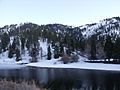
Jackson Lake
-
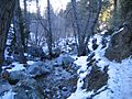
Along the Icehouse Canyon Trail
-
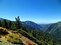
View west from Angeles Crest Highway
-
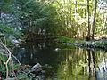
Riparian zone habitat.
-
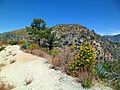
Montane chaparral ecotone with the Mojave Desert. Yellow sulphurflower buckwheat flowers in foreground.


See also
 In Spanish: Bosque nacional de Ángeles para niños
