
San Francisquito Canyon facts for kids

San Francisquito Canyon is a long, narrow valley in Los Angeles County, Southern California. It was formed by the San Francisquito Creek carving its way through the Sierra Pelona Mountains.
Contents
Where is San Francisquito Canyon?
This canyon cuts right through the Sierra Pelona Mountains. These mountains are a key part of California's Transverse Ranges system. At the very top of San Francisquito Canyon is the San Francisquito Pass. This pass was once an important route for travelers going between Los Angeles and the San Joaquin Valley. As you travel down the canyon, it gets wider as it nears the Santa Clarita Valley. The middle and upper parts of the canyon are located within the Angeles National Forest.
A Look Back: History of the Canyon

Gold Mining in the Canyon
San Francisquito Canyon was a place where people searched for gold. Spanish missionaries from the San Fernando and San Buenaventura Missions were among the first to mine here. Later, Mexican Californios also searched for gold. Their mining efforts stopped in 1848. This was when gold was discovered at Sutter's Mill, starting the famous California Gold Rush. Even after the Gold Rush, placer mining continued in the canyon until at least the late 1800s.
The St. Francis Dam Disaster
Between 1924 and 1928, a large structure called the St. Francis Dam was built in the canyon. Sadly, at 11:57 PM on March 12, 1928, the dam broke apart. A huge flood rushed down the canyon, and about 400 people lost their lives. The collapse of the St. Francis Dam is considered one of the worst engineering failures in American history during the 20th century. It remains the second-largest loss of life in California's history, after the 1906 San Francisco earthquake and fire. You can still see parts of the dam's ruins today.
Old Roads and New Paths

Since 1820, San Francisquito Canyon and the San Francisquito Pass have been part of important travel routes. They were part of the original El Camino Viejo trail. From 1854, the wagon route for the Stockton–Los Angeles Road followed this path. The Butterfield Overland Mail in California also used this route from 1858 to 1861. These routes, including the Tejon Pass Route, were the main ways to travel north and south to the San Joaquin Valley. This continued until a more direct road, the Ridge Route, was built in 1915.
Today, a two-lane road named after the canyon connects Santa Clarita to mountain towns. These towns include Green Valley and Elizabeth Lake. This road generally follows the path of the creek between San Francisquito Pass and its end in the northern Santa Clarita Valley.
Images for kids
-
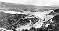
Water held in a reservoir behind the St. Francis Dam in early 1927.

