
Glendora, California facts for kids
Quick facts for kids
Glendora, California
|
|||||
|---|---|---|---|---|---|

Glendora Village with Ficus trees
|
|||||
|
|||||
| Motto(s):
Pride of the Foothills
|
|||||

Location of Glendora in Los Angeles County, California.
|
|||||

Glendora, California
Location in California

Glendora, California
Location in the United States
|
|||||
| Country | United States | ||||
| State | California | ||||
| County | Los Angeles | ||||
| Founded | April 1, 1887 | ||||
| Incorporated | November 13, 1911 | ||||
| Named for | Leadora Bennett Whitcomb | ||||
| Area | |||||
| • Total | 19.66 sq mi (50.92 km2) | ||||
| • Land | 19.51 sq mi (50.52 km2) | ||||
| • Water | 0.15 sq mi (0.40 km2) 0.84% | ||||
| Elevation | 774 ft (236 m) | ||||
| Population
(2020)
|
|||||
| • Total | 52,558 | ||||
| • Density | 2,582/sq mi (996.9/km2) | ||||
| Time zone | UTC−8 (PST) | ||||
| • Summer (DST) | UTC−7 (PDT) | ||||
| ZIP Codes |
91740 and 91741
|
||||
| Area codes | 626, 909/840|840 | ||||
| FIPS code | 06-30014 | ||||
| GNIS feature ID | 1652713 | ||||


Glendora is a city in the San Gabriel Valley of Los Angeles County. It's about 25 miles (40 km) northeast of Downtown Los Angeles. In 2020, about 52,558 people lived here. The famous Route 66 goes right through Glendora. Like many nearby cities, Glendora started during a big land boom in the 1880s.
Glendora is known as the "Pride of the Foothills." It sits in the foothills of the San Gabriel Mountains. Its downtown area, called Glendora Village, has many restaurants, cafes, shops, and boutiques. Lots of community events happen there all year.
Homes in Glendora show the city's history. You can find Queen Anne and Folk Victorian houses. There are also early 1900s bungalows and ranch-style homes. Some areas have large, private mansions with amazing views of the San Gabriel Valley and Downtown Los Angeles.
Glendora is next to Azusa and Citrus to the west. To the east and south are San Dimas. Covina and Charter Oak are to the south. To the north are the San Gabriel Mountains, including parts of the San Gabriel Mountains National Monument.
Contents
Glendora's History
Early People of Glendora
The first signs of people living in the Glendora area are from around 6000 BCE. Around 3500 BCE, the Takic people moved into this region. When Europeans first arrived in Los Angeles County, the Tongva people were the main group. They were also called the Kizh or Gabrieleños.
The Tongva people lived in villages and seasonal camps. These were usually near water sources like streams. The closest villages to modern Glendora were Asuksa-nga in Azusa and Duarte, and Momwamomutn-gna in San Dimas. The area that is now Glendora was used for seasonal camps and hunting.

Tongva daily life depended on the land. They mostly hunted and gathered food. Oak trees in the San Gabriel foothills provided acorns, a main food. Acorns were ground into flour and made into a mush. Along rivers, they gathered wild seeds, berries, and herbs. In areas like Glendora, they hunted deer, rabbits, and birds for protein.
The Tongva traded a lot with other tribes. They were one of the richest groups in Southern California. They traded items like stone bowls and shells. Their trade network reached tribes far away, showing their wide influence.
Tongva homes were dome-shaped structures called kich or kiiğa. They were made of willow branches and covered with grass. Villages had a few dozen to a hundred people. Each village had its own chief. Men hunted and fished, while women gathered food and wove baskets. They used local plants for food, medicine, and materials. The Tongva had a deep connection to the land.
When the Spanish arrived in the 1770s, about 5,000 to 10,000 Tongva people lived in the Los Angeles Basin.
Spanish Rule (1769–1821)
After Christopher Columbus arrived in the Americas in 1492, Spain and Portugal argued over new lands. The Pope divided the world, giving most of the Americas to Spain. Spain claimed California in 1542, but didn't settle it for over 200 years.
In the late 1760s, Spain worried about other European countries. They started building missions, towns (pueblos), and forts (presidios) in California. Junípero Serra led the missionaries. The Spanish also encouraged non-Spanish settlers to move to California.
The Glendora area was under the control of Mission San Gabriel Arcángel. This mission was founded in 1771. It managed local life and farming. The Tongva people were forced to work for the mission. Many Tongva people got sick from diseases brought by the Europeans. Diseases like smallpox caused their population to drop a lot.
The closest Spanish town was Los Angeles, founded in 1781. By 1821, the Tongva population in the Los Angeles Basin had fallen to about 1,500 people. This was due to diseases, changes to their way of life, and harsh conditions at the missions.
Mexican Rule (1821–1848)
Mexico became free from Spain in 1821. California was a distant area with little control from the new Mexican government. This led to informal rules and loose land boundaries.

The Mission San Gabriel Arcángel, which controlled the Glendora area, faced problems. Its large herds of cattle decreased due to poor management and theft. In 1833, the Mexican government decided to take control of mission lands. This was meant to free Indigenous people and give them land. However, very few Indigenous Californians actually received land.
With the mission's power gone, its cattle disappeared quickly. This allowed powerful families to gain large land grants called ranchos. In 1837, the Rancho San José was granted, covering parts of present-day Glendora. In 1841, Rancho El Susa was granted, covering western Glendora. Henry Dalton bought Rancho El Susa in 1844 and renamed it Rancho Azusa de Dalton. He started vineyards and farms. Central and northern Glendora remained open land for cattle.
By 1848, the Tongva population in the Los Angeles Basin had dropped even more, to about 800 people. This was due to displacement, hard labor on ranchos, and diseases.
American Rule (1848–Present)
End of the Rancho Era
After the Mexican–American War in 1848, California became part of the United States. This brought big changes for ranch owners. Spanish and Mexican land boundaries were often informal. American authorities needed exact land surveys and taxes. This caused many legal and money problems for rancheros.
The Land Act of 1851 required landowners to prove their titles in court. This was long and expensive. California also started taxing large landholdings. Many rancheros, who had land but little cash, struggled to pay. They often had to sell parts of their land.
Henry Dalton, a ranchero in the Glendora area, owned a large amount of land. He fought in court for decades to keep his property. He eventually lost almost all his land to pay debts. Dalton died in 1884 with very little money. His story shows the challenges rancheros faced during this time.
Glendora's Founding and Growth
Glendora, like many cities in the San Gabriel Valley, was built on farmland. This happened during the Southern California real estate boom of the 1880s. Land values rose quickly after the Los Angeles and San Gabriel Valley Railroad was completed in 1887. This connected the area to Los Angeles. Train ticket prices dropped, bringing many new settlers to Southern California.
George Dexter Whitcomb started Glendora in March 1887. He divided about 300 acres of land for sale. On the first day, April 1, 1887, 300 lots were sold. Whitcomb named the city "Glendora" by combining his wife's name, Leadora, with the word "glen," because his home was in a glen of the San Gabriel Mountains.
In 1907, Glendora grew more when the Pacific Electric Railway's Monrovia–Glendora Line opened. This train provided direct service to Downtown Los Angeles. Glendora officially became a city on November 13, 1911.
Glendora became a big center for citrus fruit farming in the early 1900s. In 1947, there were over 5,000 acres of orange and lemon orchards. Six packing houses processed about 78,000 tons of fruit each year.
The downtown area has been updated over the years. Old buildings like the opera house and movie theater were changed for modern uses. You can learn about the original town layout on the Downtown Glendora Historical Walk.
Glendora was once home to military academies. These are now churches or private schools. From 1960 to 1978, Clokey Productions made Gumby and Davey and Goliath in Glendora. The city celebrated this history with Gumby Fest in 2014 and 2015.
Wildfires have affected Glendora recently. The Colby Fire caused many residents to leave their homes. A concert called "Glendora Band Aid" helped raise money for those affected.
The Glendora Chamber of Commerce, started in 1903, helps local businesses.
Glendora's Geography

Glendora is in the eastern part of the San Gabriel Valley. It has the San Gabriel Mountains to the north and the South Hills to the south.
The city covers about 19.6 square miles (50.9 km²). Most of this is land, with a small amount of water.
Climate in Glendora

Glendora has a dry Mediterranean climate. This means it has hot summers and slightly cooler winters than areas closer to the coast. Most of the rain falls in winter. Hot summer temperatures and warm Santa Ana winds in the fall increase the risk of wildfires in the mountains. Recent fires include the 2009 Morris Fire and the 2015 Cabin Fire.
| Climate data for Glendora, California (1981–2010 normals) | |||||||||||||
|---|---|---|---|---|---|---|---|---|---|---|---|---|---|
| Month | Jan | Feb | Mar | Apr | May | Jun | Jul | Aug | Sep | Oct | Nov | Dec | Year |
| Mean daily maximum °F (°C) | 68 (20) |
69 (21) |
71 (22) |
76 (24) |
79 (26) |
84 (29) |
90 (32) |
92 (33) |
89 (32) |
80 (27) |
74 (23) |
68 (20) |
78 (26) |
| Mean daily minimum °F (°C) | 43 (6) |
45 (7) |
47 (8) |
49 (9) |
54 (12) |
58 (14) |
62 (17) |
62 (17) |
60 (16) |
55 (13) |
47 (8) |
42 (6) |
52 (11) |
| Average precipitation inches (mm) | 3.78 (96) |
4.76 (121) |
2.66 (68) |
1.20 (30) |
.33 (8.4) |
.09 (2.3) |
.01 (0.25) |
.03 (0.76) |
.18 (4.6) |
1.05 (27) |
1.62 (41) |
2.45 (62) |
18.16 (461) |
Glendora's Population
| Historical population | |||
|---|---|---|---|
| Census | Pop. | %± | |
| 1920 | 2,028 | — | |
| 1930 | 2,761 | 36.1% | |
| 1940 | 2,822 | 2.2% | |
| 1950 | 3,988 | 41.3% | |
| 1960 | 20,752 | 420.4% | |
| 1970 | 31,380 | 51.2% | |
| 1980 | 38,500 | 22.7% | |
| 1990 | 47,828 | 24.2% | |
| 2000 | 49,415 | 3.3% | |
| 2010 | 50,073 | 1.3% | |
| 2020 | 52,558 | 5.0% | |
| U.S. Decennial Census 1860–1870 1880–1890 1900 1910 1920 1930 1940 1950 1960 1970 1980 1990 2000 2010 2020 |
|||
Glendora first appeared as a city in the 1920 U.S. Census.
Who Lives in Glendora?
| Race / Ethnicity (NH = Non-Hispanic) | Pop 2000 | Pop 2010 | Pop 2020 | % 2000 | % 2010 | % 2020 |
|---|---|---|---|---|---|---|
| White alone (NH) | 33,564 | 28,565 | 23,384 | 67.92% | 57.05% | 44.49% |
| Black or African American alone (NH) | 704 | 834 | 1,021 | 1.42% | 1.67% | 1.94% |
| Native American or Alaska Native alone (NH) | 158 | 102 | 120 | 0.32% | 0.20% | 0.23% |
| Asian alone (NH) | 3,003 | 3,898 | 6,656 | 6.08% | 7.78% | 12.66% |
| Native Hawaiian or Pacific Islander alone (NH) | 26 | 42 | 24 | 0.05% | 0.08% | 0.05% |
| Other race alone (NH) | 88 | 106 | 274 | 0.18% | 0.21% | 0.52% |
| Mixed race or Multiracial (NH) | 1,132 | 1,178 | 2,062 | 2.29% | 2.35% | 3.92% |
| Hispanic or Latino (any race) | 10,740 | 15,348 | 19,017 | 21.73% | 30.65% | 36.18% |
| Total | 49,415 | 50,073 | 52,558 | 100.00% | 100.00% | 100.00% |
In 2020, Glendora had 52,558 people. There were 16,887 households, with about 3 people per household. The city's population density was about 2,582 people per square mile. The main racial groups were White (70.4%), Black or African American (1.9%), Native American (0.6%), Asian (11.6%), and Pacific Islander (0.3%). About 7.2% of people were from two or more races. About 34.4% of the population was Hispanic or Latino.
In 2020, the average household income in Glendora was $96,132. About 8.3% of the people lived below the poverty line.
How Glendora is Governed
City Government
Glendora became an official city on November 13, 1911. This makes it the 25th oldest city in Los Angeles County. It has a council–manager government. This means a City Manager runs the city's daily business. The City Manager is chosen and watched over by a city council of five members. The current City Manager is Adam Raymond.
Since 2020, council members are elected by district. They serve four-year terms. After each election, the council chooses a mayor and a mayor pro tem from its members. The current Mayor is David Fredendall.
Glendora changed its election system to district-based elections. This was done to avoid lawsuits under the California Voting Rights Act of 2001. The first district elections happened in March 2020.
The Glendora Police Department and the Los Angeles County Fire Department provide public safety services.
State and Federal Government
In the California State Legislature, Glendora is part of the 25th Senate District and the 48th Assembly District.
In the United States House of Representatives, Glendora is split between the 28th and 31st Congressional Districts.
Education in Glendora
Glendora has two public school districts: Glendora Unified and Charter Oak Unified School Districts (COUSD). Both are known for being excellent schools. Many schools in these districts have been named California Distinguished Schools and Gold Ribbon Schools.
Elementary Schools
- Cullen Elementary School
- La Fetra Elementary School
- Sellers Elementary School
- Stanton Elementary School
- Sutherland Elementary School
- Washington Elementary School (COUSD)
- Willow Elementary School (COUSD)
Middle Schools
- Goddard Middle School
- Sandburg Middle School
High Schools
- Glendora High School
Continuation High Schools
- Arrow Continuation High School (COUSD)
- Whitcomb Continuation High School
Private Schools
- Hope Lutheran Church and School – For preschool through 8th grade
- Foothill Christian School – For preschool through 8th grade
- St. Lucy's Priory High School – An all-girls college-prep high school
- St. Dorothy School – For kindergarten through 8th grade
Colleges and Universities
- Citrus College
Public Health
Glendora has two hospitals:
- Foothill Presbyterian Hospital
- Glendora Community Hospital
Los Angeles County also offers health services for Glendora residents at the Monrovia Health Center and Pomona Health Center.
Culture and Fun in Glendora
Cultural Places
- Haugh Performing Arts Center
- Glendora Historical Society Museum
- Rubel Castle, built by Michael Rubel
- Glendora Public Library
- Glendora Public Market
- Glendora Big Tree Park
Parks and Trails

Glendora has many parks, trails, and fun programs.
- Big Dalton Canyon Wilderness Park and Campground
- Centennial Heritage Park – This park shows what a citrus ranch looked like in the late 1800s. It has the Hamilton House and old farm tools. It also has the Orton Englehart workshop, named after the inventor of the Rain Bird sprinkler.
- Finkbiner Park
- Big Tree Park – A small park with a 140-year-old Moreton Bay Fig tree.

- Louie Pompei Memorial Sports Park
- Glendora Urban Trail System
- South Hills – A park with wilderness trails.
- Colby Trail
- Lower Monroe Truck Trail – For hiking and mountain biking.
- Punk Out Trail
- Mystic Canyon Trail
- Glendora bougainvillea – The largest growth of Bougainvillea in the United States.
- Glen Oaks Golf and Learning Center – Has a driving range and a 9-hole golf course.
- Camp Cahuilla Summer Camp ("Dirt Camp") – A popular summer camp for kids.
- San Gabriel Mountains National Monument – The headquarters are in Glendora. Several trails lead from Glendora into the park. Glendora Mountain Road is popular for mountain bikers and sightseers.
Glendora Mountain Road and Glendora Ridge Road offer great views through the San Gabriel Mountains. These roads have also been part of the international Tour of California bike race.
Getting Around Glendora
Public Transportation
Foothill Transit serves Glendora. It offers connections throughout the city and express service to Downtown Los Angeles. The Metro A Line train station at APU/Citrus College in Azusa connects to the Metro train and bus system.
A future extension of the A Line will include a station in Glendora. This station is located at Ada Avenue and Vermont Avenue. The station was dedicated on June 5, 2025. Train service is expected to begin in the summer of 2025. This extension will provide a direct ride to the Financial District of Los Angeles and downtown Long Beach.
Glendora also has its own weekday shuttle service, the Glendora Mini Bus. It connects to the Metrolink station in Covina and the APU/Citrus College Metro station. It also links some of the city's schools. The Mini Bus offers door-to-door service for seniors and disabled residents.
Freeways and Highways

Glendora is located where two major freeways meet: the 210 and the 57. These freeways connect the city to the rest of Southern California. Historic U.S. Route 66 also runs through the city from east to west. Other important roads include Foothill Boulevard, Grand Avenue, Arrow Highway, and Lone Hill Avenue.
Airports
There are no airports within Glendora. The city is within 45 miles of major airports. These include Los Angeles International Airport (LAX), Hollywood Burbank Airport (BUR), Ontario International Airport (ONT), Long Beach Airport (LGB), and John Wayne Airport (SNA).
Glendora's Economy
The National Hot Rod Association and Armstrong Garden Centers have their main offices in Glendora.
Top Employers
Here are the top employers in Glendora, based on a 2018 report:
| Rank | Employer | # of Employees |
|---|---|---|
| 1 | Citrus College | 807 |
| 2 | Glendora Unified School District | 798 |
| 3 | LA County Department of Children and Family Services | 600 |
| 4 | Foothill Presbyterian Hospital | 653 |
| 5 | Glendora Grand | 350 |
| 6 | Ormco Corporation | 350 |
| 7 | Walmart | 416 |
| 8 | Glendora Community Hospital | 334 |
| 9 | City of Glendora | 245 |
| 10 | Sam's Club | 196 |
Media in Glendora
Glendora is part of the Los Angeles media market. This means it gets TV and radio stations from Los Angeles.
Glendora is also within the "Studio Zone," or "Thirty Mile Zone" (TMZ). This area is important for filming movies and TV shows. Productions filmed here are considered "local," which saves money. Famous productions filmed in Glendora include the NBC series Heroes, MTV's Faking It, and the movie The Circle (2017).
Television
KGLN TV is a public-access channel run by the City of Glendora. It shows city meetings, city events, and information from the city.
News Media
The San Gabriel Valley Tribune provides news for Glendora and nearby communities.
Library Happenings is a newsletter from the Glendora Public Library. It shares information about library programs and events.
Glendora City News is a local news source started in 2014. It covers city news, local events, and public safety updates.
Famous People from Glendora
- Michael Anthony – Bassist for Van Halen
- LaVar Arrington – Former NFL player
- Steven Barnes – Science fiction and mystery author
- Bryan Clay – Olympic gold medalist in Decathlon (2008)
- Art Clokey – Creator of Gumby
- Rocky Dennis – Subject of the movie Mask
- Soleil Moon Frye – Actress from Punky Brewster
- Howard Hawkes – American film director
- Casey Jacobsen – Basketball player
- Tamra Judge – TV personality from The Real Housewives of Orange County
- David Klein – Inventor of Jelly Belly candy
- D. Wayne Lukas – Racehorse trainer
- Richard and Maurice McDonald – Founders of McDonald’s
- Gabrial McNair – Keyboardist for No Doubt
- José Mota – Baseball announcer
- Tracy Murray – Former basketball player
- Anna Nalick – Singer
- Vince Neil – Singer for heavy metal band Mötley Crüe
- DJ Peters – Baseball player
- Adam Plutko – Baseball player
- Sally Rand – Actress and dancer
- Tony Robbins – Motivational speaker
- Aaron Rowand – Baseball player
- Misty Rowe – Actress
- Julie Smith – Olympic softball gold medalist
- Philip Shahbaz – Voice actor
- Charles Silent – Important figure in developing Los Angeles parks
- Esther Snyder – Co-founder of In-N-Out Burger
- Lynsi Snyder – Owner of In-N-Out Burger
- Alex Solis – Jockey
- Woody Strode – Actor and football player
- The Surfaris – Surf music band
- Deontay Wilder – Former WBC World Heavyweight Boxing Champion
- Shawn Wooten – Baseball player
Sister Cities
Glendora has two sister cities:
 Mōka (真岡市), Tochigi Prefecture, Japan
Glendora and Mōka have been sister cities since 1988. For many years, students from Goddard Middle School and Sandburg Middle School have exchanged visits with students from Mōka. The flag of Mōka is displayed in Glendora's city council chambers.
In 1966, Glendora became a sister city with Mérida, the capital of Yucatán. The two cities had exchange programs for students, police officers, and firefighters. A mural in the Glendora Public Library, called “Contributions of the Mayan Culture and the Modern Man,” was a gift from Mérida in 1976. The Glendora Sister City Association was not active for a while, but it restarted in 2023. Efforts are now being made to bring back active cultural exchanges between the two cities.
See also
 In Spanish: Glendora (California) para niños
Images for kids
-
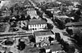
Glendora, 1920.
-
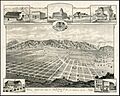
Early Alosta-Glendora Map 1888. View looking north from present-day South Hills Park Wilderness Area
-
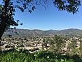
(2017) view from the South Hills


