Duarte, California facts for kids
Quick facts for kids
Duarte, California
|
|||
|---|---|---|---|

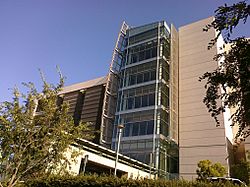
Helford Clinical Research Hospital at the City of Hope National Medical Center
|
|||
|
|||
| Motto(s):
"City of Health"
|
|||

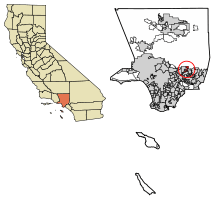
Location of Duarte in Los Angeles County, California.
|
|||
| Country | |||
| State | |||
| County | Los Angeles | ||
| Incorporated | August 22, 1957 | ||
| Named for | Andrés Duarte | ||
| Government | |||
| • Type | Council-Manager | ||
| Area | |||
| • Total | 6.71 sq mi (17.38 km2) | ||
| • Land | 6.71 sq mi (17.38 km2) | ||
| • Water | 0.00 sq mi (0.00 km2) 0% | ||
| Elevation | 512 ft (156 m) | ||
| Population
(2020)
|
|||
| • Total | 21,727 | ||
| • Density | 3,238.49/sq mi (1,250.39/km2) | ||
| Time zone | UTC-8 (Pacific) | ||
| • Summer (DST) | UTC-7 (PDT) | ||
| ZIP codes |
91008-91010
|
||
| Area code | 626 | ||
| FIPS code | 06-19990 | ||
| GNIS feature ID | 1652699 | ||
Duarte is a city in Los Angeles County, California, United States. In 2020, about 21,727 people lived there. The city is surrounded by the San Gabriel Mountains to the north. It also borders other cities like Bradbury, Monrovia, Irwindale, and Azusa.
Duarte is located along the historic U.S. Route 66. This famous road now follows Huntington Drive through the city. The city gets its name from Andrés Avelino Duarte. He was a Californian ranchero (a person who owned a large ranch). He started the community on his land grant, which was called Rancho Azusa de Duarte.
Contents
History
Around 500 B.C., a group of Shoshonean-speaking people settled in what is now the San Gabriel Valley. These Native Americans are now known as the Tongva. They ate a lot of acorns from the many oak trees in the valley. They would boil acorn flour to make a meal.
Spanish Era in Duarte
Duarte's connection to Europeans began in 1769. At that time, the king of Spain claimed all the land in California. The first Europeans visited the San Gabriel Valley during an expedition in 1769. This trip was led by Gaspar de Portolà from San Diego to Monterey Bay.
A Franciscan priest named Juan Crespí joined Portolà. He wrote detailed descriptions of their journey. Much of what we know about early California comes from his writings.
On September 8, 1771, the Franciscans built the Mission San Gabriel Arcangel in the San Gabriel Valley. This mission was a stop for travelers. It also brought many Tongva people into an agricultural way of life. After Mexico became independent in 1821, the mission lands became public property.
Mexican Era in Duarte
On May 10, 1841, the governor of Alta California, Juan Bautista Alvarado, gave a large piece of land to Andrés Avelino Duarte and his wife. This land was about 7,000 acres (28 km²) in the San Gabriel Valley. Duarte named his new property "Rancho Azusa de Duarte".
The name Azusa comes from Asuksa-gna. This means "skunk place" in the Tongva language. It was the name of a Tongva settlement near the San Gabriel River. This land grant now includes parts of several cities. These are Arcadia, Monrovia, Bradbury, Duarte, Irwindale, Azusa, and Baldwin Park. Corporal Duarte had local Native Americans help him build a small home. They also helped him plant a garden and fruit trees.
When California Became Part of the United States
After the Mexican–American War, California became part of the United States in 1848. In 1851, the U.S. government created a group to check if all the land grants from Spain and Mexico were valid.
Corporal Duarte started to have legal costs and debts. He sold parts of his Rancho to pay them off. One of the first sales was 225 acres (0.91 km²) to Michael Whistler. Whistler later sold it to Dr. Nehemiah Beardslee. Dr. Beardslee started the first school in Duarte and built the first water lines. Corporal Duarte divided the rest of his Rancho into smaller plots and sold them. He finally won his land grant case in 1878. But by then, he had already sold all of his Rancho.
Many early families came to Duarte in the mid-1800s. They came for the good climate and fertile soil. English settlers, Americans from the Midwest, Latinos, and Japanese immigrants helped Duarte grow. It became a successful farming community, especially known for growing citrus fruits. The first recorded avocado tree in California was planted in Duarte. William Chappelow, Sr. planted it in 1893 from seeds sent by the U.S. Department of Agriculture.
Modern Duarte
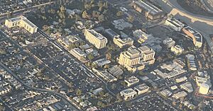
Two important medical places started in Duarte in the early 1900s. In 1913, the Jewish Consumptive Relief Association opened a place for people with tuberculosis. It started as a small tent city. This place later became the famous City of Hope National Medical Center. It is now a leader in fighting cancer and other serious diseases.
In 1930, a group of nuns called the Carmelite Sisters of the Most Sacred Heart of Los Angeles started what is now the Santa Teresita Rest Home. It used to be a full hospital. Now, it offers only outpatient services.
In 1957, some community members worked hard to make Duarte an official city. They worried that nearby cities would take over parts of Duarte. Some parts of the original Rancho had already been taken by Monrovia, Azusa, Irwindale, and Baldwin Park. At the same time, another group formed the separate city of Bradbury. Duarte became a city on August 22, 1957.
Duarte and Bradbury still have many connections. They share the same school district, post office, and ZIP code (91008). They also share public services like the Los Angeles County Sheriff's Department and Los Angeles County Fire Department.
The first city logo was made in 1957. It had a circle with an adobe arch and the Rancho Azusa de Duarte "d" brand. The current city logo was created in 1982 for Duarte's 25th anniversary.
Today, Duarte is mostly a bedroom community. This means many people who live there travel to other cities for work. Duarte is somewhat separated from other population centers. This is because of the San Gabriel River and rock quarries nearby. These factors make it hard for local businesses to attract outside spending. Most residents spend their money in other areas.
The city has tried to stop the quarries from growing. This is due to concerns about air quality and noise. However, they have not been successful. Still, city leaders have worked to bring more stores and businesses to the western part of Duarte.
Geography
Duarte is located at 34°08′25″N 117°57′42″W / 34.140416°N 117.961678°W.
The United States Census Bureau says the city covers about 6.7 square miles (17.38 km²). All of this area is land.
Population Information
| Historical population | |||
|---|---|---|---|
| Census | Pop. | %± | |
| 1960 | 13,962 | — | |
| 1970 | 14,981 | 7.3% | |
| 1980 | 16,766 | 11.9% | |
| 1990 | 20,688 | 23.4% | |
| 2000 | 21,486 | 3.9% | |
| 2010 | 21,321 | −0.8% | |
| 2020 | 21,727 | 1.9% | |
| U.S. Decennial Census | |||
Duarte's Population in 2020
The 2020 United States Census showed that Duarte had 21,727 people. This means there were about 3,187 people per square mile (1,250 per km²).
About 57.8% of the people were White, and 6.1% were African American. About 17.2% were Asian, and 6.4% were from two or more races. Nearly half, 49.9%, were Hispanic or Latino.
Most people, 63.1%, owned their homes. There were 7,132 households, with about 2.98 people per household.
About 4.5% of the population was under 5 years old. 17.6% were between 6 and 17. The largest group, 58.5%, was between 18 and 65. About 19.4% were 65 or older. More than half of the population, 54.8%, was female.
In 2020, the average household income in Duarte was $75,083. About 10.2% of the people lived below the poverty line.
Education
The Duarte Unified School District serves students from Duarte, Bradbury, and nearby areas. The district has four elementary schools: Maxwell, Beardslee, Royal Oaks, and Valley View. It also has one high school, Duarte High School. There is also a continuation high school, the Mt. Olive Institute of Technology. Since 2018, CS Arts (California School of Arts) is also part of the district.
Duarte also has five licensed private schools. Foothill Oaks Academy is a non-religious school for preschool through 7th grade. The Duarte Montessori School is for preschool through 2nd grade. The School of the Little Scholar is a non-religious preschool. ABC School is another non-religious preschool that helps children with special education needs. The Hayden Child Care Center is a Roman Catholic school for preschool and kindergarten.
Media
News about the Duarte community is provided by the San Gabriel Valley Tribune. There is also the Duarte Dispatch, a weekly newspaper published by Beacon Media News.
Notable People
- David Henry Breaux – an activist
- Bill Melton – a Major League Baseball player. He played for the Chicago White Sox, Cleveland Indians, and Los Angeles Angels. He was the 1971 American League home run champion.
- Glenn Miller – a famous big band leader, composer, and trombone player.
- Sam Shepard – a well-known playwright, writer, and actor.
- William A. Spinks – a billiards champion. He helped invent modern billiard cue chalk. He also grew plants, and the Spinks Avocado was a very popular type of avocado.
See also
 In Spanish: Duarte (California) para niños
 | Ernest Everett Just |
 | Mary Jackson |
 | Emmett Chappelle |
 | Marie Maynard Daly |


