
Azusa, California facts for kids
Quick facts for kids
Azusa, California
|
|||||
|---|---|---|---|---|---|

Azusa City Hall
|
|||||
|
|||||
| Nickname(s):
"The Canyon City"
|
|||||

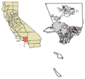
Location of Azusa in Los Angeles County, California
|
|||||

Azusa, California
Location in the Los Angeles metropolitan area

Azusa, California
Location in California

Azusa, California
Location in the United States

Azusa, California
Location in North America
|
|||||
| Country | United States | ||||
| State | California | ||||
| County | Los Angeles | ||||
| Founded | 1887 | ||||
| Incorporated | December 29, 1898 | ||||
| Incorporated | August 14, 1901 | ||||
| Named for | A hispanicized version of Asuksa-nga, the Tongva settlement that existed at the time of Spanish colonization | ||||
| Government | |||||
| • Type | Council-Manager | ||||
| Area | |||||
| • Total | 9.67 sq mi (25.05 km2) | ||||
| • Land | 9.66 sq mi (25.02 km2) | ||||
| • Water | 0.01 sq mi (0.03 km2) 0.13% | ||||
| Elevation | 610 ft (186 m) | ||||
| Population
(2020)
|
|||||
| • Total | 50,000 | ||||
| • Density | 5,175.45/sq mi (1,998.24/km2) | ||||
| Time zone | UTC−8 (Pacific) | ||||
| • Summer (DST) | UTC−7 (PDT) | ||||
| ZIP Code |
91702
|
||||
| Area code(s) | 626 | ||||
| FIPS code | 06-03386 | ||||
| GNIS feature IDs | 1652667, 2409768 | ||||


Azusa is a city in Los Angeles County, California, United States. It's located in the San Gabriel Valley, right at the base of the San Gabriel Mountains. Azusa is about 20 miles east of downtown Los Angeles.
The city's name comes from the Tongva word Azuksa, which means "skunk." In 2020, about 50,000 people lived there. Azusa is also famous for being along historic Route 66.
Azusa is surrounded by other cities and areas. To the north are the San Gabriel Mountains. Irwindale is to the west, and Glendora is to the east. Covina is to the south.
Contents
History of Azusa
How Azusa Got Its Name
The name "Azusa" comes from the Tongva people. They were the first people to live in this area. The word Asuksa-nga meant "skunk place."
For many years, people have used a fun saying to promote the city: "Azusa stands for everything from A to Z in the U.S.A."
Early Settlements and Land Ownership
People first settled in this area around 6000 BC. The Tongva people arrived much later, by at least 55 BC. They are considered the original people of the region.
The first Mexican settlement in Azusa was in 1841. It was called Rancho el Susa. This land was given by the Mexican Governor to Luis Arenas.
In 1844, Arenas sold the land to Henry Dalton. He was an English merchant from Pueblo of Los Angeles. Dalton renamed it Rancho Azusa de Dalton. He built a winery, a place to make vinegar, and a flour mill. He also planted a vineyard.
Dalton owned a lot of land in the area. This included Rancho San Francisquito and Rancho Santa Anita. This meant he owned land all the way from San Dimas to Pasadena.
Becoming a City
After California became part of the United States, Henry Dalton had to prove he owned his land. This led to many years of legal battles.
He borrowed money from a banker named Jonathan S. Slauson. In 1880, Dalton had to give his land to Slauson. Slauson then planned out the city in 1887. Azusa officially became a city in 1898.
The Los Angeles and San Gabriel Valley Railroad came to Azusa in 1887. This brought many new people looking for homes. This railroad line is now used by the A Line light rail.

Geography and Climate
The Canyon City
Azusa is located at the entrance to the San Gabriel Canyon. This is why the city is often called "The Canyon City." It sits on the east side of the San Gabriel River.
The city covers about 9.7 square miles (25.05 square kilometers). Almost all of this area is land.
Azusa's Weather
Azusa has a warm-summer Mediterranean climate. This means it has warm, dry summers. The average monthly temperatures are usually below 71.6°F (22°C).
Population and People
How Many People Live Here?
| Historical population | |||
|---|---|---|---|
| Census | Pop. | %± | |
| 1860 | 363 | — | |
| 1870 | 320 | −11.8% | |
| 1900 | 863 | — | |
| 1910 | 1,477 | 71.1% | |
| 1920 | 2,460 | 66.6% | |
| 1930 | 4,808 | 95.4% | |
| 1940 | 5,209 | 8.3% | |
| 1950 | 11,042 | 112.0% | |
| 1960 | 20,497 | 85.6% | |
| 1970 | 25,217 | 23.0% | |
| 1980 | 29,380 | 16.5% | |
| 1990 | 41,333 | 40.7% | |
| 2000 | 44,712 | 8.2% | |
| 2010 | 46,361 | 3.7% | |
| 2020 | 50,000 | 7.8% | |
| U.S. Decennial Census 1860–1870 1880-1890 1900 1910 1920 1930 1940 1950 1960 1970 1980 1990 2000 2010 2020 |
|||
Azusa first appeared as a city in the 1860 U.S. Census. In 2020, the population of Azusa was 50,000 people. This was an increase from 46,361 people in 2010.
Who Lives in Azusa?
Azusa is a diverse city. In 2020, about 64% of the population was Hispanic or Latino. Other groups include White (15.5%), Asian (14.37%), and Black or African American (3.18%).
In 2010, about 26.8% of the people were under 18 years old. The median age was 29.3 years. This means half the population was younger than 29.3 and half was older.
Most people in Azusa live in households. In 2010, there were 12,716 households. The average household had about 3.43 people.
Economy and Jobs
Top Employers
Azusa has many different businesses. Here are some of the biggest employers in the city:
| # | Employer | # of Employees |
|---|---|---|
| 1 | Azusa Pacific University | 1,433 |
| 2 | Azusa Unified School District | 1,250 |
| 3 | Northrop Grumman | 859 |
| 4 | City of Azusa | 383 |
| 5 | Costco Wholesale Corporation | 295 |
| 6 | S&S Foods LLC | 285 |
| 7 | Hanson Distributing Company | 195 |
| 8 | Buena Vista Food Products | 186 |
| 9 | Target Corporation | 142 |
| 10 | Artisian Screen | 140 |
Past Industries
Azusa was once home to a large brewery. It was first the Lucky Lager brewery, then General Brewing, and later Miller Brewery. The facility closed in 1980.
A company called Aerojet used to make rocket engines in Azusa. After they stopped operating, it was found that some chemicals had affected the groundwater (water underground). The company worked with the government to clean up the water. This is important because the groundwater provides much of the city's drinking water.
Education in Azusa
Public Schools
The Azusa Unified School District serves the city's public schools.
- Seven elementary schools: Dalton, Hodge, Lee, Magnolia, Murray, Paramount, and Valleydale.
- One Kindergarten-only school: Longfellow.
- Gladstone Middle School.
- Azusa High School.
- Sierra (Continuation) High School.
- Azusa Adult School.
Private Schools and Universities
- St. Frances of Rome Elementary School (grades K–8).
- Azusa Pacific University is a private Christian university.
- Dhammakaya Open University is a private Buddhist university.
Transportation Around Azusa
Major Roads
The Foothill Freeway (I-210) runs through Azusa. Other important roads include Azusa Avenue (SR 39). This road goes from the Angeles National Forest all the way south to Orange County.
Foothill Boulevard is another main street. A part of it was once historic U.S. Route 66.
Public Transportation
Azusa is a major stop for the Los Angeles Metro Rail A line. This is a light rail train that connects Azusa to Union Station in Los Angeles. The A Line stops at Azusa Downtown station and APU/Citrus College station.
The A Line was extended to Azusa in 2016. There are plans to extend the line even further east in the future. The Metrolink train also has nearby stops in Covina and Baldwin Park.
Healthcare
The Los Angeles County Department of Health Services helps provide healthcare for Azusa residents. They operate the Monrovia Health Center in Monrovia.
Sister City
Azusa has one sister city. This means they have a special friendship and cultural exchange with another city.
- Zacatecas, in the State of Zacatecas, Mexico.
Famous People from Azusa
Many notable people have connections to Azusa:
- Hank Aguirre, a professional baseball pitcher.
- Adore Delano, a TV personality and singer.
- Billy Kilmer, an NFL quarterback.
- Shinya Kimura, a motorcycle builder.
- Zack Padilla, a world champion boxer.
- Anthony Robbins, a life coach and author.
- Lizette Salas, a professional golfer.
- Tatiana Suarez, a mixed martial artist.
- Ruth Wysocki, a track athlete and U.S. champion.
- Members of Silent Planet, a metalcore band.
- Scheana Shay, a television personality and singer.
Images for kids
-
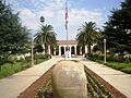
Azusa City Hall
-
Flag of Azusa, California
-
City seal of Azusa, California
-
Logo of Azusa, California
-
Location of Azusa in Los Angeles County, California
See also
 In Spanish: Azusa (California) para niños
