U.S. Route 66 in California facts for kids
Quick facts for kids
U.S. Route 66 |
||||
|---|---|---|---|---|
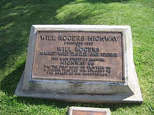
| Will Rogers Highway | ||||
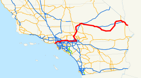
One of the former routings of Route 66 in California.
|
||||
| Route information | ||||
| Maintained by CDOH | ||||
| Length | 316 mi (509 km) | |||
| Existed | November 11, 1926–June 25, 1979 | |||
| Tourist routes |
||||
| Major junctions | ||||
| West end | ||||
|
||||
| East end | ||||
| Location | ||||
| Counties: | Los Angeles, San Bernardino | |||
| Highway system | ||||
| United States Numbered Highways List • Bannered • Divided • Replaced State highways in California(list • pre-1964)
|
||||
U.S. Route 66 (also called US 66 or just Route 66) was a very famous road in the United States. In California, it stretched from the sunny beaches of Santa Monica on the Pacific Ocean. It then went through big cities like Los Angeles and San Bernardino. Finally, it reached Needles at the border with Arizona.
Route 66 was officially removed in 1979. Today, parts of it are still used as local streets. Other parts have become new highways like State Route 2 and Interstate 40.
Contents
The Story of Route 66
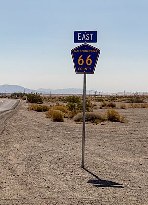
Route 66 was first marked on maps in November 1926. Signs for the road went up in 1928. Even today, you can still find old and new Route 66 signs. The part of Route 66 east of Pasadena kept its signs until 1974. After that, it became known as SR 66.
Across the whole country, Route 66 stopped being an official highway in 1985. The very last part of it, near Williams, Arizona, was replaced by I-40 in 1984.
People soon wanted to bring the famous road back. In 1987, a group in Arizona started calling it "Historic Route 66." This idea quickly spread to all eight states that Route 66 passed through, including California.
The California Historic Route 66 Association was formed in 1990. Their goal is to protect and promote the historic parts of Route 66 in California. They are the newest of the groups dedicated to Route 66.
The parts of historic Route 66 in Los Angeles are still busy streets. They are some of the most used parts of the old highway. However, because of all the traffic, many Route 66 fans prefer to drive on other sections. Modern travel guides often suggest taking Interstate 10 to avoid the busy city parts.
In 2018, a special bike path called U.S. Bicycle Route 66 was created. It follows parts of the historic Route 66 in California and other states.
A section of Route 66 in San Bernardino County is currently closed. This is because of important bridge repairs.
Old Trails Highway
| Location: | Main route: Los Angeles–Topock, AZ San Francisco, CA branch: San Francisco–Barstow |
|---|---|
| Existed: | 1914–present |
From San Bernardino to the Arizona border, Route 66 followed an even older road. This road was called the National Old Trails Highway. This old highway goes away from I-15 between Victorville and Barstow. It follows the railroad through towns like Oro Grande and Helendale. In Barstow, it is known as Main Street.
East of Barstow, the old highway goes through a Marine Corps base. This means people cannot always drive on it. So, traffic has to use I-40 instead. From Daggett, Historic 66 leaves I-40. It crosses I-40 three times before winding through Bagdad, Amboy, and Essex. By 1935, all of Route 66 in California was paved.
This area is a desert. Towns like Amboy started as stops for the Atlantic and Pacific Railroad. They grew bigger because of all the cars on Route 66. But when I-40 was built and went around them, these towns became ghost towns. From Essex, the highway was called Goffs Road. It went through Goffs until about 1931. The original highway winds around I-40 near Needles. Then it crosses the Colorado River into Arizona.
Exploring the Route
From Santa Monica to San Bernardino
Route 66 originally started in downtown Los Angeles. But in 1935, it was extended all the way to Santa Monica. In Santa Monica, Route 66 began at Lincoln and Olympic Boulevard. It went north on Lincoln, then turned east onto Santa Monica Boulevard. This part of the road is now called SR 2.
The route then followed Santa Monica Boulevard to its end. It continued southeast as Sunset Boulevard. This led to the Arroyo Seco (110) Parkway. Before the Arroyo Seco Parkway opened, Route 66 took a different path. It went north on Broadway, then Mission Avenue, and then Fair Oaks Avenue.
From Pasadena, the highway continued east on Colorado Boulevard. In Arcadia, Colorado Boulevard changes names. It becomes Colorado Street, then Colorado Place. The highway then continues as Huntington Drive through Arcadia, Monrovia, and Duarte. After crossing the San Gabriel River, it becomes Foothill Boulevard.
In Azusa, the highway leaves Foothill Boulevard and becomes Alosta Avenue. The city of Glendora even renamed its part of Alosta Avenue to Route 66. The road becomes Foothill Boulevard again when it enters San Dimas.
Foothill Boulevard is now called SR 66 from La Verne into San Bernardino. In San Bernardino, it becomes Fifth Street. SR 66 ends at the I-215 interchange in San Bernardino.
Desert Adventures: San Bernardino to Arizona
Route 66 originally left San Bernardino on Mount Vernon Avenue and Cajon Boulevard. These roads wound their way up to Cajon Pass. Route 66 then followed 7th Street and D Street through Victorville. After that, it used the National Old Trails Highway through Barstow, California (where it was called "Main Street"). It then crossed the Mojave Desert to Needles.
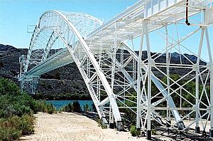
In Needles, Route 66 followed Broadway Street. It then crossed into Arizona on the Trails Arch Bridge (built in 1916). Later, in 1946, it used the Red Rock Bridge, which was once a railroad bridge.
By 1964, much of this part of Route 66 was replaced by new Interstate highways. First, it followed I-215 (which was called I-15 in 1964). After I-15, the highway followed I-40 all the way to the Arizona state line in Needles.
Famous Spots Along the Way
Cool Places to See
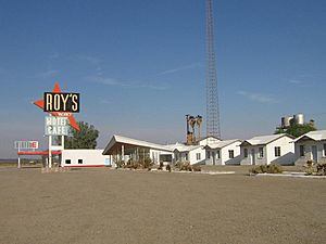
Roy's Motel and Café was once a very big business in the desert ghost town of Amboy, California. The motel closed when Interstate 40 in California took traffic away from the town. Amboy has been used as a place to film movies. More recently, the gas station and cafe at Roy's have opened sometimes. This helps keep this famous place alive for tourists.
The Summit Inn was a diner and gas station. It first opened in 1928 at the top of the Cajon Pass. In 1952, the road changed, so the Inn moved to Oak Hills, California. Famous people like Elvis Presley visited it. The building was sadly destroyed by a fire in 2016. The owners plan to rebuild it to look just like it did before the fire.
Unique Buildings
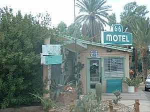
Route 66 has always been popular with travelers looking for places to stay. During the Great Depression, many people camped along the road. The book The Grapes of Wrath describes a simple campground in Needles, California. Needles was also home to Carty's Camp cabins, seen in the 1940 movie The Grapes of Wrath. Nearby is the 66 Motel, which now offers long-term stays.
The 1924 Aztec Hotel in Monrovia is a special building. It is a National Historic Landmark because of its unique Mayan Revival style.
One of three restored Wigwam Motels is in San Bernardino. These motels have cabins shaped like concrete wigwams. They were a big inspiration for the Cozy Cone Motel in the movie Cars (film).
Route 66 Museums
California has two museums dedicated to the history of old Route 66. The California Route 66 Museum is in Victorville. It is located in what used to be the Red Rooster Café. The other museum is the Barstow Route 66 "Mother Road" Museum in Barstow. It is in the town's old Harvey House Railroad Depot.
Bridges and Tunnels
The Figueroa Street Tunnels carry the Arroyo Seco Parkway through Elysian Park in Los Angeles. A special road connection called the Four Level Interchange was built here. It was the first "stack interchange" in the world. It connects the Hollywood Freeway (Route 101) to Route 66.
The historic 1916 Trails Arch Bridge crosses the Colorado River. It connects Topock, Arizona to Needles, California. The bridge is still standing, but cars can no longer drive on it. The road part was removed to make way for a natural gas pipeline.
See also
- U.S. Route 80 in California
- List of landmarks on U.S. Route 66
|
 | Jessica Watkins |
 | Robert Henry Lawrence Jr. |
 | Mae Jemison |
 | Sian Proctor |
 | Guion Bluford |


