
U.S. Route 395 in California facts for kids
Quick facts for kids
|
||||
|---|---|---|---|---|
|
US 395 highlighted in red
|
||||
| Route information | ||||
| Defined by S&HC § 610 | ||||
| Maintained by Caltrans | ||||
| Length | 556.909 mi (896.258 km) | |||
| Existed | 1930s–present | |||
| Tourist routes |
||||
| Southern segment | ||||
| South end | ||||
| Major junctions |
|
|||
| North end | ||||
| Northern segment | ||||
| South end | ||||
| Major junctions |
|
|||
| North end | ||||
| Location | ||||
| Counties: | San Bernardino, Kern, Inyo, Mono; Sierra, Lassen, Modoc | |||
| Highway system | ||||
| United States Numbered Highways List • Bannered • Divided • Replaced State highways in California(list • pre-1964)
|
||||
.svg)
U.S. Route 395 (US 395) is a major highway in the United States. It stretches all the way from Hesperia, California to the Canadian border in Washington. The part of US 395 in California is about 557 miles (896 km) long. It goes from Interstate 15 (I-15) in Hesperia, north to the Oregon state line. This is near Goose Lake in Modoc County.
The highway briefly goes into Nevada. There, it serves cities like Carson City and Reno. Then it comes back into California. In the past, US 395 used to go through big cities like San Diego, Riverside, and San Bernardino.
Today, this highway helps people from the Los Angeles area reach places like the Owens Valley, Mammoth Lakes, and Mono Lake. It also provides access to Mount Whitney, the highest point in the lower 48 states. You can also reach Death Valley, the lowest point in North America, from this road.
People have used this route since the California Gold Rush. Before it had a number, it was known by names like El Camino Sierra.
Contents
Exploring US 395 in California

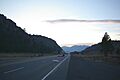
The California part of US 395 is divided into two sections. This is because the highway leaves California and then comes back in through Nevada. The southern section crosses the Mojave Desert and Owens Valley. It runs east of the Sierra Nevada mountains. The northern section also follows the Sierra Nevada and crosses the Modoc Plateau.
US 395 is an important road. It is part of the California Freeway and Expressway System. It is also part of the National Highway System. This system includes highways that are key for the country's economy and travel. Some parts of US 395 are even officially called "scenic highways." This means they pass through beautiful landscapes with few visual distractions.
Through the Mojave Desert
US 395 starts in Hesperia. It begins at an interchange with I-15 and heads north. The road then goes into Adelanto, which is on the edge of Victorville. Victorville grew quickly because of the Mojave River and a former air force base. US 395 used to be a quiet country road here. But now, as cities grow, it's becoming more like a suburban highway.

After Victorville, the scenery changes. Suburban areas disappear, and the highway goes through the Mojave Desert. It passes by a corner of Edwards Air Force Base. Then, it meets State Route 58 (SR 58) at Kramer Junction. This used to be a simple crossroad. Now, SR 58 has a new freeway path.
After Kramer Junction, US 395 passes a large solar power plant. It then crosses the Rand and El Paso Mountains. Here, the highway enters Kern County from San Bernardino County. It passes near Johannesburg. The road also crosses an old railroad line. This line used to follow SR 14 through the Mojave. US 395 follows this old railroad path all the way to Lone Pine.
On the other side of the mountains is Indian Wells Valley. US 395 goes between Ridgecrest and Inyokern. Here, a business route of US 395 goes through Ridgecrest. US 395 runs along the western edge of the Naval Air Weapons Station China Lake. This area is famous for ancient rock art made by the Coso People. The highway then joins with SR 14. Before 1964, this part of SR 14 was actually part of US 6.

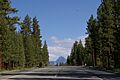
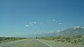
Between Mojave and US 395, SR 14 follows the edge of the Sierra Nevada mountains. US 395 then follows the valleys along the eastern side of the Sierra Nevada. The mountains get taller and taller, reaching over 14,000 feet (4,300 m) near Lone Pine. After passing three small lakes, the highway enters the Owens Valley.
The Owens Valley Journey
US 395 travels through the entire Owens Valley. It enters the valley near where the Owens Lake used to be. This valley was once home to the Timbisha and Paiute peoples. The Owens Lake and the southern part of the valley are now dry. This is because water from the valley is sent to Los Angeles through the Los Angeles Aqueduct. This happened during what are called the California Water Wars.
Along the old shores of Owens Lake, the highway passes Cartago and Olancha. Just north of the lake is Lone Pine. Lone Pine is a gateway to both Mount Whitney, the highest point in the lower 48 states, and Badwater Basin in Death Valley, the lowest point in North America. You can see both Mount Whitney and the mountains around Death Valley from US 395.
From Lone Pine to Bishop, US 395 follows an old railroad line, the Carson and Colorado Railway. This area is also known for many natural hot springs.
Past Lone Pine, the highway passes the Manzanar National Historic Site. This was a camp where Japanese Americans were held during World War II. The next town is Independence, the main town of Inyo County. It is home to the Eastern California Museum. North of Independence is the Fort Independence Indian Reservation and the Tinemaha Reservoir. This is also where the Los Angeles Aqueduct gets water from the Owens River. North of this point, you will see more green plants.

In this part of the valley are Big Pine and the Big Pine Indian Reservation. From Big Pine to Bishop, US 395 shares its path with SR 168.
At the north end of the valley is Bishop. This is the largest city in the Owens Valley. Bishop is a starting point for exploring the Sierra Nevada mountains, including Mammoth Mountain. At the north end of Bishop, US 395 meets US 6. US 6 is a very long road that goes all the way across the US to Provincetown, Massachusetts.
The scenery changes a lot after Bishop. The highway climbs over 3,000 feet (910 m) in elevation. From here to Gardnerville, the highway goes over smaller mountain ranges of the Sierra Nevada.
Climbing the Sierra Nevada

US 395 climbs the Sierra Nevada mountains. It goes along a ridge between the Owens River and Rock Creek canyons. Sherwin Summit, at 7,000 feet (2,100 m), is the first of five mountain passes on US 395 in the Sierra Nevada. The highway enters Mono County halfway up this climb, which is called the Sherwin Grade.
After Sherwin Summit, the highway travels along the west side of Crowley Lake. This lake is a reservoir for the Los Angeles aqueduct. However, US 395 does not continue to follow the river. Instead, it crosses the Long Valley Caldera. This area serves ski resorts like Mammoth Lakes and Mammoth Mountain. You can reach them using SR 203.

About 8 miles (13 km) past the Mammoth Lakes turn-off, the highway reaches its second summit, Deadman Summit, at 8,036 feet (2,449 m). This summit separates the Owens River area from Mono Lake. Mono Lake is a salt lake that is about three times saltier than the ocean.
As the highway goes down towards Mono Lake, it passes near June Lake. This is a recreation area with several freshwater lakes known for trout fishing. It also has the June Mountain Ski Area. You can get to the June Lake area from US 395 using the June Lake Loop Road (SR 158).
Just before Mono Lake, US 395 briefly shares its path with SR 120. The two roads split at the south end of Lee Vining. From this point, US 395 is about 12 miles (19 km) from Tioga Pass. Tioga Pass, on SR 120, is the highest paved road in California. It is also the eastern entrance to Yosemite National Park.

The highway finally passes Mono Lake, squeezed between the lake and the Sierra mountains. The next important spot is Conway Summit. At 8,138 feet (2,480 m) high, this is the highest point on US 395 in California. It is also the highest point on any U.S. Highway in California. This summit separates the Mono Lake area from the East Walker River.
The highway goes down from Conway Summit, following small streams that lead to the East Walker River. It heads towards Bridgeport and Bridgeport Reservoir. Along the way, the highway passes by Bodie. Bodie is a ghost town that the state park system has kept just as it was, with items still on the shelves in the old stores.
The fourth summit US 395 crosses in California is Devil's Gate Pass, at 7,519 feet (2,292 m). This pass separates the East and West Walker Rivers. The road winds down from Devil's Gate, following the West Walker River. It exits near the towns of Walker and Coleville in the Antelope Valley. This is a few miles south of Topaz Lake, which is on the California-Nevada state line.
Into Nevada and Back
Topaz Lake is where US 395 leaves California. It goes into Nevada to serve the Reno and Carson City areas. The highway runs for about 87 miles (140 km) in Nevada. While in Nevada, it crosses one more pass, Simee Dimeh Summit, before leaving the mountains. The highway then returns to follow the edge of the Sierra mountains.
Around Honey Lake and the Modoc Plateau
US 395 comes back into California as a freeway. But it soon becomes a divided highway just past the state line. The road follows Long Valley Creek along the edge of the Sierra towards Honey Lake. From this point north, the highway follows a railroad line. This line was originally built by the Nevada–California–Oregon Railway. Now, the Union Pacific Railroad owns it.

The highway enters Sierra County in a corner. It then enters Lassen County just 3 miles (4.8 km) later. A short part in Lassen County is a freeway. It has one exit for SR 70 at Hallelujah Junction. This exit is numbered 8, even though it's far from the start of the highway. The number comes from the distance from where the highway re-enters California. SR 70 is known as a road that stays open in winter. Less than 5 miles (8.0 km) from Hallelujah Junction is Beckwourth Pass. This is the lowest pass in the Sierra mountains.
The highway goes towards and around the west side of Honey Lake, which is 73 square miles (190 km2) big. Then it heads to Susanville. US 395 does not actually go into Susanville. It makes a sharp turn around the Susanville Municipal Airport to avoid the city. This happens at a T-intersection with SR 36.

North of Susanville, the highway goes around Shaffer Mountain and crosses the Modoc Plateau. Along the way, it serves towns like Ravendale, Termo, and Madeline in Lassen County. It also passes Likely in Modoc County. Here, US 395 runs next to the South Fork of the Pit River. It follows it until it meets the north fork in Alturas.
After that, the highway follows the North Fork Pit River across Modoc County towards Goose Lake. The last major road it meets in California is SR 299 in Alturas. SR 299 can take you west to US 101 in Arcata. It can also take you east to the Nevada state line. The two highways briefly run together from Alturas to the XL Ranch Indian Reservation. US 395 travels north-northeast for its last 50 miles (80 km) in California. It runs next to the east shore of Goose Lake before crossing into Oregon at New Pine Creek, Oregon.
History of US 395
The Camino Sierra Trail
The Camino Sierra was an old trail from Los Angeles to Lake Tahoe. It generally followed the path of today's State Route 14, US 395, and State Route 89. People believe Jedediah Smith first used this trail in 1826. The trail became popular for gold prospectors during the California Gold Rush and the Comstock Lode. Even though this area didn't have much gold or silver, the Owens Valley was good for farming. Farmers and ranchers raised animals and grew food to trade with the mining towns nearby. The town of Bishop was started to trade with the mining town of Aurora. By 1860, the Camino Sierra was a well-known trail on maps.
After the gold rushes ended, the Camino Sierra became important again. This was because of the Los Angeles Aqueduct being built starting in 1908. The Southern Pacific Railroad even promoted the route for its beautiful views as early as 1912. By 1918, the Camino Sierra was included in the Automobile Blue Book, an early map book of the United States.
Old Railroad Lines
Both the northern and southern parts of the US 395 path were used by railroads built in the 1880s. These railroads branched off from the First Transcontinental Railroad in Nevada. Both lines were meant to connect the main Southern Pacific Railroad line in Nevada with other lines, but they were never fully completed.

On May 20, 1880, the Carson and Colorado Railway was started. Its goal was to extend a rail line from Hawthorne, Nevada through the Owens Valley towards the Colorado River. The railroad was never finished, but it did help the valley's economy grow. This line was bought by the Southern Pacific Railroad in 1900. There were plans to connect this narrow-gauge line with SP's regular lines, but it never happened. The narrow-gauge line was taken apart in 1959.
The northern part of the US 395 path was first used by the Nevada–California–Oregon Railway. This line also started in 1880, in Reno. It was meant to connect with the Great Northern Railway in Oregon. This line was also never completed, ending at Lakeview, Oregon. Part of this line is still used today. The Union Pacific Railroad now owns it. The part from Reno to Hallelujah Junction connects the Union Pacific's two main lines in northern California/Nevada.
How US 395 Got Its Name

When US 395 was first created in 1926, it was a small road connecting Spokane, Washington with Canada. In the 1930s, US 395 was extended from Spokane all the way to San Diego. It followed the Camino Sierra and used several existing state roads. This extension first appeared on maps in Nevada in 1935 and in California in 1936. By 1937, US 6 was also extended to California. It shared the same path as US 395 between Bishop and Inyokern.
The new southern end of US 395 was in San Diego. It followed much of what is now SR 163 and I-15. Over the years, parts of the road were changed. Some parts of Pomerado Road today are even signed "Historic US 395." In 1969, the part of US 395 south of Hesperia was removed and given to other roads.
Over time, the road was paved, improved, and straightened. Some parts are now built like freeways. For example, a bridge along what used to be US 395 (now I-15) was built in 1949 and replaced in 1964.
Images for kids
-
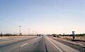
US 395 in the Mojave Desert near Victorville
-
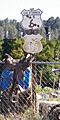
Old signs near Inyokern
-
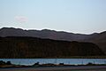
Volcanic rock above Little Lake, as seen from US 395
-
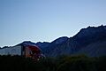
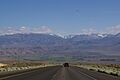
Truck passing through Owens Valley with the Sierra Nevada in the background
-
US 395 descending into Owens Valley from the Sierra Nevada, just north of Bishop
-
Southbound US 395 cresting Deadman Summit with Mount Morrison in the distance
-
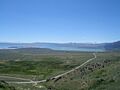
View of US 395 and Mono Lake from Conway Summit
-
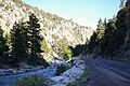
US 395 ascending the West Walker River towards Devil's Gate Pass
-
Devil's Gate Pass
-
Dedicatory road sign along US 395 just north of Mono Lake
-
US 395 between Big Pine and Independence
See also
 In Spanish: U.S. Route 395 (California) para niños
