Pit River facts for kids
Quick facts for kids Pit River |
|
|---|---|
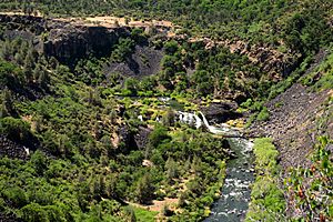
Waterfalls on the Pit River near Fall River Mills
|
|
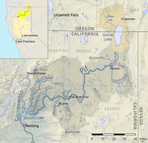
Map of the Pit River drainage basin, with the historically connected Goose Lake drainage basin indicated in orange.
|
|
| Country | United States |
| State | California |
| District | Modoc, Lassen, & Shasta counties |
| Physical characteristics | |
| Main source | Confluence of North and South Forks Near Alturas, Modoc County 4,350 ft (1,330 m) 41°28′23″N 120°33′28″W / 41.47306°N 120.55778°W |
| River mouth | Sacramento River Shasta Lake, Shasta County 1,066 ft (325 m) 40°45′23″N 122°22′14″W / 40.75639°N 122.37056°W |
| Length | 207 mi (333 km) |
| Basin features | |
| Basin size | 7,064 sq mi (18,300 km2) |
| Tributaries |
|
The Pit River is a big river in northeastern California. It flows into the state's Central Valley. The Pit River is special because it's one of only three rivers in the U.S. that crosses the Cascade Range mountains. The other two are the Klamath and the Columbia.
This river is the longest branch of the Sacramento River. It provides a lot of water, sometimes up to 80 percent, to the Shasta Lake reservoir. The main part of the Pit River is about 207 miles (333 km) (333 km) long. Some water in the system travels even further, about 265 miles (426 km) (426 km), from its farthest source to the Sacramento River.
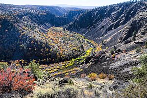
The Pit River flows through a volcanic area with few people in Modoc County. It then goes through a deep canyon in the southern Cascade Range, northeast of Redding. The river got its name from the Achomawi people, who dug pits to trap animals that came to drink from the river.
Today, the Pit River is a popular place for fishing, especially fly fishing. People also enjoy rafting in its lower parts. The river is very important for making hydroelectricity (power from water). It also helps with irrigation for farms and protecting nature.
Contents
Where the Pit River Flows
The Pit River starts with several branches in the northeastern part of California. These branches are in Modoc, Lassen, and Shasta counties. The South Fork Pit River is about 58-mile (93 km) long. It begins in the Warner Mountains and flows west through a narrow canyon. Then it goes north through a wide valley where its water is used for farming and helping birds.
The North Fork is about 30-mile (48 km) long. It starts near Goose Lake. This fork flows south and joins the South Fork near Alturas. Even though Goose Lake usually doesn't flow into other rivers, it can overflow into the Pit River during big floods. However, this hasn't happened since 1881 because so much water is used for farming.
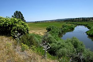
The combined river then flows west through Modoc County. It passes through the Modoc National Forest in a narrow gorge. It turns south into northern Lassen County and then into a farming area called Big Valley. The river then enters northeast Shasta County.
In Fall River Valley, the Pit River meets the Fall River. The Fall River is fed by one of the largest freshwater spring systems in the U.S. After passing Fall River Mills, the Pit River goes over Pit River Falls. Then it enters a long, winding canyon that cuts through the southern Cascade Range.
Finally, the Pit River turns south and joins the Sacramento River. This meeting point is now part of the Shasta Lake reservoir, about 15 miles (24 km) north of Redding. Two other important streams, Squaw Creek and the McCloud River, also join the Pit River within Shasta Lake. The last 30 miles (48 km) of the Pit River forms the longest arm of Shasta Lake.
How the River Gets its Water
The Pit River gets a lot of its water from underground volcanic areas. These areas create huge freshwater spring systems. This means the middle and lower parts of the Pit River have a strong flow all year round. This is different from most rivers in northern California, which change a lot with the seasons.
Before Shasta Dam was built, the Pit River provided up to 85 percent of the Sacramento River's water during the dry season. This made the Pit River very important for farming and later for making electricity. The upper parts of the Pit River, above Fall River Mills, are fed by snowmelt. These parts have a flow that changes more with the seasons.
The U.S. Geological Survey (USGS) measures the river's flow at Montgomery Creek. This spot is below Pit 7 Dam and above Shasta Lake. The average flow between 1966 and 2012 was about 4,786 cu ft/s (135.5 m3/s). The highest flow recorded was 73,000 cu ft/s (2,100 m3/s) in 1970 after heavy rain.
Dams and Power on the Pit River
The lower part of the Pit River is very important for making hydroelectric power in California. This is because it has a steady flow of water and a steep drop. In just 50 miles (80 km) between Fall River Mills and Shasta Lake, the Pit River drops about 2,200 feet (670 m). This is a big drop for a river its size. Because the water flow is so reliable, large reservoirs aren't always needed to control the water for power.
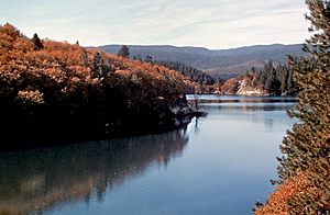
The first dam on the main Pit River is Pit 3 Dam. It creates Lake Britton near Burney. Water from Lake Britton is sent through a long tunnel to the Pit 3 Powerhouse. This powerhouse is located at the top of Pit 4 Reservoir, which is formed by Pit 4 Dam. Pit 4 is a smaller dam that sends water through another tunnel to the Pit 4 Powerhouse.
Next is Pit 5, also a small dam. From here, water goes to a special reservoir and then through a tunnel. This tunnel bypasses a bend in the Pit River and feeds the Pit 5 Powerhouse. These dams and powerhouses are managed by Pacific Gas and Electric Company (PG&E).
Below Pit 5 Powerhouse are two larger dams, Pit 6 and Pit 7. These dams release water directly from their bases to make power. Water for these dams also comes from the McCloud River, which is a branch of the Pit River. Water from the McCloud River is sent through tunnels to the James B. Black Powerhouse, which then releases it into the Pit River. These facilities are also run by PG&E.
The lowest 30 miles (48 km) of the Pit River are now part of Shasta Lake. This lake was created by Shasta Dam on the Sacramento River in 1945. Shasta Dam is a key part of the U.S. Bureau of Reclamation's Central Valley Project. This project provides a lot of water for farming in the Central Valley.
There are also power plants on the Pit River's smaller branches, like the Fall River and Hat Creek. In the past, up to 95 percent of the Pit River's summer water was used for power. This left some parts of the river almost dry. Now, rules require PG&E to keep a certain amount of water flowing in the river. This has helped wildlife and improved fishing.
History of the Pit River
Native American History
The Pit River is in the traditional land of the Achomawi people. They lived in this area for a very long time, possibly as far back as 12,500 years ago. The Achomawi people had many villages along the Pit River. They were known for digging pitfall traps to catch animals that came to the river for water. This is how the Pit River got its name. The name Achomawi means "people of the river."
The Achomawi and other local tribes mostly lived by hunting and fishing. They would move between hunting camps in the summer and live in larger wood-frame houses in the winter. The Achomawi shared borders with other tribes like the Klamath and Modoc to the north. These tribes sometimes had conflicts and disputes.
Settlers and the River
In the 1800s, many European-American settlers and traders came to the Pit River region. This happened especially after the California Gold Rush in 1848. At first, there wasn't much conflict with people just passing through. However, when white Americans started to settle near Fall River, problems began.
There were military expeditions against the local Native American tribes in the 1850s. The U.S. government decided to move the Pit River natives to reservations. The Modocs and Klamaths were also moved out of the area by 1873. After this, more settlers came to the Pit River valley.
Water Use and Power Development
The Pit River basin has a dry climate and rocky land, which made it hard for people to settle and develop the area. Ranching became the main way people made a living. In the early 1900s, many small reservoirs were built on streams that flow into the Pit River. These helped with irrigation for farms.
The Pit River was seen as the most important water source for the upper Sacramento River system. It provided most of the water, especially during the dry summer months. In the early 1900s, plans were made to build dams on the Pit River to use its water for irrigation and to make electricity.
One of the first big hydroelectric projects was the Hat Creek project, built in 1920. Pit 3 Dam (Lake Britton) was finished in 1925. Later, Pit 4 and 5 dams were built. In the 1960s, the lower Pit River was dammed, creating Reservoirs 6 and 7. Water from the McCloud River was also redirected to increase the flow through these powerhouses.
Fun Things to Do on the Pit River
The Pit River is a famous place for fishing in northern California, especially for trout. The river is known for its fast, deep water and can be tricky to wade in. The water flow is pretty steady all year, thanks to the natural springs and the many hydroelectric dams. Fishing has gotten even better since 2011. New rules made power companies keep more water flowing in parts of the river that used to be dry. This has greatly improved the places where fish live. The lower Pit River is considered a "Blue Ribbon fishery," which means it's a top-quality fishing spot.
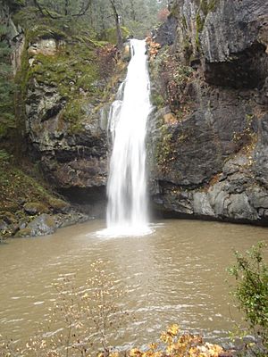
The river is also a great place for hiking and seeing beautiful sights. Many people visit to see waterfalls and look for bald eagles. One of the most beautiful spots is Potem Falls.
See also
 In Spanish: Río Pit para niños
 | Delilah Pierce |
 | Gordon Parks |
 | Augusta Savage |
 | Charles Ethan Porter |


