
Alturas, California facts for kids
Quick facts for kids
Alturas, California
|
||
|---|---|---|
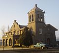
.jpg)   _(cropped).jpg) Top: Nevada-California-Oregon Railway Building (left), Modoc County Courthouse (right); bottom: Sacred Heart Church (left), Niles Theater (right)
|
||
|
||
| Motto(s):
"Where the West Still Lives"
|
||

Location of Alturas in Modoc County, California
|
||
| Country | United States | |
| State | California | |
| County | Modoc | |
| Incorporated | September 16, 1901 | |
| Area | ||
| • Total | 2.85 sq mi (7.39 km2) | |
| • Land | 2.84 sq mi (7.35 km2) | |
| • Water | 0.02 sq mi (0.05 km2) 0.57% | |
| Elevation | 4,370 ft (1,332 m) | |
| Population
(2020)
|
||
| • Total | 2,715 | |
| • Density | 957.33/sq mi (369.61/km2) | |
| Time zone | UTC-8 (Pacific Time Zone) | |
| • Summer (DST) | UTC-7 (PDT) | |
| ZIP code |
96101
|
|
| Area code | 530 | |
| FIPS code | 06-01444 | |
| GNIS feature IDs | 277469, 2409688 | |

Alturas is a city in Northern California. Its name means "Heights" in Spanish. It is also known as Kasalektawi in the Achumawi language. Alturas is the main city and county seat of Modoc County, California.
The city is located in the Shasta Cascade area. It sits where the south and north forks of the Pit River meet. Alturas is about 4,370 feet (1,332 meters) above sea level. In 2020, about 2,715 people lived there. Alturas is an important center for business in its region.
Contents
History of Alturas
Alturas was first a village of the Achomawi (Pit River) people. They called it Kosealekte or Kasalektawi. Later, the city was known as Dorris Bridge. It was named after Pressley and James Dorris. They built a bridge over the Pit River in this spot.
The Dorris Bridge post office opened in 1871. The town's name changed to Dorrisville in 1874. Then, in 1876, it became Alturas. This name means "heights" in Spanish. By 1880, 148 people lived there.
Alturas grew over the next 20 years. It officially became a city on September 16, 1901. In 1874, Alturas became the county seat of Modoc County. This happened even though other towns like Adin and Cedarville were bigger at the time.
Geography of Alturas
Alturas is in the far northeastern part of California. It is located at 41°29′14″N 120°32′33″W / 41.48722°N 120.54250°W. The city is built around the North Fork of the Pit River. This is close to where it joins the South Fork.
To the east, you can see the tall Warner Mountains. To the south are wetlands and fields where wild rice grows. The large Modoc Plateau is to the north.
The city covers about 2.4 square miles (6.2 square kilometers) of land. A very small part, about 0.57%, is covered by water.
Climate in Alturas
Alturas has a cold semi-arid climate. This means it gets dry weather but also has cold winters. The average temperature in January is around 43°F (6°C) for the high and 20.6°F (-6°C) for the low. In July, the average high is about 89.1°F (31.7°C) and the low is 47.2°F (8.4°C).
It gets very hot some days, with temperatures reaching 90°F (32°C) or higher about 40 days a year. It also gets very cold, with temperatures at or below freezing (32°F or 0°C) for over 195 days a year. The highest temperature ever recorded was 107°F (42°C). The lowest was -34°F (-37°C). Even in summer, nights can be cool.
Alturas gets about 11.68 inches (297 mm) of rain each year. It snows too, with an average of about 30.9 inches (78 cm) of snow per season.
| Climate data for Alturas, California (Alturas Municipal Airport), 1991–2020 normals, extremes 1935–present | |||||||||||||
|---|---|---|---|---|---|---|---|---|---|---|---|---|---|
| Month | Jan | Feb | Mar | Apr | May | Jun | Jul | Aug | Sep | Oct | Nov | Dec | Year |
| Record high °F (°C) | 69 (21) |
72 (22) |
82 (28) |
85 (29) |
95 (35) |
105 (41) |
107 (42) |
106 (41) |
106 (41) |
93 (34) |
82 (28) |
71 (22) |
107 (42) |
| Mean maximum °F (°C) | 56.6 (13.7) |
60.4 (15.8) |
69.4 (20.8) |
76.5 (24.7) |
85.3 (29.6) |
93.2 (34.0) |
99.1 (37.3) |
98.0 (36.7) |
92.8 (33.8) |
82.1 (27.8) |
69.5 (20.8) |
55.2 (12.9) |
100.3 (37.9) |
| Mean daily maximum °F (°C) | 43.0 (6.1) |
46.6 (8.1) |
52.7 (11.5) |
58.4 (14.7) |
67.9 (19.9) |
78.2 (25.7) |
89.1 (31.7) |
87.3 (30.7) |
79.7 (26.5) |
65.7 (18.7) |
50.8 (10.4) |
41.0 (5.0) |
63.4 (17.4) |
| Daily mean °F (°C) | 31.8 (−0.1) |
34.8 (1.6) |
39.6 (4.2) |
44.3 (6.8) |
52.5 (11.4) |
60.2 (15.7) |
68.2 (20.1) |
65.8 (18.8) |
58.5 (14.7) |
47.5 (8.6) |
37.7 (3.2) |
30.5 (−0.8) |
47.6 (8.7) |
| Mean daily minimum °F (°C) | 20.6 (−6.3) |
23.0 (−5.0) |
26.5 (−3.1) |
30.1 (−1.1) |
37.2 (2.9) |
42.2 (5.7) |
47.2 (8.4) |
44.2 (6.8) |
37.2 (2.9) |
29.3 (−1.5) |
24.5 (−4.2) |
20.0 (−6.7) |
31.8 (−0.1) |
| Mean minimum °F (°C) | −0.5 (−18.1) |
6.2 (−14.3) |
11.1 (−11.6) |
17.5 (−8.1) |
23.9 (−4.5) |
30.3 (−0.9) |
36.4 (2.4) |
— | 26.0 (−3.3) |
15.5 (−9.2) |
5.9 (−14.5) |
−0.6 (−18.1) |
−7.1 (−21.7) |
| Record low °F (°C) | −32 (−36) |
−33 (−36) |
−7 (−22) |
7 (−14) |
14 (−10) |
21 (−6) |
28 (−2) |
26 (−3) |
15 (−9) |
0 (−18) |
−17 (−27) |
−34 (−37) |
−34 (−37) |
| Average precipitation inches (mm) | 1.31 (33) |
1.09 (28) |
1.38 (35) |
1.47 (37) |
1.26 (32) |
0.70 (18) |
0.29 (7.4) |
0.27 (6.9) |
0.35 (8.9) |
0.89 (23) |
1.20 (30) |
1.47 (37) |
11.68 (296.2) |
| Average snowfall inches (cm) | 8.4 (21) |
6.2 (16) |
5.4 (14) |
2.9 (7.4) |
0.9 (2.3) |
0.0 (0.0) |
0.0 (0.0) |
0.0 (0.0) |
0.0 (0.0) |
0.3 (0.76) |
3.5 (8.9) |
6.6 (17) |
34.2 (87.36) |
| Average extreme snow depth inches (cm) | 4.4 (11) |
3.0 (7.6) |
2.6 (6.6) |
1.1 (2.8) |
0.4 (1.0) |
0.0 (0.0) |
0.0 (0.0) |
0.0 (0.0) |
0.0 (0.0) |
0.2 (0.51) |
1.6 (4.1) |
2.6 (6.6) |
5.6 (14) |
| Average precipitation days (≥ 0.01 in) | 11.0 | 10.7 | 11.3 | 10.7 | 8.6 | 4.6 | 2.0 | 2.1 | 2.9 | 5.2 | 9.6 | 12.1 | 90.8 |
| Average snowy days (≥ 0.1 in) | 4.0 | 3.3 | 2.6 | 1.4 | 0.4 | 0.0 | 0.0 | 0.0 | 0.0 | 0.3 | 1.8 | 3.3 | 17.1 |
| Source 1: NOAA | |||||||||||||
| Source 2: National Weather Service (snow/snow days 1935–2018) | |||||||||||||
People Living in Alturas
| Historical population | |||
|---|---|---|---|
| Census | Pop. | %± | |
| 1880 | 148 | — | |
| 1910 | 916 | — | |
| 1920 | 979 | 6.9% | |
| 1930 | 2,338 | 138.8% | |
| 1940 | 2,090 | −10.6% | |
| 1950 | 2,819 | 34.9% | |
| 1960 | 2,819 | 0.0% | |
| 1970 | 2,799 | −0.7% | |
| 1980 | 3,025 | 8.1% | |
| 1990 | 3,231 | 6.8% | |
| 2000 | 2,892 | −10.5% | |
| 2010 | 2,827 | −2.2% | |
| 2020 | 2,715 | −4.0% | |
| U.S. Decennial Census | |||
In 2020, Alturas had a population of 2,715 people. Most people, about 86%, were White. There were also people who identified as African American, Native American, Asian, and Pacific Islander. About 12.3% of the population was Hispanic or Latino.
In 2010, there were 1,238 households in Alturas. About 31.6% of these households had children under 18 living there. The average household had about 2.27 people. The median age of people in Alturas was about 39.9 years old.
Economy in Alturas
Alturas is an important center for the area's economy. Many government offices are located here. These include the headquarters for the Modoc National Forest and the Bureau of Land Management. The Modoc National Wildlife Refuge is also nearby.
The city is a trade center for farming. Farmers in the area raise beef and sheep. They also grow potatoes, alfalfa, and lumber. Even though there are many outdoor activities like hunting and fishing, tourism is not a big part of the economy. This is because Alturas is in a remote location.
Local, state, and federal governments are the biggest employers in Alturas. The timber industry used to be very strong. However, it faced challenges in the early 1980s and is no longer as big.
The Modoc Joint Unified School District has its main office in Alturas. Also, the Alturas Rancheria, a group of Pit River Indians, runs a small casino just outside the city.
Getting Around Alturas
Alturas is on U.S. Route 395 and California State Route 299. U.S. 395 comes from the south, connecting to places like Susanville. State Route 299 comes from the west, from Redding. These two highways join together in Alturas. They then head northeast towards places like Lakeview, Oregon and Cedarville.
The Union Pacific Railroad and the Lake County Railroad also serve the area. For air travel, there is the Alturas Municipal Airport. It is a public airport located about 1 mile (1.6 km) west of the city center.
Notable People
- Kayte Christensen, a basketball player in the WNBA
- Ernest S. Brown, a former United States Senator from Nevada
- John E. Raker (1863–1926), a Congressman from California
- Robert "Top Gun" Hight, a NHRA drag racer
Images for kids
-
The Nevada-California-Oregon Railway Building, built 1917–18
-
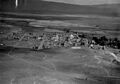
Alturas in 1920
-
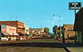
Downtown Alturas in 1975
-
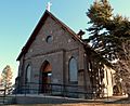
Sacred Heart Church of the Catholic Diocese of Sacramento
-
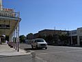
Downtown Alturas
-

The historic Modoc County Courthouse, completed in 1914
-
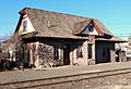
NCO Railway Depot, built 1908
.jpg)
.jpg)


.jpg)


See Also
 In Spanish: Alturas (California) para niños
