Warner Mountains facts for kids
Quick facts for kids Warner Mountains |
|
|---|---|

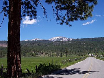
The Jess Valley and the Warner Mountains in northeastern California
|
|
| Highest point | |
| Peak | Eagle Peak |
| Elevation | 9,892 ft (3,015 m) |
| Geography | |
| Country | United States |
| Range coordinates | 41°26′59.619″N 120°15′3.807″W / 41.44989417°N 120.25105750°W |
| Topo map | USGS Davis Creek |
The Warner Mountains are a long mountain range in the western United States. They stretch about 85-mile (137 km) from north to south. You can find them in northeastern California and southern Oregon.
This range is part of a larger area called the Basin and Range Province. It goes through Lassen County, California, Modoc County, California, and Lake County, Oregon. The tallest point is Eagle Peak. It stands 9,892 feet (3,015 m) high. The Warner Mountains are also part of national forests. These include the Modoc National Forest in California and the Fremont National Forest in Oregon.
Contents
Exploring the Warner Mountains' Geography
The Warner Mountains are unique. They are not part of the Sierra Nevada or the Cascade Range. Instead, they belong to the Great Basin Ranges. This area is mostly dry and has few people living there. It's in the northeastern part of California and south-central Oregon.
How the Mountains Were Formed
The Warner Mountains show a special type of landform. It's called horst and graben topography. Imagine huge blocks of Earth's crust. Some blocks moved up (the mountains), and others sank down (the valleys). These sunken valleys often hold temporary lakes.
Lakes and Valleys Nearby
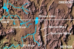
On the eastern side of the mountains, you'll see the Surprise Valley in California. In Oregon, there's the Warner Valley. These valleys have several lakes.
- In California, near the Nevada border, are Upper Alkali Lake, Middle Alkali Lake, and Lower Alkali Lake.
- In Oregon, you'll find the Warner Lakes, which include Crump Lake and Hart Lake.
To the west, the mountains overlook a farming area. Rivers like the Pit River flow through here. The Pit River eventually joins the Sacramento River. Another important lake is Goose Lake. It's about 28-mile (45 km) long. This lake sits on the border of California and Oregon. Goose Lake usually doesn't flow into other rivers. It only drained into the Pit River a couple of times in recorded history. It even dried up completely in some years.
A Look at Warner Mountains History
The Warner Mountains have a rich history. Many people traveled through them long ago.
The Applegate Trail and Gold Rush
A famous path called the Fandango Pass crosses the Warner Mountains. This pass was part of the Lassen-Applegate Trail. From 1846 to 1850, many pioneers used this trail. They were heading to the Willamette Valley in Oregon or the gold fields of California. After reaching Goose Lake, groups often split up. Some continued to Oregon, and others went to search for gold.
In 1912, there was a small gold rush in the Warner Mountains. Mines opened briefly in an area called the High Grade Mining District. This was right next to the Oregon border in Modoc County, California.
Logging in the Mountains
Starting around 1920, a lot of lumber was taken from the Warner Mountains. Giant Ponderosa pine trees were cut down. Their logs went to sawmills and factories in Lakeview, Oregon; Alturas, California; and Willow Ranch, California. The town of Willow Ranch even had a large sawmill and box factory. It was a company town with over 1,000 people in the 1930s and 1940s. This operation closed down in 1958.
Who Are the Warner Mountains Named After?
The Warner Mountains are named after Captain William H. Warner. He was an explorer with the U.S. Army Corps of Topographical Engineers. In 1849, he was exploring a possible route for a railroad. During his journey, he died during an encounter with Native Americans on September 26, 1849. His body was never found. His name first appeared on maps of the range in 1866.
Camp Warner and Crook Peak
In 1867, Camp Warner was built in the northern part of the Warner Range in Oregon. General George Crook established this camp. It was meant to help keep peace with the Native American tribes. The camp was closed in 1874. A mountain peak in the Warner Range, Crook Peak, is named after General Crook. It stands 7,834 feet (2,388 m) high.
 | John T. Biggers |
 | Thomas Blackshear |
 | Mark Bradford |
 | Beverly Buchanan |


