
Warner Valley facts for kids
Quick facts for kids Warner Valley |
|
|---|---|

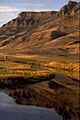
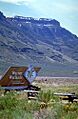
Hart Mountain overlooking the Warner Wetlands
|
|
 |
|
| Geography | |
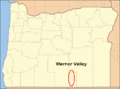
| Location | Lake County, Oregon |
| Borders on | Hart Mountain (east) Warner Mountains (west) |
The Warner Valley is a long valley in south-central Oregon, a state in the United States. It's a quiet, remote area known for its chain of beautiful lakes and wetlands called the Warner Lakes.
Long ago, Native American people lived in the Warner Valley for thousands of years. Later, in the 1800s, European explorers arrived. The United States Army even built a fort here in 1867, called Fort Warner. Today, people mostly raise livestock (like cattle) in the valley. It's also a great place for outdoor activities like hunting, fishing, bird watching, and seeing wildlife.
Contents
Where is Warner Valley?
The Warner Valley is in south-central Oregon. It stretches about 60 miles (97 km) long and 8 miles (13 km) wide. Most of it is in Lake County, but the northern part goes into Harney County.
The valley has two main parts: the South Warner Valley and the North Warner Valley. They meet where the valley gets narrower, between Crump Lake and Hart Lake.
The sides of the South Warner Valley have steep cliffs that rise 1,000 to 2,000 feet (300 to 610 m) high. The eastern cliffs run all the way along the valley. On the western side, the cliffs turn into rolling hills further north. The eastern edge of the valley is Hart Mountain, a huge cliff that rises 3,600 feet (1,100 m) above the valley floor. The highest point on Hart Mountain is Warner Peak, which is 8,065 feet (2,458 m) above sea level.
The valley floor is home to the Warner Lakes. Long ago, the entire valley was covered by one giant lake! Over time, the water level dropped, leaving behind the chain of lakes and marshlands we see today. From south to north, the main lakes include Pelican Lake, Crump Lake, Hart Lake, Anderson Lake, Swamp Lake, Mugwump Lake, Flagstaff Lake, Upper Campbell Lake, Lower Campbell Lake, Stone Corral Lake, Turpin Lake, and Bluejoint Lake. Crump Lake is actually 123 feet (37 m) higher than Bluejoint Lake because the valley slopes downwards to the north.
How Warner Valley Was Formed
The land around Warner Valley is a high volcanic plateau. The valley itself was likely formed by massive faulting. This is when huge cracks in the Earth's crust caused the valley floor to drop down, while the land around it was pushed up, creating the high valley walls. The Warner Lakes then formed in the low parts of the valley after these movements stopped.
The valley is surrounded by high, steep walls called escarpments. The biggest one is Hart Mountain on the east side, which towers 3,600 feet (1,100 m) above the valley floor. The cliffs in the southern part of the valley are also very high, rising 1,500 to 2,000 feet (460 to 610 m). These cliffs show layers of ancient lava flows and volcanic ash from millions of years ago.
Warner Valley is an alluvial basin, meaning it's filled with sediments carried by water. The lakes are what's left of a huge lake that covered the valley during the Ice Age, about 200 feet (61 m) deep! Today, these lakes are endorheic, which means they don't flow out to the ocean.


What is the Climate Like?
The climate in Warner Valley is like a high desert. It can be harsh, especially in the north, because there isn't a high rim to block the winds.
Local winds are common due to the different temperatures in the valley and on the surrounding mountains. These winds are strongest where canyons open into the valley.
Frost is common in the valley until late spring and starts again in early fall. This means the growing season for plants is only about 100 days long. Most of the rain falls in May and June, while summers and falls are very dry. Winter snowfall in the valley is usually light, but it can get very cold. The higher mountains get much more snow, which melts and feeds the streams that flow into the valley.
Animals and Plants of Warner Valley

Warner Valley has many different types of homes for animals, called habitats. These include lakes, marshes, riverbanks (riparian areas), grasslands, sagebrush areas, dry forests, and rimrock cliffs. The elevation ranges from about 4,500 feet (1,400 m) on the valley floor to over 8,000 feet (2,400 m) at Warner Peak.
Along the lake shores, you'll find marsh grasses. In the riverbank areas, there are wild roses, choke cherry trees, wild plums, cottonwoods, and willows. Away from the wetlands, the valley becomes very dry. In the northern part, you'll mostly see dwarf sagebrush, greasewood, and Western Juniper trees.
The valley is home to many mammals, birds, and migrating waterfowl. There are 42 mammal species in the Warner Valley-Hart Mountain area. These include pronghorn, bighorn sheep, elk, mule deer, cougars, bobcats, and coyotes. Smaller mammals like jackrabbits, ground squirrels, and chipmunks also live here.
About 239 species of birds either live in or pass through the Warner Valley. Birds that nest around Crump Lake and Hart Lake include American white pelicans, double-crested cormorants, willets, Wilson's phalaropes, Canada geese, gadwalls, northern shovelers, black-crowned night herons, and many kinds of ducks and terns. You might also see sandhill cranes, white-faced ibis, great white egrets, and American avocets in the marshes. At the Warner Wetlands Interpretive Site, you can watch American bitterns, black-necked stilts, cinnamon teal, tundra swans, Brewer's blackbirds, western meadowlarks, swallows, and nighthawks.
In the summer, dusky flycatchers, yellow warblers, orange-crowned warblers, house wrens, and spotted towhees are common in the riverbank areas. In the sagebrush and grasslands, you might spot horned larks, Brewer's sparrows, vesper sparrows, common ravens, sage thrashers, sagebrush sparrows, black-throated sparrows, and greater sage grouse. In the rocky cliff areas, look for chukars, rock wrens, canyon wrens, cliff swallows, and barn swallows. Larger birds like great horned owls, long-eared owls, prairie falcons, golden eagles, and bald eagles also live here.
A Look at Warner Valley's Past
Native Americans used the Warner Valley for thousands of years. You can still find many petroglyphs (ancient rock carvings) in the valley, some thought to be 12,000 years old! The Greaser Petroglyph Site in the South Warner Valley is a special historical place.
The first European explorer to likely visit the valley was John Work in 1832. He described a "valley of lakes" that sounds a lot like Warner Valley. Later, Captain John C. Fremont explored the valley in December 1843. He called it Christmas Valley because his group camped near Hart Lake on Christmas Day.
In 1849, Captain William H. Warner, an Army engineer, explored the valley. Sadly, he was ambushed and killed by Native Americans just south of the valley. In 1864, Lieutenant Colonel C. S. Drew named the valley in honor of Captain Warner.

In 1865, the Army decided they needed a fort in Warner Valley to stop Native American raiding parties. Soldiers tried to build a fort on the west side of the lakes, but they couldn't cross the wetlands. So, they built a winter camp on the east side, which was a very difficult winter. In 1867, General George Crook ordered the camp to move to the west side. To do this, he had soldiers build a bridge across the narrow channel between Hart Lake and Crump Lake. This bridge, known as the Stone Bridge, was finished that summer, and the new fort, Fort Warner, was built. By 1874, the Native American raids had stopped, and Fort Warner was no longer needed, so it was abandoned. Nothing is left of the fort today, but the Stone Bridge still stands and is a historic landmark.
In 1865, the U.S. Congress approved building the Oregon Central Military Wagon Road. This road was supposed to go from Eugene, Oregon, to Fort Boise in Idaho. The company building the road could claim large areas of land for every mile built. So, they planned the road to go through the best land, including the Warner Valley, crossing the lakes at the Stone Bridge.
This road project was mostly a way for the company to get valuable public lands. They ended up with thousands of acres of good grazing land in Warner Valley. For many years, there were legal fights over who owned this land, which stopped people from settling there. Eventually, the U.S. Supreme Court decided the case. The land was then sold off in smaller pieces in 1909.
People didn't really start settling in Warner Valley until the late 1800s. For example, the land where Fort Warner used to be was settled in 1889. Post offices were opened in Plush, Oregon in 1888 and in Adel in 1896.
What Do People Do in Warner Valley Today?
_(lakDA0126).jpg)
Today, agriculture is the main way people make money in Warner Valley. Most of the private land is used for ranching cattle. Crops grown here are usually used to feed animals in winter. Because the growing season is short, the main crops are wild hay, alfalfa, clover, and timothy-grass. Grains like wheat, oats, rye, and barley can also be grown.
Much of the valley is public land managed by the Bureau of Land Management. These public lands offer many fun things to do, like hunting, fishing, bird watching, seeing wildlife, boating, and camping. However, some activities depend on how much water is in the Warner Lakes, which can change a lot. You can find Crappie, smallmouth bass, and bullhead catfish in the lakes. Trout, including Great Basin redband trout, live in Twentymile Creek, Deep Creek, and Honey Creek. There are no official campgrounds, but you can camp in many places on the public lands. The Bureau of Land Management's Warner Wetlands Interpretive Site at Hart Bar has restrooms, picnic tables, and hiking trails.
Communities in Warner Valley
There are no big cities in Warner Valley. The closest city is Lakeview, which is the main town for Lake County.
- Adel is a small community in the South Warner Valley.
- Plush is another small community, located in the North Warner Valley.
Images for kids
-
Hart Mountain overlooking the Warner Wetlands
-
Map of Warner Valley, Oregon
-
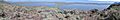
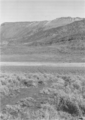
View of the Warner Valley looking west from Hart Mountain
-
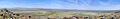
The same view during low water in June 2015. Upper Campbell Lake is to the left, Campbell Lake to the right.
-
Warner Wetlands Interpretive Site
-
Oregon Central Military Wagon Road
-
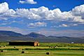
Hay stacks in fields south of Adel
