Harney County, Oregon facts for kids
Quick facts for kids
Harney County
|
||
|---|---|---|
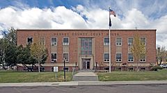
Harney County Courthouse in Burns
|
||
|
||
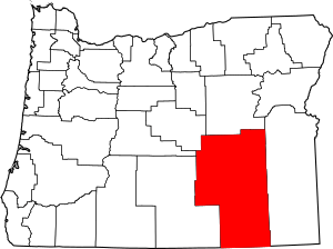
Location within the U.S. state of Oregon
|
||
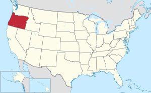 Oregon's location within the U.S. |
||
| Country | ||
| State | ||
| Founded | February 23, 1889 | |
| Named for | William S. Harney | |
| Seat | Burns | |
| Largest city | Burns | |
| Area | ||
| • Total | 10,226 sq mi (26,490 km2) | |
| • Land | 10,133 sq mi (26,240 km2) | |
| • Water | 93 sq mi (240 km2) 0.9%% | |
| Population
(2020)
|
||
| • Total | 7,495 | |
| • Estimate
(2023)
|
7,440 |
|
| • Density | 0.7/sq mi (0.3/km2) | |
| Time zone | UTC−8 (Pacific) | |
| • Summer (DST) | UTC−7 (PDT) | |
| Congressional district | 2nd | |
Harney County is one of the 36 counties in the U.S. state of Oregon. In 2020, about 7,495 people lived there. This makes it one of Oregon's least populated counties. The main town, called the county seat, is Burns. Harney County was created in 1889. It is named after William S. Harney, a military officer who was well-known in the Pacific Northwest.
Harney County is a rural area in southeastern Oregon. It is about a five-hour drive from Portland, Oregon. It is also about a three-hour drive from Boise, Idaho. The county shares borders with Grant County to the north and Malheur County to the east. To the south, it borders Washoe County, Nevada and Humboldt County, Nevada. To the west, it borders Lake, Deschutes, and Crook counties.
Harney County is the largest county in Oregon. It covers about 10,226 square miles (26,485 square kilometers). This area is larger than six U.S. states! It is also the most spread out county in Oregon. There are only about 0.7 people per square mile (0.3 per square kilometer). The county has only two official cities. Burns is the county seat and the larger city. Hines is the other city.
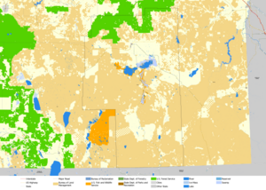
About 75 percent of the county's land is owned by the U.S. government. Different groups manage this land. These include the Bureau of Land Management and the U.S. Forest Service. Parts of the Ochoco National Forest and Malheur National Forest are also in the county. The Burns Paiute Indian Reservation is also located here. This reservation is home to the Burns Paiute Tribe.
Harney County has a "high desert" landscape. This means it does not get much rain. About 500 ranches and farms are in the county. They raise cattle, make dairy products, and grow hay. There are about 14 cattle for every person in the county! Besides ranching and farming, forestry is also important.
The county is important for nature and outdoor fun. Harney County and nearby Grant County have the largest Ponderosa pine forest in the country. The county has also worked to protect the sage grouse. In 2014, ranchers signed agreements to help protect this bird. People visit the county for hunting, fishing, and camping.
Contents
History of Harney County
The Native American people who lived here first were the Northern Paiute. They sometimes had conflicts with other tribes. In 1826, Peter Skene Ogden was the first known European to explore this area. He was leading a group of fur traders.
Harney County was formed from the southern part of Grant County. This happened on February 25, 1889. There was a big disagreement about where the county seat should be. After some arguments, Burns became the county seat in 1890.
The Malheur River Indian Reservation was created in 1871. It was a place for the Northern Paiute people in Oregon to live. However, the government closed the reservation after the Bannock War in 1878. Today, the descendants of these people are part of the Burns Paiute Tribe. This tribe has about 341 members. Some tribal members live on the Burns Paiute Indian Colony near Burns.
Recent Events: 2016 Occupation
In 2016, a group of armed protesters took over the headquarters of the Malheur National Wildlife Refuge. They were protesting the jail sentences of two ranchers. These ranchers had been found guilty of setting fires that spread to the wildlife refuge. The leaders of the protest were arrested on January 26, 2016. The last few protesters gave up on February 11, 2016.
Geography and Nature
Harney County is the largest county in Oregon by land area. It is also the tenth-largest county in the United States, not counting areas in Alaska.
Steens Mountain is the most important natural landmark in the county. It rises to about 9,700 feet (2,957 meters) above sea level. It stretches for many miles across a mostly flat area. To the southeast is the Alvord Desert. This is the driest place in Oregon. South of Steens Mountain are the Pueblo Mountains. North of Steens Mountain is the Harney Basin. This area includes Malheur Lake and Harney Lake.
Neighboring Counties
- Crook County - northwest
- Grant County - north
- Malheur County - east
- Humboldt County, Nevada - south
- Washoe County, Nevada - southwest
- Lake County - west
- Deschutes County - northwest
Time Zones
Harney County is officially in the Pacific Time Zone. However, the small community of Drewsey sometimes uses the Mountain Time Zone.
Protected Natural Areas
- Malheur National Forest (part)
- Malheur National Wildlife Refuge
- Ochoco National Forest (part)
Population and People
| Historical population | |||
|---|---|---|---|
| Census | Pop. | %± | |
| 1890 | 2,559 | — | |
| 1900 | 2,598 | 1.5% | |
| 1910 | 4,059 | 56.2% | |
| 1920 | 3,992 | −1.7% | |
| 1930 | 5,920 | 48.3% | |
| 1940 | 5,374 | −9.2% | |
| 1950 | 6,113 | 13.8% | |
| 1960 | 6,744 | 10.3% | |
| 1970 | 7,215 | 7.0% | |
| 1980 | 8,314 | 15.2% | |
| 1990 | 7,060 | −15.1% | |
| 2000 | 7,609 | 7.8% | |
| 2010 | 7,422 | −2.5% | |
| 2020 | 7,495 | 1.0% | |
| 2023 (est.) | 7,440 | 0.2% | |
| U.S. Decennial Census 1790–1960 1900–1990 1990–2000 2010–2020 |
|||
In 2010, there were 7,422 people living in Harney County. Most people were white (91.9%). About 3.1% were American Indian. People of Hispanic or Latino background made up 4.0% of the population.
The average age of people in the county was 45.2 years old. About 26.4% of homes had children under 18 living there. The average household had 2.28 people.
Communities in Harney County
Cities
Census-designated place
Unincorporated communities
Ghost towns
Economy and Jobs
Harney County's economy has always relied on three main things: ranching, raising sheep, and timber (wood). When the railroad came in 1883, it helped the cattle industry grow. However, it also brought more farmers and sheep ranchers. This led to more competition for good land. For a while, catching and breeding wild horses was also a good business.
Harney County shares the largest Ponderosa Pine forest in the country with Grant County. The county also has many wild animals, places to camp, and great fishing. These activities have made outdoor recreation a fast-growing part of the economy.
Even though people could claim land from 1862 to 1934, the U.S. Bureau of Land Management still owns most of the land. They own about 62% of the land in the county. The Malheur National Wildlife Refuge was created in 1908. It was made larger in 1936. This refuge now covers about 159,872 acres (647 square kilometers).
Education and Learning
Harney County has several school districts:
- K-12: Harney County School District 3 (for Burns and Hines)
- High school: Harney County Union High School District 1J
- Elementary school districts
- Harney County School District 4 (Crane Elementary)
- Diamond School District 7
- Double O School District 28
- Drewsey School District 13
- South Harney School District 33 (Fields)
- Frenchglen School District 16
- Pine Creek School District 5
- Suntex School District 10
Harney County does not have its own community college district. However, students can attend Treasure Valley Community College through a special agreement. TVCC has an outreach center in Burns.
The Harney County Library is located in Burns.
See also
 In Spanish: Condado de Harney para niños
 | Madam C. J. Walker |
 | Janet Emerson Bashen |
 | Annie Turnbo Malone |
 | Maggie L. Walker |


