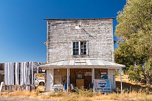
Lawen, Oregon facts for kids
Quick facts for kids
Lawen, Oregon
|
|
|---|---|

The Old Lawen Store, Highway 78
|
|
| Country | United States |
| State | Oregon |
| County | Harney |
| Elevation | 4,108 ft (1,252 m) |
| Time zone | UTC-8 (PST) |
| • Summer (DST) | UTC-7 (PDT) |
| ZIP codes |
97720
|
| Area code(s) | 541 |
| Coordinates and elevation from United States Geological Survey | |
Lawen is a small place in Harney County, Oregon, United States. It is an "unincorporated community," which means it's not an official city or town with its own local government. Lawen has its own post office with the ZIP code 97720.
You can find Lawen along Oregon Route 78. It is just south of where this road meets other main roads like Oregon Route 205, U.S. Route 20, and U.S. Route 395. These roads are near Burns, which is the main city and government center for Harney County. Lawen is also located north of the East Fork Silvies River and Malheur Lake.
In 2023, a writer named Taylor Perse from the Eugene Weekly newspaper said that Lawen looked like a "ghost town." This means it has only a few old, worn-down buildings left.
Climate in Lawen
Lawen has a type of weather called a semi-arid climate. This means it is usually dry, but not quite a desert. It gets some rain, but not a lot. On climate maps, this kind of weather is often shown as "BSk."
Schools and Learning
Lawen is part of the Harney County School District 4. This district includes Crane School, which teaches students from kindergarten through 8th grade. For high school, students go to Crane Union High School, which is part of the Harney County Union High School District 1J.
Crane Union High School first opened in Lawen in 1918. However, it moved to Crane in 1920.
Harney County does not have its own community college. But students can still take college classes through a special agreement. They can attend Treasure Valley Community College, which has a learning center in Burns.
 | Georgia Louise Harris Brown |
 | Julian Abele |
 | Norma Merrick Sklarek |
 | William Sidney Pittman |


