
Silvies River facts for kids
Quick facts for kids Silvies River |
|
|---|---|

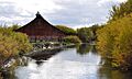
View from Oregon Route 78 bridge near Burns
|
|

Location of the mouth of Silvies River in Oregon
|
|
| Country | United States |
| State | Oregon |
| County | Grant and Harney |
| Physical characteristics | |
| Main source | Aldrich Mountains Grant County 5,598 ft (1,706 m) 44°07′19″N 119°13′53″W / 44.12194°N 119.23139°W |
| River mouth | East Fork and West Fork distributaries south of Burns, Harney County 4,150 ft (1,260 m) 43°34′05″N 119°02′04″W / 43.56806°N 119.03444°W |
| Length | 119 mi (192 km) |
| Basin features | |
| Basin size | 1,273 sq mi (3,300 km2) |
The Silvies River is a river in the state of Oregon in the United States. It flows for about 119 miles (192 km) (192 km) through Grant and Harney counties. This river helps drain a large area of land, about 1,273 square miles (3,300 km2) (3,297 km²) in the northern Harney Basin.
Contents
Where Does the Silvies River Start and End?
The Silvies River begins high up in the Aldrich Mountains. Its starting point is about 10 miles (16 km) (16 km) south of a town called Mount Vernon in Grant County.
How Does the River Flow?
The river generally flows south. As it travels, it passes close to the towns of Seneca and Burns. Near Burns, the river splits into two smaller branches. These branches are called the East Fork Silvies River and the West Fork Silvies River.
Where Do the River Branches Go?
Both of these branches eventually flow into Malheur Lake. This lake is located about 25 miles (40 km) (40 km) southeast of Burns.
What Animals Live in the Silvies River?
The Silvies River is home to different kinds of fish. Most of the river flows through private land, so public access is limited.
What Fish Live Upstream?
In the upper parts of the river, you can find many redband trout. These fish are a type of trout known for their reddish color.
What Fish Live Downstream?
Further down the river, past Seneca, other fish become more common. These include smallmouth bass, yellow perch, and carp.
What Can You Do at the Silvies River?
Even though much of the river is private, there are some public spots for fun activities.
Activities at Five-Mile Dam
About 5 miles (8 km) (8 km) north of Burns, there is a place called Five-Mile Dam. The water behind this dam forms a pool. This pool is a popular spot for swimming, canoeing, and fishing.
Images for kids
-
View from Oregon Route 78 bridge near Burns
