
Harney Basin facts for kids
Quick facts for kids Harney Basin |
|
|---|---|

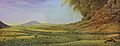
Harney Basin near Burns, Oregon
|
|

The Harney Basin (dashed yellow perimeter)
|
|
| Floor elevation | 4,111 ft (1,253 m) |
| Area | 3,855 km2 (1,488 sq mi) |
| Geography | |
| River | Donner und Blitzen River; Silvies River |
| Lake | Harney Lake; Malheur Lake |
The Harney Basin is a special kind of valley in southeastern Oregon, United States. It's known as an endorheic basin, which means that water flows into it but doesn't flow out to the ocean. Think of it like a giant bathtub where all the rain and river water collects.
This basin is one of the least populated areas in the contiguous United States. It's mostly found in northern Harney County, Oregon. The area is surrounded by mountains and a flat plain formed by ancient volcanoes. The basin covers about 1,490 square miles (3,855 square kilometers). It includes two main lakes: Malheur Lake and Harney Lake. Malheur Lake has fresh water, while Harney Lake is salty and alkaline.
To the north, the Harney Basin is bordered by the southern part of the Blue Mountains. A large mountain ridge called Steens Mountain separates it from the Alvord Desert to the southeast. No rivers cross the volcanic plains that separate the basin from the Klamath River area to the southwest. The basin also has important archaeological sites. These sites show that people lived here a very long time ago.
Contents
Geography and Lakes

The middle of the Harney Basin gets about 6 inches (150 mm) of rain each year. The mountains around it get more, about 15 inches (380 mm) per year. The center of the basin is flat. This is where Malheur and Harney lakes are located. These lakes collect water from rivers that start in the surrounding mountains. The Silvies River flows in from the north, and the Donner und Blitzen River flows in from the south.
Harney Lake is the lowest point in the basin. Sometimes, it connects to Malheur Lake, but often they are separated by shifting sand dunes. Both lakes change a lot. In wet years, they are full of open water. In dry years, they become marshy areas. The wetlands around these lakes are like an oasis. They provide a home for many birds, especially migratory birds. About 2.5 million ducks visit these wetlands every year! The area around Malheur Lake is protected as part of the Malheur National Wildlife Refuge.
Harney County, Oregon, had about 7,422 people living there in 2010. The town of Burns is the only community with more than 1,000 people. Most of the economy in this area comes from dryland ranching. This means raising livestock without much irrigation because water from the rivers is limited.
Volcanic Features
The Harney Basin area has many interesting volcanic features. These include old lava flows and ash deposits. These features are part of a larger area called the High Lava Plains Province. One notable feature is the Malheur Maar, which is a type of volcanic crater.
Wetlands and Waterways
The Harney-Malheur Lakes area is a large watershed within the Great Basin. It covers about 1,420 square miles (3,678 square kilometers). The Donner und Blitzen River watershed also flows into Malheur Lake. This river area includes a large part of the Malheur National Wildlife Refuge. The High Desert Wetlands ecoregion includes a big area around Harney and Malheur Lakes. These wetlands are very important for wildlife.
History of Harney Basin
The Harney Basin was formed about 32,000 years ago. This happened when lava flows created the Malheur Gap. This gap separated the basin's water system from the Malheur River, which flows into the Snake River.
Archaeological findings show that people have lived in the basin for at least 10,000 years. Studies of ancient pollen tell us that the climate here has changed a lot since the last Ice Age. There is also evidence of ancient fishing methods. Some fish species found here today are usually only found in the Columbia River basin. This suggests that the Harney Basin might have been connected to the Columbia River at some point. In very wet years long ago, Malheur Lake was deep enough (about 25 feet or 7.6 meters) to overflow the Malheur Gap. Today, even in the wettest years, the lake doesn't get deeper than 10 feet (3 meters).
In the 1800s, the Northern Paiute tribe lived in the basin. Fur trappers from the Hudson's Bay Company explored the area in the 1820s. The Harney Basin was far from the main Oregon Trail. However, in 1845, a mountain man named Stephen Meek led a group through the basin. They were trying to find a shortcut to The Dalles. This route became known as the Meek Cutoff. Sadly, 23 people died as the group struggled to find water in the basin. They finally found water at the Crooked River.
Because of its climate, not many white settlers came to the basin at first. It was mostly left to the Paiute people until the late 1800s. As more settlers arrived and conflicts grew, President Ulysses S. Grant created a reservation for the Paiute in 1872. This reservation included Malheur Lake and much of the basin. However, more settlers wanted the land, especially after gold was discovered nearby. They also wanted to start ranches. Because of this, the reservation was ended in 1879. The Northern Paiute people were left without land for many years. They finally received some land near Burns in 1935.
Images for kids
-
This mural shows a volcanic eruption in the Harney Basin. It represents the Rattlesnake Formation.
See also
 In Spanish: Cuenca Harney para niños
