Donner und Blitzen River facts for kids
Quick facts for kids Donner und Blitzen River |
|
|---|---|

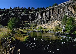
Donner und Blitzen River near Page Springs campground
|
|
|
Location of the mouth of the Donner und Blitzen River in Oregon
|
|
| Country | United States |
| State | Oregon |
| County | Harney |
| Physical characteristics | |
| Main source | southwest of Steens Mountain Harney County, Oregon 6,527 ft (1,989 m) 42°32′02″N 118°43′52″W / 42.53389°N 118.73111°W |
| River mouth | Malheur Lake Harney County, Oregon 4,101 ft (1,250 m) 43°17′30″N 118°49′12″W / 43.29167°N 118.82000°W |
| Length | 60 mi (97 km) |
| Basin features | |
| Basin size | 791 sq mi (2,050 km2) |
| Type: | Wild |
| Designated: | October 28, 1988 |
The Donner und Blitzen River is a river in eastern Oregon. It flows through a dry area called the Harney Basin. This river is about 60 miles (97 km) long. It runs through the southern part of the Harney Basin. This area is about 20 to 80 miles (30 to 130 km) south-southeast of Burns. The river also flows through the Malheur National Wildlife Refuge.
Even though much of the river is marshy, it has beautiful canyons. These canyons were shaped by glaciers long ago. The river is also home to special plants and animals. It is known for its amazing wild trout fishing.
Soldiers of German origin named the river. Donner und Blitzen means "thunder and lightning" in German. You might think of Santa Claus's reindeer when you hear the name. But the river was named after a big thunderstorm. The soldiers experienced this storm when they crossed the river in 1864. In this region, "dry lightning" (lightning without rain) happens almost every day during certain times of the year.
Contents
River's Journey
The Donner und Blitzen River starts on the lower slopes west of Steens Mountain. It begins at about 6,500 feet (1,981 m) high. At its start, it is sometimes a stream that dries up. This spot is about 80 miles (130 km) south-southeast of Burns. It is also about 11 miles (18 km) northwest of Alvord Lake.
Where the River Flows
Many springs nearby feed into the river. These springs create smaller streams that join the Donner und Blitzen. Some of these streams are the South Fork Blitzen River and Little Blitzen River. The river collects these waters and flows north or northwest. It quickly drops down to the flat plateau floor. Then it turns northward and flows into Malheur Lake. Malheur Lake does not have an outlet, meaning water stays there.
The river does not pass through any cities. However, it comes within 2 miles (3.2 km) of Frenchglen. A large part of the river flows through what was once the P Ranch. This was one of the biggest ranches in the western United States. The U.S. Government bought the ranch in 1935.
Home to Special Fish
The Blitzen River is home to a native type of fish. This fish is called the Great Basin Redband Trout. Many other unique plants and animals also live in the Steens Mountain Wilderness area. Over the last 100 years, the number of fish has gone down. This is because more people have been active in the areas around the river.
Protecting the Trout
To help protect the fish, the Donner und Blitzen Red Band Trout Reserve was created. This happened as part of the 2000 Steens Mountain Protection Act. President Clinton and Congress approved this plan. The Reserve was made to "conserve, protect, and enhance" the redband trout. It also helps protect the special plants, fish, and wildlife of the river system.
River Protection and Flow
In 1988, about 72.7 miles (117 km) of rivers in this area were named "Wild and Scenic." This means they are protected by the National Wild and Scenic Rivers System. Another 14.8 miles (23.8 km) were added to this protection in 2000.
The Oregon Department of Environmental Quality (DEQ) watches the river's health. They have noted seven times when the river's temperature was too high.
River Flow Records
The highest water flow ever recorded was on April 26, 1978. It was about 4,270 cubic feet per second (121 m³/s). The lowest flow was on December 9, 1972. It was only 4.2 cubic feet per second (0.12 m³/s). This low flow happened because of widespread freezing.
 | Delilah Pierce |
 | Gordon Parks |
 | Augusta Savage |
 | Charles Ethan Porter |


