
P Ranch facts for kids
Quick facts for kids |
|
|
P Ranch
|
|

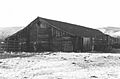
Long Barn at the P Ranch, 1979
|
|

Location in Oregon

Location in the United States
|
|
| Location | Malheur National Wildlife Refuge |
|---|---|
| Nearest city | Frenchglen, Oregon |
| Built | ca. 1880s |
| Architectural style | Simple post and beam |
| NRHP reference No. | 79002060 |
| Added to NRHP | 1979 |
The P Ranch is a historic ranch in southeastern Oregon. It is located on the west bank of the Donner und Blitzen River. This area is now part of the Malheur National Wildlife Refuge.
The ranch was built by Peter French, a famous cattle owner from the 1800s. The P Ranch became the main office for the French-Glenn Livestock Company. This company eventually owned a huge area, over 140,000 acres (56,656 hectares). After Peter French died in 1897, the company slowly sold off the ranch land. In 1935, the U.S. Government bought the rest of the P Ranch. They added it to a nearby wildlife refuge.
Many of the original ranch buildings were taken down in the 1930s. A fire destroyed the main ranch house in 1947. The few buildings that are left at the P Ranch are now listed on the National Register of Historic Places. This means they are important historical sites.
Contents
Early History of the Harney Basin
About 9,800 years ago, the Harney Basin was covered by a very large lake. This lake was about 255,000 acres (103,199 hectares) big. The wetlands around the lake had lots of birds, animals, and plants. These provided plenty of food for the first people living there. Around 3,500 years ago, small villages started to grow near the lakes and rivers. About 1,400 years ago, long dry periods caused the lake and wetlands to shrink.
We don't have records of the very first people in the Harney Basin. But Native American groups used these wetland areas for thousands of years. They lived around Malheur Lake, Harney Lake, and the Donner und Blitzen River. By the time Europeans arrived in the early 1800s, the Northern Paiute people lived in the Harney Basin. This included the area where the P Ranch would later be built.
Fur trappers from the Hudson's Bay Company were the first Europeans to visit the Harney Basin. Peter Skene Ogden traveled along Malheur Lake in 1826. Other fur trapping trips happened in the 1830s. Several military groups passed through the area in the late 1850s. Major Enoch Steen was the first non-native person to explore the Donner und Blitzen River area in 1860. Steens Mountain, a large mountain in southern Harney County, is named after him. In the 1860s, the United States Army set up several military outposts in the Harney Basin.
Peter French and the P Ranch

Peter French was born in Missouri in 1849. As a boy, he moved to California with his family. When he was a young man, French worked for Doctor Hugh J. Glenn. Glenn owned a lot of land in the Sacramento Valley. In 1872, Glenn decided to expand his cattle business into Oregon. He chose 23-year-old Peter French to lead this new project. French traveled north with six vaqueros (cowboys) and 1,200 cattle.
When he reached the Blitzen Valley, French met a prospector named Porter. Porter had not found much gold and wanted to leave. French bought Porter's small group of cattle. He also bought Porter's "P" brand and his rights to the west side of Steens Mountain. French settled along the Donner und Blitzen River. Over the next few years, French drained and fenced thousands of acres of wetlands along the river. This land became the P Ranch, named after the "P" brand he bought from Porter.
By the 1870s, the P Ranch was making good money for Glenn. Cattle were raised in the rich pastures along the river. In the fall, French would drive his cattle 200 miles (322 km) to the railhead (where trains loaded goods) in Winnemucca, Nevada.
In 1883, French married Glenn's daughter, Ella. Three weeks later, Glenn was killed by a former employee. French continued to manage the Oregon cattle business for the Glenn family. He sold more cattle to help pay the family's debts. In 1894, Glenn's family decided to make the French-Glenn partnership into a company. It was called the French-Glenn Livestock Company, and French became its president.
From his base at the P Ranch, French made the company's land even bigger. The ranch stretched 40 miles (64 km) from the foothills of Steens Mountain. It covered both sides of the Donner und Blitzen River all the way to Malheur Lake. It also included the entire south shore of the lake. The ranch also covered all of Happy and Diamond valleys. It even included a large part of the Catlow Valley to the south.
Eventually, the French-Glenn Livestock Company owned over 140,000 acres (56,656 hectares) of the Harney Basin. Some records say the ranch might have been as large as 200,000 acres (80,937 hectares). The company built and kept up 500 miles (805 km) of barbed wire fence. This protected 30,000 to 45,000 cattle, plus 3,000 horses and mules. The ranch had five main areas: Happy Valley, Diamond, Sod-House, Catlow Valley, and the P Ranch. The P Ranch was French's main headquarters in the middle of all the property.

Peter French was not popular with new settlers in the area. This was because he owned or controlled most of the water in the southern Harney Basin. His fences also made it hard for some settlers to get to their own land. On December 26, 1897, French was shot. This happened after a disagreement with a settler who wanted a road across French's land.
After French died, F.C. Lusk became the manager of the P Ranch. He was the company's secretary before French's death. To pay off company debts, Lusk slowly sold off the ranch's property. In 1906, the P Ranch and the nearby Diamond Ranch were sold. They were bought by Henry L. Corbett and his partners. In 1916, Louis F. Swift, who owned the Swift Meat Packing Company, joined the P Ranch partnership. The business then became the Eastern Oregon Live Stock Company.
In the 1920s, a part of the French-Glenn property called the Barton Lake Ranch was bought by John Jenkins. This property includes the famous Pete French Round Barn. In 1935, a large part of the P Ranch became part of the Malheur National Wildlife Refuge.
Malheur National Wildlife Refuge
The Malheur Migratory Bird Refuge was created in 1908. Over the years, the refuge grew to cover 81,786 acres (33,098 hectares) around Malheur Lake. In 1935, the United States Government bought 64,717 acres (26,190 hectares) of P Ranch land. They paid $675,000 to the Eastern Oregon Live Stock Company. This land was added to the refuge. The refuge was later renamed the Malheur National Wildlife Refuge.
During the 1930s, the refuge had three Civilian Conservation Corps (CCC) camps. The CCC was a program that put young men to work during the Great Depression. One camp was at the Sod-House Ranch. A second camp was at Buena Vista Station. The third was about 5 miles (8 km) north of Frenchglen, in the P Ranch area.
CCC crews built many stone buildings for the refuge headquarters. They also built other refuge buildings, lookout towers, and a main patrol road. They constructed four concrete dams, many canals and bridges, and hundreds of miles of fence. The CCC also took down most of the original ranch buildings. The camps closed in 1942.
After the CCC left, the remaining ranch buildings were used by the United States Fish and Wildlife Service. They helped with refuge operations. Sadly, a fire destroyed the main ranch house in 1947. Only the foundation and a stone chimney were left.
The P Ranch played an important part in the history of the cattle industry in the western United States. Because of this, it was listed on the National Register of Historic Places on January 29, 1979. The historic area covers 60 acres (24 hectares) along both sides of the Donner und Blitzen River. Today, the Long Barn is the only historic building still standing at the site.
Structures at P Ranch
At its busiest, the P Ranch had at least twenty-one buildings. Today, only one building and two other historic structures remain. These are the Long Barn, a beef wheel, and some original fences.
The Long Barn was built in the 1880s. It is 150 feet (46 m) long and 50 feet (15 m) wide. It is built with a post and beam style. There are 56 heavy log posts in two rows that hold up the roof. The roof is 30 feet (9 m) high at its peak. The outside of the barn is made of pine and aspen wood. The roof is covered with pine shingles. The Civilian Conservation Corps replaced the original foundation in 1939.
The inside of the barn is one large room. It has a 12-foot (3.7 m) wide center aisle between the two rows of posts. Hay is still stored in this aisle, often stacked up to the roof. Along both sides of the barn are feed racks and animal stalls. The United States Fish and Wildlife Service fixed and restored the Long Barn in 2008. Today, they use it to house horses and store hay.
The ranch property also has an original beef wheel. This was used to lift slaughtered cattle off the ground to cool. It was built in the 1880s, when Peter French had over a hundred ranch workers. To feed everyone, the ranch needed to slaughter two cattle each week. So, the beef wheel was a very important piece of equipment. The wheel is quite large. It had to lift the beef high enough so that it was safe from dogs and coyotes. The wheel is a square pine frame on two large juniper posts.
Several parts of the original stockade fence are still at the P Ranch. These fences are made of juniper slabs buried in trenches. The cross-pieces of the fence were originally tied to the slabs with rawhide. There are also several original willow corrals still existing. These were made by weaving willow branches between upright juniper posts.
Location of P Ranch
The P Ranch Historic District covers 60 acres (24 hectares) along the Donner und Blitzen River. This is in southeastern Oregon. The ranch is about 4,196 feet (1,279 m) above sea level.
The P Ranch is inside the Malheur National Wildlife Refuge. The ranch is 1.5 miles (2.4 km) east of Frenchglen, Oregon. To get there from Frenchglen, travel east 1.5 miles (2.4 km) on the Steens Mountain Loop Road. Then, turn north onto the Malheur National Wildlife Refuge Central Patrol Road. The ranch entrance is on the west side of the road, about 0.25 miles (0.4 km) from the Steens Mountain Loop Road turn.
Images for kids
-
Southeast exterior of Long Barn
-
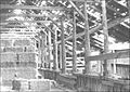
Barn post and beam structure
-
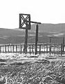
Original P Ranch beef wheel


