Malheur National Wildlife Refuge facts for kids
Quick facts for kids Malheur National Wildlife Refuge |
|
|---|---|
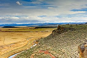
A view of Steens Mountain from an overlook located in the Malheur National Wildlife Refuge
|
|
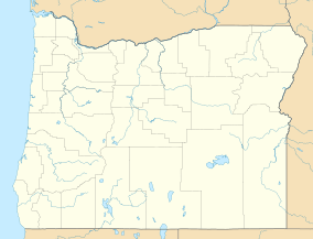
| Location | 30 miles (48 km) south of Burns, Harney County, Oregon, United States |
| Area | 293.37 sq mi (759.8 km2) |
| Elevation | 4,121 ft (1,256 m) |
| Established | 1908 |
| Website | Malheur NWR |
The Malheur National Wildlife Refuge is a special place for wildlife in Oregon. It's located about 30 miles (48 km) south of the city of Burns. This refuge is managed by the United States Fish and Wildlife Service. It covers a huge area of about 187,757 acres (760 km²).
President Theodore Roosevelt created the refuge in 1908. His goal was to protect the homes of many different waterfowl and migratory birds. Today, it's a popular spot for birdwatching, fishing, hunting, and hiking. In 2016, the refuge headquarters gained attention when a group of armed people took it over.
Contents
History of the Refuge
Early Inhabitants: Native Americans
For thousands of years, the Harney Basin region was home to Native American people. Evidence shows they lived here for about 15,000 to 16,000 years. Around Malheur Lake and Harney Lake, the Paiute tribes lived and used the land. They hunted and fished as part of their seasonal travels. The area where the refuge headquarters now stands was once a Paiute settlement.
When settlers arrived, the Paiute people's use of the land became restricted. They were eventually moved to the Malheur Indian Reservation. However, parts of their reservation were taken away and given to settlers. The Paiute people were also denied their promised fishing and hunting rights.
In 1878, the Paiute people were forced to leave their reservation. They were moved to the Yakama Indian Reservation in Washington state, about 350 miles (563 km) away. Many suffered during this difficult journey. After five years, they were allowed to leave. Some moved to other reservations, while others returned to the Harney Basin. In 1972, they created the Burns Paiute Indian Reservation.
Protecting Birds from Plume Hunters
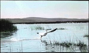
In the late 1800s, the many birds in the Malheur region faced a big threat. Plume hunting was common, where hunters killed birds for their feathers. These showy feathers were used to decorate hats. This hunting greatly harmed the bird populations.
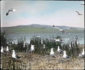
In 1908, wildlife photographers William L. Finley and Herman Bohlman visited the area. They took pictures of the diverse birds and the damage caused by plume hunting. Finley used these photos to convince President Theodore Roosevelt to protect the region.
How the Refuge Was Created
On August 18, 1908, President Roosevelt officially created the Malheur National Wildlife Refuge. It started as the "Malheur Lake Refuge," covering about 81,786 acres (331 km²) around Malheur, Harney, and Mud lakes. Over the years, the refuge grew to its current size of 187,756 acres (760 km²). This expansion happened through government purchases and land exchanges.
During the Great Depression, workers from the Civilian Conservation Corps helped build roads and other structures in the refuge. For many years, cattle were allowed to graze on some parts of the land. However, starting in the 1970s, the number of cattle was reduced. This was done to make sure the wildlife's needs were put first.
Working Together for the Refuge
In 2008, a new plan for managing the refuge began. Many different groups, including ranch owners, worked together on this plan. The final plan, finished in 2013, aimed to balance the needs of wildlife and ranching. It was a compromise that everyone agreed on.
Grazing is still allowed in some areas. It can even help control unwanted plants that harm the refuge's habitat. But if grazing is shown to hurt the wildlife, it can be reduced in those specific areas.
2016 Occupation of the Headquarters
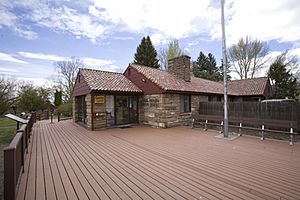
From January 2 to February 11, 2016, a group of armed people took over the refuge's headquarters. They demanded that the federal government give up control of the land. They believed "the people" should have its resources.
Groups interested in protecting the refuge, like the Portland Audubon Society and the Burns Paiute Tribe, were worried. They feared the occupation would stop important work, like preparing for bird migration. They were also concerned about the safety of archaeological sites and Paiute artifacts stored at the headquarters.
Geography and Landscape
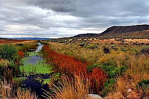
The Donner und Blitzen River flows through the middle of the refuge. Its waters are used to create a large artificial wetland. This area was once a natural wetland. The Donner und Blitzen River flows into Malheur Lake, which then flows into Harney Lake. This forms a large salt lake.
These open waters attract thousands of migrating birds every year. This has been happening for thousands of years. The refuge covers about 187,757 acres (760 km²), including vast marshlands. Summers here are very hot, and winters are very cold. The best times to visit are late spring and early fall.
Malheur National Wildlife Refuge has one of the largest freshwater marsh systems in the western United States. These marshes sit in the dry lakebed of an ancient lake from the Pleistocene Ice Age.
Volcanic Features
On the southeast side of the refuge is the Diamond Craters volcanic field. This area is about 40 miles (64 km) southeast of Burns. It's a field of basalt lava flows, cinder cones, and maars. These features formed from volcanic eruptions that happened about 7,320 to 7,790 years ago.
North of Diamond Craters is an older lava flow called the Voltage Flow. This flow formed about 1.9 million years ago. It created the basin where Malheur, Mud, and Harney lakes now sit. It did this by blocking the path of the ancient Malheur River.
Wildlife and Ecosystems
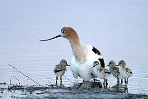
The refuge is home to an amazing variety of wildlife. You can find about 320 species of birds and 58 species of mammals. They live in different habitats like desert, grassland, marsh, and rimrock areas. Malheur is one of the best places for waterfowl to breed in the U.S. It's also a vital stop for hundreds of thousands of birds on the Pacific Flyway migration route.
Many migrating birds rely on this refuge for rest and food. These include northern pintail ducks, tundra swans, sandhill cranes, snow geese, and Ross’ geese. Ducks, grebes, pelicans, and trumpeter swans are attracted to the many ponds, marshes, and lakes. In the higher, drier areas, you might see deer, antelopes, pheasants, and quails.
Importance of the Lakes for Birds
The lakes in Malheur National Wildlife Refuge are crucial feeding areas for migrating waterfowl, waterbirds, and shorebirds. They are also important nesting places for many colonial nesting waterbirds and diving ducks. When a plant called sago pondweed is plentiful, it feeds many canvasbacks, tundra swans, and other ducks.
When conditions are right, thousands of colonial nesting birds use the lake for nesting. These include white-faced ibis, American white pelican, great and snowy egrets, herons, and various gulls and terns. Sometimes, over 10,000 nests have been counted! When water levels drop, exposing mudflats, migrating shorebirds use the lakes extensively. The large open water of Malheur Lake also provides safety for molting geese and ducks from predators.
Redband Trout and Invasive Carp
Redband trout are a type of rainbow trout found in the Harney Basin. This basin has the most diverse and largest amount of redband trout habitat in Oregon. The refuge helps protect these special trout populations. They are survivors from a large ancient lake that once filled the Harney Basin.
Refuge managers have been working to control common carp in the waterways since the 1970s. These invasive fish were likely brought to the refuge before the 1920s as a food source. Carp are aggressive eaters. They reduce food and harm the habitat for the birds that use the refuge's marshes and lakes. In 2014, a special fishing crew was hired to remove these unwanted fish.
Ancient Discoveries: Fossils
Fossilized bones have been found inside and near the Malheur National Wildlife Refuge. Scientists who study fossils have discovered bones of an unidentified camel-like animal. These bones were found in Pleistocene volcanic ash deposits. This site could hold more ancient animal and plant fossils. These fossils are important because similar ones from this time period haven't been found elsewhere in eastern Oregon.
Older Neogene rock layers have also yielded vertebrate fossils. These were found south of Harney Lake. These fossil bones show that the rocks they are in date back to the Middle and Lower Miocene epochs. Also, 22,000-year-old fossil salmon bones have been found. They were discovered near the connection between Malheur and Mud lakes. These salmon fossils suggest that the ancient lake was once high enough to connect directly to the Malheur River.
 | Anna J. Cooper |
 | Mary McLeod Bethune |
 | Lillie Mae Bradford |


