
Malheur Indian Reservation facts for kids


The Malheur Indian Reservation was a special area of land set aside by the United States government for the Northern Paiute tribe. It was located in eastern Oregon and northern Nevada. This reservation existed from 1872 to 1879. The government decided to close the reservation after a conflict called the Bannock War in 1878. This happened because European-American settlers wanted the land. After the reservation closed, more than 500 Paiute people were moved to the Yakama Indian Reservation.
Contents
Creating the Malheur Reservation
On September 12, 1872, President Ulysses S. Grant signed an order to create the Malheur Indian Reservation. It was meant for "all the roving and straggling bands in Eastern and Southeastern Oregon, which can be induced to settle there." The main goal was to stop fights between the Paiute people and the settlers. The Paiute were finding it hard to find enough food, and settlers' farms were spreading onto their traditional lands.
About 800 Northern Paiute people lived in different settlements at that time. These included places like Fort Harney, Fort Klamath, Fort Bidwell, and Fort McDermitt. Three groups of Paiute, led by chiefs Weahwewa, Watta-belly, and Egan, moved to the new reservation. In 1875, Old Winnemucca, a Paiute chief, along with his daughter Sarah Winnemucca and son Natchez, also came to the Malheur Reservation. Their family had faced a terrible event in 1865 when many of their people were lost in a raid.
The reservation covered a large area, about 2,285 square miles (5,920 km2). This included the areas around the South, Middle, and North forks of the Malheur River. At that time, salmon still swam up the Columbia River and the Snake River into the North Fork, all the way from the Pacific Ocean.
Changes to the Reservation Land
Soon after the reservation was created, European American settlers started asking for parts of the land to be removed from the reservation. They wanted more land for themselves. In 1876, settlers asked for the Silvies River Valley and the Harney Lake Basin to be taken out of the reservation.
In January of that year, President Grant agreed to open the northern shores of Malheur Lake for settlement. This was a big problem for the Paiute. This area was where they collected wada seeds, which were an important food source. The Paiute living around Malheur Lake were even known as the Wadatika, meaning "wada-seed-eaters." Settlers along Willow Creek Valley also wanted changes to the reservation's borders.
The reservation was located across important trails. These trails connected northern Grant County (where Chief Joseph of the Nez Perce tribe was told to move) and southern Grant County. After the transcontinental railroad was mostly finished in 1868, cattle ranchers began moving their herds along these trails. They drove cattle to train stations like Winnemucca, Nevada, to send them east. In the high desert of Eastern Oregon, these streams and pastures were very important for feeding the cattle. However, the cattle used water and grazed on lands that were set aside for the Paiute people.
The Bannock War (1878)
In May 1878, the Bannock War began in Idaho. Because of this war, the Paiute people left the Malheur Indian Reservation. They went to Steens Mountain to the south of the Harney Basin for safety. This mountain was a good place to defend because its eastern side rises steeply from the Alvord Desert.
Later that summer, Bannock warriors from Idaho joined them. When the U. S. Army, led by General Oliver Otis Howard, started moving towards them, the Paiute and Bannock decided to move into the Blue Mountains to the north. As they moved, they raided isolated ranches, taking horses and cattle. There were fights with the Army, and people on both sides were harmed.
Near the Umatilla Agency on the Columbia River, the Umatilla tribe saw that the Paiute and Bannock would not win against the larger U.S. Army. So, the Umatilla decided to help the Army. Some Umatilla warriors went into a Paiute and Bannock camp as if to talk. There, they killed Egan, one of the main Paiute war leaders, and some of his followers. After losing their leader, the Paiute groups scattered into the mountains. Many Bannock tried to go back to Idaho. In the end, most Paiute surrendered. They were first held as prisoners at the Malheur Indian Reservation, along with Bannock prisoners.
Closing the Reservation
In November 1878, General Howard was ordered to move about 543 Paiute and Bannock prisoners. They were moved from the Malheur Indian Reservation to the Yakama Indian Reservation in Washington Territory, about 350 miles (560 km) north. Other Paiute and Bannock people were spread out across Eastern Oregon, northeastern California, and northern Nevada. They worked for settlers or found food by hunting and gathering. More than a year after the war, most had not returned to the reservation, even though the U.S. government had asked them to. Some others were held at Vancouver Barracks in Washington.
Ranchers and settlers had already started letting their cattle graze on the best grasslands of the Malheur Indian Reservation. The U.S. Army was slow to remove these people who were using the land illegally. In his report in August 1879, Agent W. V. Rinehart said the reservation should be closed. He believed that there wasn't enough support for all the Native American agencies in Oregon to work well. In October of that year, the Commissioner of Indian Affairs officially closed the agency.
The Burns Paiute Indian Reservation Today
Today, a small group of Paiute people live on a small piece of land called the Burns Paiute Indian Reservation. This area is about 760 acres (3.1 km2) along the Silvies River, just north of Burns, Oregon. Other Paiute groups are recognized by the government as separate tribes on different reservations.
Images for kids
-
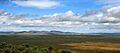
The Harney Basin, looking north towards Burns, Oregon, and the Blue Mountains.
-
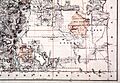
A map of the Malheur Reservation, drawn by the U.S. General Land Office.
