High Desert (Oregon) facts for kids
Quick facts for kids High Desert (Oregon) |
|
|---|---|
| "Oregon Outback" and "Great Sandy Desert" | |
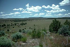
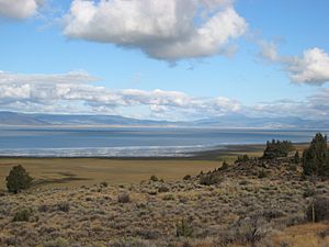
The Oregon high desert near Frenchglen
|
|
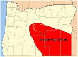
Map of Oregon's high desert region
|
|
| Length | 130 mi (210 km) |
| Width | 200 mi (320 km) |
| Geography | |
| Location | Oregon, United States |
| Population centers | Bend, Burns, Lakeview, and Prineville |
| Borders on | Cascade Range (west) Blue Mountains (north) Idaho border (east) Nevada border (south) |
The Oregon high desert is a special part of Oregon, a state in the United States. It is located east of the Cascade Range mountains and south of the Blue Mountains. This area covers much of central and eastern Oregon. It is called "high desert" because it is quite high up, averaging about 4,000 feet (1,200 m) above sea level.
Even though it's called a desert, it's not as dry as places like the Sahara. It gets about 15 inches (380 mm) of rain each year. This is dry compared to western Oregon, but most of the area is actually scrubland or steppe. This means it has tough grasses and bushes, not just sand. The highest point in this region is Steens Mountain, which stands tall at 9,733 feet (2,967 m).
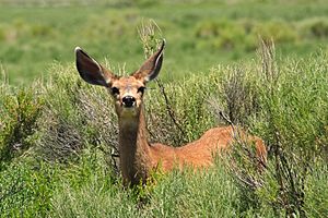
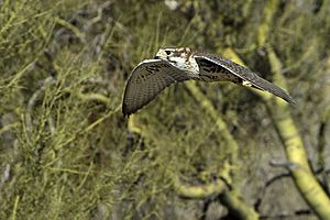
The land here was formed by ancient lava flows and changes in the Earth's crust. Over millions of years, volcanoes erupted, and then the land stretched and cracked. This created the unique landscape of mountains and valleys we see today. Many animals live here, like pronghorn and mule deer. Common birds include sage-grouse and prairie falcon. The most common tree is the western juniper.
Contents
Geography of Oregon's High Desert
The high desert area of Oregon is in the central and southeastern parts of the state. It stretches for about 200 miles (320 km) from central Oregon to the Idaho border. It also goes about 130 miles (210 km) south to the Nevada border. This large area covers roughly 24,000 square miles (62,000 km2). Most of it is found in five counties: Crook, Deschutes, Harney, Lake, and Malheur.
Mountains and Valleys
The high desert gets its name because it is generally high up. The average elevation is about 4,000 feet (1,200 m). To the west, it is bordered by the Cascade Range. The Blue Mountains form the northern edge of this semi-dry plateau. The southern part of the high desert is part of a larger area called the Basin and Range Province. This area has many large alkali lakes and tall cliffs. Some of these cliffs rise more than 2,000 feet (610 m) high. Steens Mountain is the highest point in the region, reaching 9,733 feet (2,967 m) above sea level.
Rivers and Lakes
Many rivers flow through the high desert. These include the Deschutes River and its branch, the Crooked River. Other important rivers are the Malheur, Owyhee, and John Day rivers. All these rivers eventually flow into the Columbia River.
Some smaller rivers in the high desert flow into "closed basins." This means their water does not reach the ocean. Instead, it flows into lakes that have no outlet. The Chewaucan River, the Donner und Blitzen River, and the Silvies River are examples. They all flow into some of the high desert's salt lakes.
How Land is Used
The U.S. government owns most of the land in eastern Oregon. The Bureau of Land Management (BLM) manages a huge amount of this land. It's over 13.6 million acres (55,000 km2) in several districts. Most of this land is in Oregon's high desert. Also, parts of the Crooked, Deschutes, Donner und Blitzen, Malheur, and Owyhee rivers are protected as "Wild and Scenic Rivers."
Farming is the biggest business in this area. Ranchers use large areas of private and government land for grazing their animals. They raise cattle and sheep. Because there isn't much rain, most crops need irrigation (extra water). Farmers grow alfalfa and other hay crops. They also grow wheat, oats, barley, potatoes, onions, sugar beets, and mint.
Geology: How the Land Was Formed
The high desert's landscape was shaped by powerful forces over millions of years.
Ancient Lava Flows
About 17 to 15 million years ago, hot liquid rock called magma rose from deep inside the Earth. It burst out of cracks in the ground near the borders of Oregon, Idaho, and Washington. These were huge lava floods. The lava flowed for hundreds of miles, sometimes covering 10,000 square miles (26,000 km2) to a depth of 100 feet (30 m). These lava flows covered half of Oregon, creating a strong base layer of rock called the Columbia River Basalt Group. This is the foundation of much of the high desert.
Stretching Earth and New Volcanoes
After the first big eruptions, the Earth's outer layer began to stretch and crack. From 15 to 2 million years ago, this stretching created hundreds of new volcanoes. These volcanoes added more layers of lava on top of the older ones. They also left behind many lava tubes, which are like underground tunnels. Many of these old volcanoes and smaller cinder cones can still be seen today. As the land continued to pull apart, large fault-block mountains formed. These mountains and the valleys between them created the "basin and range" landscape that is common in Oregon's high desert.
Ice Ages and Giant Lakes
Over the last 2 million years, several ice ages changed the land even more. When the huge ice sheets melted, the water filled many of the low areas. This created very large ancient lakes, called pluvial lakes. Places like the Goose Lake, Harney, and Klamath areas were once covered by these giant lakes. Some of these lakes were as big as 1,000 square miles (2,600 km2). However, as the climate became drier, these lakes shrank. Today, lakes like Goose Lake, Harney Lake, Malheur Lake, Summer Lake, Lake Abert, and the Warner Lakes are what's left of those ancient, much larger bodies of water.
Climate of the High Desert
The Oregon high desert does not get much rain. Most areas receive less than 15 inches (380 mm) of precipitation each year. For example, Bend, the biggest city in the region, gets only about 12 inches (300 mm) of rain annually. Burns gets around 11 inches (280 mm). Some very dry spots, like Rome and Whitehorse Ranch, receive only about 8 inches (200 mm) in an average year.
However, some mountainous areas get a lot more snow. Lakeview, a city high up in the mountains, gets almost 68 inches (1,700 mm) of snow each year on average.
Most of the rain and snow falls in the winter months. The amount of precipitation then slowly decreases through the summer and fall. Some eastern and southern parts of the region get the most rain in late spring and early summer. For example, at Hart Mountain, the wettest time is from March to June. The driest months across the high desert are July, August, and September. Even then, there can still be some thunderstorms.
| City | Jan | Feb | Mar | Apr | May | Jun | Jul | Aug | Sep | Oct | Nov | Dec | Annual Max/Min |
Citation |
|---|---|---|---|---|---|---|---|---|---|---|---|---|---|---|
| Bend | 40/23 | 44/25 | 51/27 | 57/30 | 65/36 | 73/41 | 81/46 | 81/46 | 72/39 | 62/32 | 46/28 | 40/23 | 102 / -24 | |
| Burns | 35/14 | 40/19 | 49/25 | 57/29 | 66/36 | 75/41 | 85/46 | 84/44 | 75/35 | 62/26 | 45/21 | 35/15 | 102 / -28 | |
| Lakeview | 39/21 | 42/24 | 48/28 | 56/32 | 65/38 | 74/44 | 84/55 | 83/48 | 75/42 | 63/33 | 46/26 | 39/21 | 102 / -20 | |
| Prineville | 42/21 | 48/24 | 54/25 | 61/28 | 69/34 | 77/40 | 86/43 | 86/42 | 78/35 | 66/29 | 49/25 | 42/21 | 107 / -34 |
History of the High Desert
Native Peoples and Early Settlers
The first people to live in the high desert were the Northern Paiute people. These Native Americans were hunter-gatherers. They moved around to find food like nuts, roots, seeds, berries, eggs, and animals such as deer and rabbits. They were skilled at making sandals, traps, fishing nets, and weaving baskets. Some baskets were so tightly woven they could even hold water! We know people were weaving baskets here at least 9,000 years ago.
In the 18th and early 19th centuries, the Northern Paiute often had conflicts with other tribes. Later, in the 1860s, a conflict called the Snake War happened between the natives and white settlers. This war sadly caused many Northern Paiute people to lose their lives. After the war, the white settlers created the Malheur Indian Reservation for the Northern Paiute and other tribes.
White settlers started moving into the high desert in the 1850s and 1860s. Many came from western Oregon, crossing the Cascade Mountains. They wanted to claim land in eastern Oregon. As more land was settled, agreements were made with native tribes. Often, these agreements forced the tribes to leave their traditional lands and move to reservations.
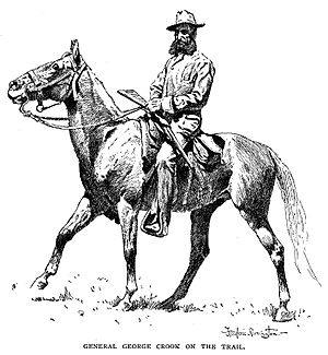
In 1866, American soldiers set up a military camp called Camp Warner. It was near what is now Hart Mountain National Antelope Refuge. The soldiers first built it east of the Warner Lakes. But Maj. Gen. George Crook didn't like that spot. He built a road across the lakes and moved the camp to the western side.
Founding of Cities
Of the four main cities in the high desert, Prineville was the first to be established. Its post office opened in 1871. It was named after Barney Prine, a local merchant. Lakeview's post office opened in 1876. At that time, Goose Lake was larger and could be seen from the post office.
The Burns post office opened in 1884, and the city was founded in 1891. It was named after the Scottish poet Robert Burns. Bend got its name from "Farewell Bend." This was a spot where pioneers last saw the Deschutes River as they traveled. The Bend post office opened in 1904.
In 1878, the Bannock people and northern Shoshone tribes fought against white settlers in the Bannock War. This war was about the destruction of camas root, a key food source for the natives, by settlers' hogs. After the war, the native tribes were moved to different reservations. The Northern Paiute were sent to the Yakama Indian Reservation and later spread out to other reservations.
In 1897, white settlers created the 13,736-acre (5,559 ha) Burns Paiute Reservation. It is just north of Burns. This reservation was officially recognized in 1972. It is home to the descendants of the Wada Tika band of Northern Paiutes.
Names for the Region
In the 1800s, Oregon's high desert had many different names. It was called the Great Sandy Desert, even though it has very little sand. Other names included the Rolling Sage Plain and the Artemisia Desert. Over the years, people have also called it Oregon's Empty Quarter, the Great Wide Open, and Oregon's Cowboy Country. Today, many locals call it the Oregon Outback. However, "High Desert" is the official name for a plain in Deschutes County.
Flora and Fauna: Plants and Animals
The Oregon high desert is home to many different plants and animals. They are all adapted to live in this dry environment.
Plants of the High Desert
The Oregon Badlands Wilderness, located about 15 miles (24 km) east of Bend, shows typical high desert plants. These native plants can survive on less than 12 inches (300 mm) of rain each year. The area is mostly covered by big sagebrush and rabbitbrush. You can also find tough grasses like Idaho fescue and bluebunch wheatgrass.
In the spring, beautiful native wildflowers bloom. These include yellow Oregon sunshine, dwarf purple monkeyflower, sulfur buckwheat, Indian paintbrush, and mariposa lilies. Other common high desert wildflowers are buttercups, larkspur, phlox, primroses, and coral mallow. The Oregon Badlands Wilderness also has the oldest known tree in Oregon. It is a western juniper that is thought to be more than 1,600 years old!
Animals of the High Desert
Hundreds of animal species live in Oregon's high desert. For example, the Hart Mountain National Antelope Refuge alone has over 300 species. This includes 239 types of birds and 42 types of mammals.
Across the entire high desert region, you can commonly find mule deer, pronghorn, coyotes, American badgers, and black-tailed jackrabbits. In some areas, you might also see elk, bighorn sheep, cougars, bobcats, gray foxes, red foxes, North American porcupines, and North American beavers.
Smaller mammals that live here include long-tailed weasels, woodchucks, cottontail rabbits, pygmy rabbits, and different kinds of squirrels and mice. Many types of bats also live in Oregon's high desert.
Common birds in the high desert are sage-grouse, quail, and sage thrasher. Near lakes and rivers, you might spot American dusky flycatchers, yellow warblers, house wrens, and western meadowlarks. In other parts of the region, you can find mountain chickadees, common ravens, and white-headed woodpeckers. Birds of prey, like owls, hawks, prairie falcons, golden eagles, and bald eagles, also hunt in the high desert.
 | Stephanie Wilson |
 | Charles Bolden |
 | Ronald McNair |
 | Frederick D. Gregory |


