
Chewaucan River facts for kids
Quick facts for kids Chewaucan River |
|
|---|---|

Footbridge over the Chewaucan River
|
|

Location of the mouth of the Chewaucan River in Oregon
|
|
| Country | United States |
| State | Oregon |
| County | Lake |
| Physical characteristics | |
| Main source | Fremont National Forest 5,151 ft (1,570 m) 42°27′49″N 120°36′38″W / 42.46361°N 120.61056°W |
| River mouth | Lake Abert 4,258 ft (1,298 m) 42°31′21″N 120°14′59″W / 42.52250°N 120.24972°W |
| Length | 53 mi (85 km) |
| Basin features | |
| Basin size | 651 sq mi (1,690 km2) |
The Chewaucan River is a river in southern Oregon, USA. It's part of the Great Basin area, which means its water doesn't flow to the ocean. The river is about 53 miles (85 km) long and flows through forests, government land, and private farms. Its watershed (the area of land where all the water drains into the river) is about 651 square miles (1,690 km2). This area has forests, marshy wetlands, and grassy fields. The Chewaucan River is home to many animals, especially a special kind of fish called the Great Basin redband trout.
Contents
Where the Chewaucan River Flows
The Chewaucan River flows for 53 miles (85 km) through Lake County, Oregon. It starts when two smaller streams, Elder Creek and Dairy Creek, join together. These streams begin high up in the Gearhart Mountain area.
After joining, the Chewaucan River flows north through the Fremont-Winema National Forests. Many other small creeks, like Ben Young Creek and Bear Creek, add their water to the river here. The river then leaves the forest near the town of Paisley.
The Chewaucan River flows through Paisley and into an area that used to be a large marsh. Now, this marsh has been turned into farmland. The river's flow here is controlled by special structures called weirs and irrigation canals. These help direct water to irrigate the fields.
The river then narrows down at a spot called The Narrows. After this, it opens up into another marshy area. Finally, Crooked Creek joins the Chewaucan River just before it flows into Lake Abert. Lake Abert is a special lake because no water flows out of it.
The Chewaucan River Watershed

The Chewaucan watershed is the entire area of land that drains water into the Chewaucan River. It covers about 651 square miles (1,690 km2). This area includes forests, marshy wetlands, and rural ranch land.
The upper part of the watershed, closer to where the river starts, is mostly forest. You can find trees like ponderosa pine, lodgepole pine, and white fir here. There are also groves of aspen trees near springs and meadows.
Below Paisley, the river flows through the Chewaucan Marsh, which is about 42,000-acre (17,000 ha) big. In the past, this marsh was covered with native grasses and plants like tufted hairgrass and sedges. However, people built weirs and canals to use the river's water for irrigation. This changed the marsh into pasture lands for farming. The land around the marsh is a dry, semi-desert area with alkaline soil, so only plants that can handle salty soil grow there.
River Life and Habitat
In the past, a special fish called the Great Basin redband trout lived all along the Chewaucan River. They would swim from the river's beginning near Gearhart Mountain down to the Chewaucan Marsh. The marsh had lots of insects for them to eat. These native trout could grow very large, sometimes up to 30 inches (76 cm) long, before swimming back upstream to lay their eggs.
In the late 1800s, ranchers built dams, weirs, and canals to irrigate their fields. This changed the river and the marsh. Over time, the number of native redband trout went down. In 1925, the Oregon Game Commission started putting hatchery-raised trout into the river to try and help.
By 1994, the Great Basin redband trout was considered for protection because its numbers were so low. To help the native fish, the Oregon Department of Fish and Wildlife stopped adding hatchery fish in 1998. This was a difficult decision for the local community in Paisley.
Scientists later found that the native trout had not mixed with the hatchery fish. This was good news! Once the stocking stopped, the native redband population started to grow faster than expected. However, the dams and weirs still made it hard for fish to move freely up and down the river. Fish that swam past the Paisley town weir often couldn't survive in the irrigation canals or return upstream to lay eggs.
In 1996, a small group of native redband trout was found in a private reservoir just before the river flows into Abert Lake. This showed that the redband trout could live in the whole river system if they could get past the man-made barriers.
Many groups, including the United States Forest Service, Oregon Fish and Wildlife, the Paisley community, and local ranchers, worked together. Their goal was to make the Chewaucan River fish-friendly again. They started projects to help fish migrate. In 2002, old pipes under roads (culverts) were replaced with new ones that fish could swim through. In 2003, they began replacing the Paisley town weir. More projects were funded in 2004.
Since the Paisley weir project was finished in 2006, large redband trout can now swim downstream in the spring and return from the marsh area to the upper river to lay eggs. The town of Paisley even has an annual fishing derby to celebrate the return of these native fish!
-
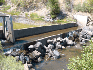
Paisley irrigation weir
-
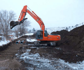
Restoration project
-

Fish-friendly culverts


Besides fish, the Chewaucan Marsh is home to many different birds. You can find nesting ducks and sandhill cranes there. It also has colonies of white-faced ibis, great egrets, and snowy egrets. The area is also an important stop for migrating birds like double-crested cormorants, snow geese, and black-crowned night-herons.
Fun Things to Do: Recreation
There are several campgrounds along the Chewaucan River where you can stay. The most popular one is called Chewaucan Crossing campground.
This campground is located in the Fremont–Winema National Forest. It's about 8.5 miles (13.7 km) southwest of Paisley. The campground has five campsites with picnic tables, fire pits, and restrooms.
Chewaucan Crossing is also a starting point for hiking on the Fremont National Recreation Trail. This trail is about 115-mile (185 km) long. The elevation at Chewaucan Crossing is 4,810 feet (1,470 m) above sea level. Because of cold winters, the campground is usually closed from November to April.
