
Owyhee River facts for kids
Quick facts for kids Owyhee River |
|
|---|---|

The Owyhee River
|
|

Map of the Owyhee River watershed
|
|
| Country | United States |
| State | Nevada, Idaho, Oregon |
| City | Rome, Oregon |
| Physical characteristics | |
| Main source | Near Wild Horse Elko County, Nevada 6,860 ft (2,090 m) 41°30′17″N 115°44′30″W / 41.50472°N 115.74167°W |
| River mouth | Snake River Canyon County, Idaho/Malheur County, Oregon 2,185 ft (666 m) 43°48′46″N 117°01′32″W / 43.81278°N 117.02556°W |
| Length | 280 mi (450 km) |
| Basin features | |
| Basin size | 11,049 sq mi (28,620 km2) |
| Type: | Wild |
| Designated: | March 30, 2009 |
The Owyhee River is a river in the western United States. It flows through northern Nevada, southwestern Idaho, and southeastern Oregon. The river is about 280 miles (450 km) long.
The Owyhee River is a tributary of the Snake River. Its drainage basin (the area of land where water collects and drains into the river) is very large. It covers about 11,049 square miles (28,620 km2). This makes it one of the biggest parts of the larger Columbia River drainage area.
The Owyhee River flows through a dry, high plateau region. It starts in northeastern Nevada and generally flows north. It passes near the borders of Oregon and Idaho before joining the Snake River. The area around the Owyhee River is very quiet, with few people living there. The river and its smaller streams have carved deep canyons into the Owyhee Plateau. Some of these canyons have steep, straight walls and can be over 1,000 feet (300 m) deep.
Contents
History of the Owyhee River
How the River Got Its Name
The land around the Owyhee River was once home to the Shoshone and Bannock Native American tribes. The name "Owyhee" comes from an old spelling of "Hawaii."
The river was named after three Hawaiian trappers. They worked for the North West Company and were sent to explore this unknown river. Sadly, they never returned to their meeting point near the Boise River. They were never seen again. Because of this, the river and the surrounding area were named "Owyhee."
In 1819, these three Hawaiian trappers were probably killed by Native Americans. It wasn't until 1820 that another explorer, Donald MacKenzie, learned about their deaths. An early map from 1825 shows the name "Owhyhee River." Later, in 1826, a fur trapper named Peter Skene Ogden also called it the "Owyhee River."
Gold and Silver Mining

In 1863, gold and silver were found in the Owyhee region. This discovery brought many miners to the area for a short time. They set up mining camps, but most of these camps are now gone. The first gold was found along Jordan Creek. Mining quickly spread throughout the Owyhee area.
Miners used different methods, including digging for gold in riverbeds and creating underground mines. This mining activity lasted for a long time in the region. However, this movement of miners into Native American lands led to the Snake War between 1864 and 1868.
Jean Baptiste Charbonneau's Grave
In 1866, Jean Baptiste Charbonneau died near Jordan Valley. He was the son of Sacagawea, a famous Native American woman who helped the Lewis and Clark expedition. Jean Baptiste caught a cold after crossing the Owyhee River. He was traveling from California to new gold areas in Montana.
His grave is now well marked. You can find it off Highway 95, near Danner.
River's Path
The Owyhee River starts in northeastern Nevada, in Elko County. It flows north, passing through Wild Horse Reservoir. Then it goes northeast. The river flows through the Humboldt-Toiyabe National Forest. It also passes by the towns of Mountain City and Owyhee. These towns are part of the Duck Valley Indian Reservation.
Next, the Owyhee River enters southwestern Idaho. It flows northwest for about 50 miles (80 km) through Owyhee County. The South Fork Owyhee River joins it from the south. The Little Owyhee River is the main stream that flows into the South Fork.
The Owyhee River then enters southeastern Oregon. It flows mostly north, in a zigzag path, west of the Idaho border. Other rivers join it, like the West Little Owyhee River, the Middle Fork Owyhee River, and the North Fork Owyhee River. These three meet at a place called "Three Forks."
The river then flows through the Owyhee Canyon. It turns north, passing east of Burns Junction. Finally, the Owyhee River flows into the Snake River on the border between Oregon and Idaho. This is about 5 miles (8.0 km) south of Nyssa, Oregon.
Owyhee Dam and Lake Owyhee
About 20 miles (32 km) upstream from where it meets the Snake River, the Owyhee River is blocked by the Owyhee Dam. This dam creates a long, winding lake called Lake Owyhee, which is about 52 miles (84 km) long.
The U.S. Bureau of Reclamation built the dam mainly to provide water for farms in southeastern Oregon and southwestern Idaho. Farmers in this area grow crops like onions and hops. The Owyhee Dam was built in 1933. It stopped fish like salmon from swimming up the Owyhee River to lay their eggs.
You can visit Lake Owyhee State Park and the beautiful Leslie Gulch along the eastern shore of the lake.
Protected Areas

In 1984, the United States Congress decided to protect 120 miles (190 km) of the Owyhee River. This part of the river was named an Owyhee Wild and Scenic River. This means the river is kept in its natural, free-flowing state.
This protected section includes the river below the Owyhee Dam. Here, the river flows through deep, remote canyons. These canyons are home to many animals, including mountain lions, bobcats, mule deer, California bighorn sheep, and many types of raptors (birds that hunt).
In 2009, a law called the Omnibus Public Land Management Act of 2009 protected even more land around the Owyhee River in Idaho. It set aside 323,274 acres (130,824 ha) as wilderness areas. These new wilderness areas include:
- North Fork Owyhee Wilderness - 43,413 acres (17,569 ha)
- Owyhee River Wilderness - 267,328 acres (108,184 ha)
- Pole Creek Wilderness - 12,533 acres (5,072 ha)
More recently, in 2019, a new plan called the Owyhee Act was introduced. This plan aims to protect about 1 million acres (400×103 ha) of the Owyhee canyonlands as wilderness. It also suggests improving roads to help visitors explore the area. This plan has support from both ranchers and groups that want to protect nature. It also protects another 14.7 miles (23.7 km) of the river under the Wild and Scenic Rivers Act.
Tributaries of the Owyhee River
Many smaller rivers and streams flow into the Owyhee River. These are called tributaries. Some of the important ones include:
- Jordan Creek is about 99 miles (159 km) long. It flows west from near Silver City, Idaho, to near Rome, Oregon.
- The West Little Owyhee River starts near the Nevada-Oregon border. It is about 57 miles (92 km) long. It flows east and then sharply north through the Owyhee Desert to join the Owyhee River.
- The Lake Fork West Owyhee River is a short stream that flows into the West Little Owyhee River. It starts in southern Malheur County, Oregon.
- The Little Owyhee River is about 61 miles (98 km) long. It flows east from eastern Humboldt County, Nevada, into the Owyhee Desert. It joins the South Fork Owyhee River.
- Blue Creek is about 53 miles (85 km) long. It flows south through Owyhee County, Idaho, and near the town of Riddle, Idaho. It then flows into the Duck Valley Indian Reservation.
Images for kids
-
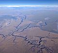
Aerial view of the Owyhee River in Oregon, looking southeast into Idaho, with the Three Forks Recreation Site at left

See also
 In Spanish: Río Owyhee para niños
