Boise River facts for kids
Quick facts for kids Boise River |
|
|---|---|
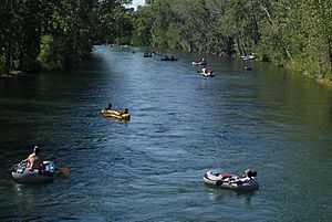
Floating on the river through Boise in 2004
|
|
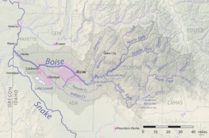
The Boise River watershed
|
|
| Country | United States |
| State | Idaho |
| Physical characteristics | |
| Main source | Sawtooth Range Idaho 3,497 ft (1,066 m) 43°42′48″N 115°38′9″W / 43.71333°N 115.63583°W |
| River mouth | Snake River Idaho 2,100 ft (640 m) 43°49′15″N 117°1′34″W / 43.82083°N 117.02611°W |
| Length | 102 mi (164 km) |
| Basin features | |
| Basin size | 4,100 sq mi (11,000 km2) |
The Boise River is a river about 102 miles (164 km) long in the Northwestern United States. It flows into the Snake River. The river starts in the rugged Sawtooth Mountains in southwestern Idaho, northeast of the city of Boise. It also drains part of the western Snake River Plain.
The area the river drains, called its watershed, is about 4,100 square miles (10,600 km²). This area has many different kinds of places, like high mountain canyons, forests, grasslands, farms, and cities.
Contents
Where Does the Boise River Start?
The Boise River begins with three separate parts, called forks, high up in the Sawtooth Mountains. These forks are the North Fork, Middle Fork, and South Fork.
The North and Middle Forks
The North Fork is about 50 miles (80 km) long. It starts in the Sawtooth Wilderness Area, about 60 miles (97 km) northeast of Boise. It flows southwest through the Boise National Forest.
The Middle Fork is about 52 miles (84 km) long. It starts close to the North Fork in the southern Sawtooth Wilderness Area. It flows west-southwest near the town of Atlanta. The North Fork and Middle Fork then join together to form the main Boise River. This meeting point is about 15 miles (24 km) southeast of Idaho City.
The main river then flows southwest into the Arrowrock Reservoir. Here, it is joined by the South Fork.
The South Fork
The South Fork is about 101 miles (163 km) long. It starts in northern Camas County in the Smoky Mountains and Soldier Mountains. These mountains are part of the Sawtooth National Forest, north of Fairfield. This is about 65 miles (105 km) east of Boise.
The South Fork flows southwest through a rocky canyon. It then fills the Anderson Ranch Reservoir. After that, it turns northwest and joins the main river as part of the Arrowrock Reservoir. This is about 20 miles (32 km) east of Boise.
How the River Flows Through Boise
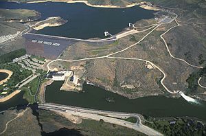
After the South Fork joins the main river, the Boise River flows west. It picks up another important stream called Mores Creek. The river then passes through Lucky Peak Dam and comes out of the hills southeast of Boise.
Before it reaches the city, the river flows over several dams that help divert water for irrigation. The first and largest of these is the Boise River Diversion Dam. This dam helps send water into the New York Canal, which goes to Lake Lowell. Another dam, the Eckert Diversion Dam, sends water into the Ridenbaugh Canal.
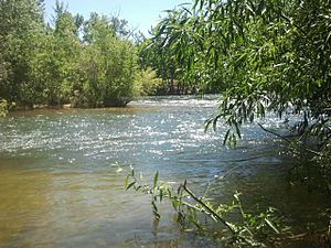
As the river flows through Boise, it is surrounded by a beautiful, wooded area called the Boise greenbelt. This is a popular place for walking and biking. The river then flows west across the flat land of the Treasure Valley. It becomes a braided stream, meaning it splits into many smaller channels, as it crosses northern Canyon County.
Finally, the Boise River flows into the Snake River. This happens west of Parma, near the border between Idaho and Oregon. The river's elevation here is about 2,100 feet (640 meters) above sea level.
History of the Boise River
In the early 1800s, the river was sometimes called "Reed's River." It was named after John Reed, who explored parts of the river in 1813 and 1814.
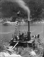
The river's water is used to irrigate (water) farms on the flat land west of Boise. Large dams were built on the river to create reservoirs (big lakes). These dams were part of the "Boise Project" by the United States Bureau of Reclamation. They were built to provide:
- Water for farming
- Electricity (hydroelectricity)
- Drinking water for people
- Control floods
Major Dam Projects and Dates
Here are the years when the main parts of the Boise Project were finished:
- 1909 – Boise River Diversion Dam and the New York Canal
- 1915 – Arrowrock Dam
- 1950 – Anderson Ranch Dam (on the South Fork)
- 1955 – Lucky Peak Dam (built by the United States Army Corps of Engineers)
Fun Activities on the Boise River
The Boise River is a very popular place for recreation, especially for floating. Many people enjoy floating or tubing down the river. They usually start at Barber Park and finish at Ann Morrison Park. This trip is about 6 miles (10 km) long and passes several small dams and bridges.
Above the Lucky Peak Dam at the Lucky Peak Reservoir, Water skiing is a popular sport.
Fishing on the Boise River
The river is also a great spot for fishing.
Fish in the Lower River
In the lower parts of the river, where the water is warmer, there isn't as much fish. This is because the water flows slowly in summer and can have runoff from farms. Here, you might catch largemouth bass, smallmouth bass, and channel catfish.
Fish in the Upper River
Upstream from Star, the river is colder and has more types of fish. The most common fish here is the mountain whitefish. You can also find rainbow trout (some raised in hatcheries and some wild) and young brown trout.
Even further upstream, above Lucky Peak and Arrowrock reservoirs, the river and its smaller streams have excellent numbers of wild rainbow trout, mountain whitefish, and bull trout. This is especially true just below the Anderson Ranch Reservoir, where the South Fork becomes a great fishing spot for about 5 miles (8 km).
Fishing Methods
Fishermen often use different methods to catch fish.
- Spin-fishermen use lures like roostertail spinners and bait such as worms and Powerbait.
- Fly fishermen use various flies that look like the insects found in the river area, as well as streamers.
See also
 In Spanish: Río Boise para niños
 | William M. Jackson |
 | Juan E. Gilbert |
 | Neil deGrasse Tyson |


